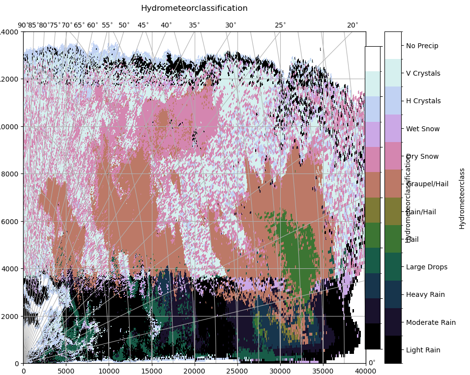
Hydrometeorclassification#
[1]:
import wradlib as wrl
import xarray as xr
import os
import numpy as np
import matplotlib as mpl
import matplotlib.pyplot as plt
import warnings

warnings.filterwarnings("ignore")
try:
    get_ipython().run_line_magic("matplotlib inline")
except:
    plt.ion()
from scipy import interpolate
import datetime as dt
import glob
The hydrometeorclassification code is based on the paper by Zrnic et.al 2001 utilizing 2D trapezoidal membership functions based on the paper by Straka et. al 2000 adapted by Evaristo et. al 2013 for X-Band.
Precipitation Types#
[2]:
pr_types = wrl.classify.pr_types
for k, v in pr_types.items():
    print(str(k) + " - ".join(v))
0LR - Light Rain
1MR - Moderate Rain
2HR - Heavy Rain
3LD - Large Drops
4HL - Hail
5RH - Rain/Hail
6GH - Graupel/Hail
7DS - Dry Snow
8WS - Wet Snow
9HC - H Crystals
10VC - V Crystals
11NP - No Precip
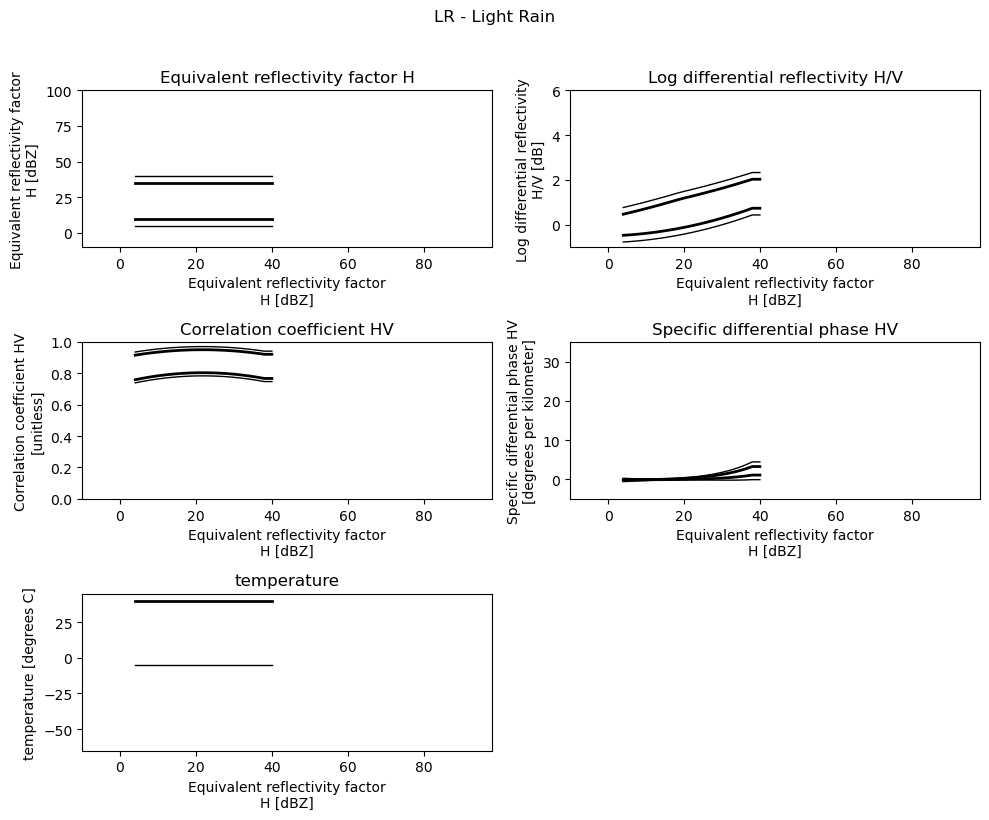
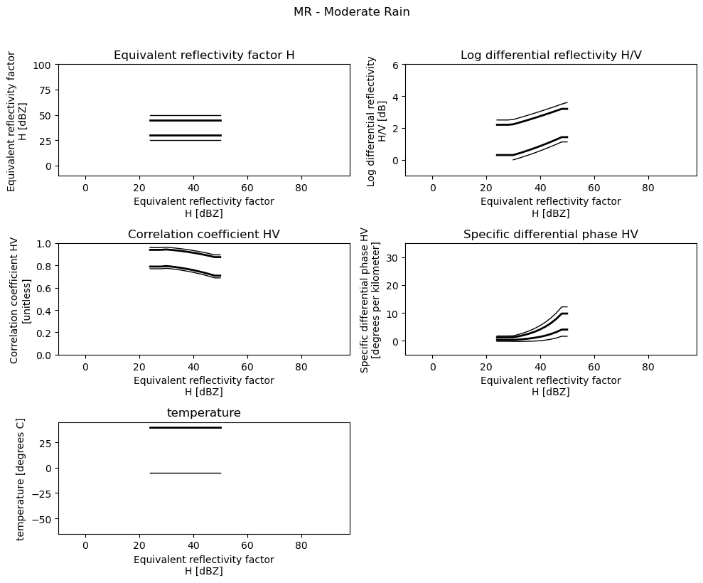
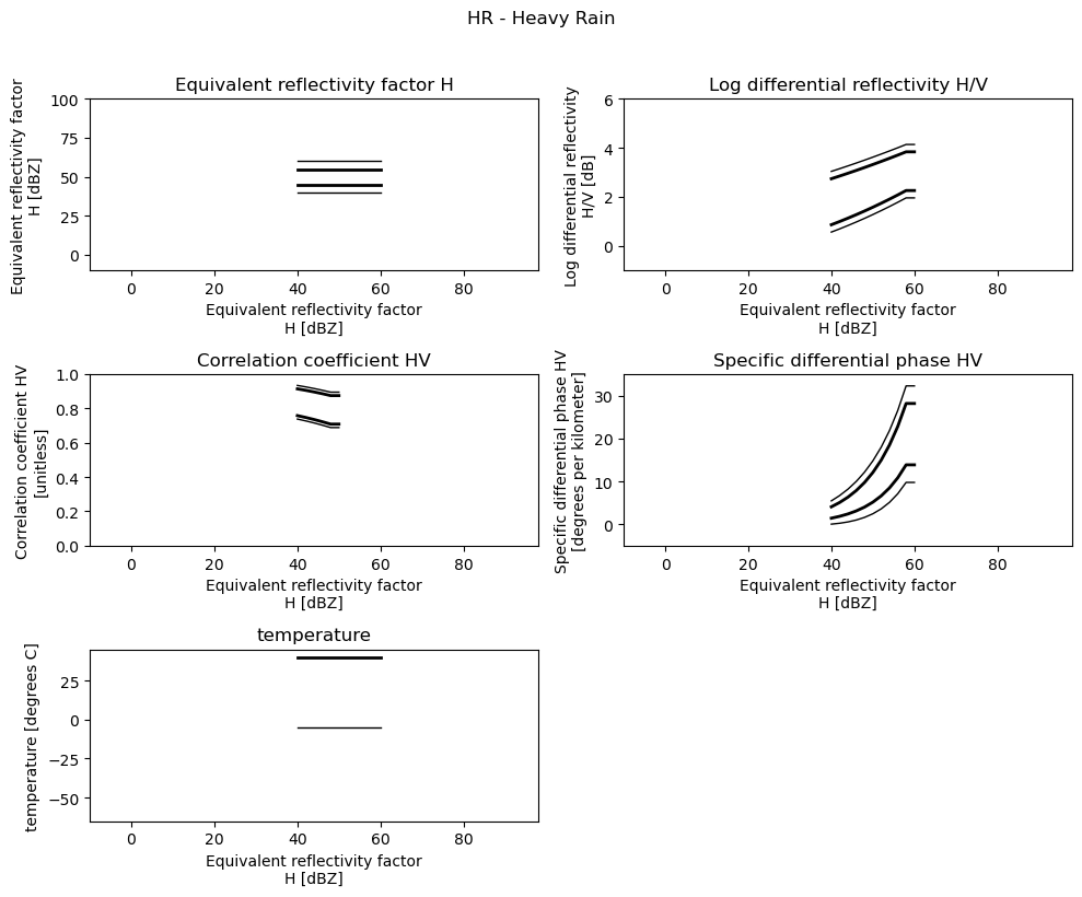
Membership Functions#
Load 2D Membership Functions#
[3]:
filename = wrl.util.get_wradlib_data_file("misc/msf_xband_v1.nc")
msf = xr.open_dataset(filename)
display(msf)
Downloading file 'misc/msf_xband_v1.nc' from 'https://github.com/wradlib/wradlib-data/raw/pooch/data/misc/msf_xband_v1.nc' to '/home/runner/work/wradlib/wradlib/wradlib-data'.
<xarray.Dataset>
Dimensions:  (idp: 55, hmc: 11, trapezoid: 4)
Coordinates:
  * idp      (idp) float64 -10.0 -8.0 -6.0 -4.0 -2.0 ... 92.0 94.0 96.0 98.0
  * hmc      (hmc) object 'LR' 'MR' 'HR' 'LD' 'HL' 'RH' 'GH' 'DS' 'WS' 'HC' 'VC'
Dimensions without coordinates: trapezoid
Data variables:
    ZH       (hmc, idp, trapezoid) float64 ...
    ZDR      (hmc, idp, trapezoid) float64 ...
    RHO      (hmc, idp, trapezoid) float64 ...
    KDP      (hmc, idp, trapezoid) float64 ...
    TEMP     (hmc, idp, trapezoid) float64 ...
Attributes:
    version:      1
    title:        2D Membershipfunctions Hydrometeorclassification for XBand
    institution:  Institute of Geosciences, Meteorology Section, University o...
    history:      created by Raquel Evaristo, adapted to netCDF by Kai Mühlbauer
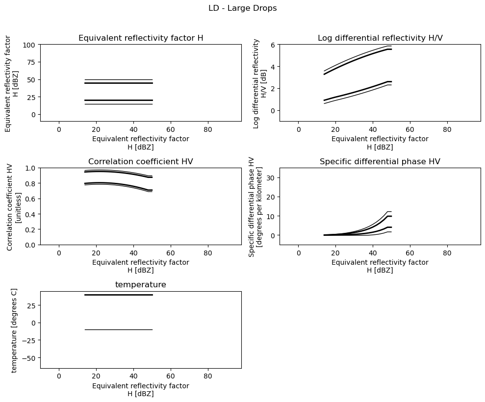
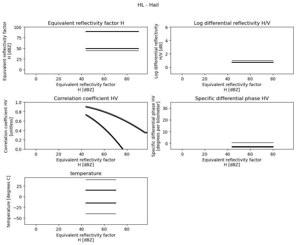
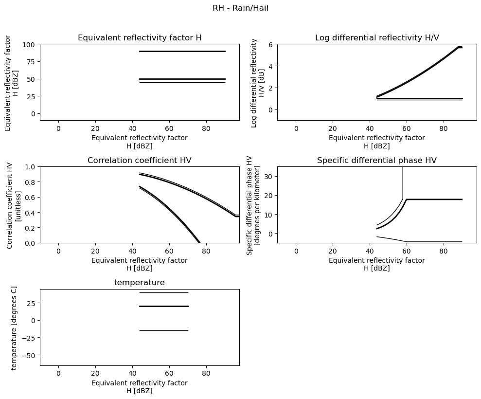
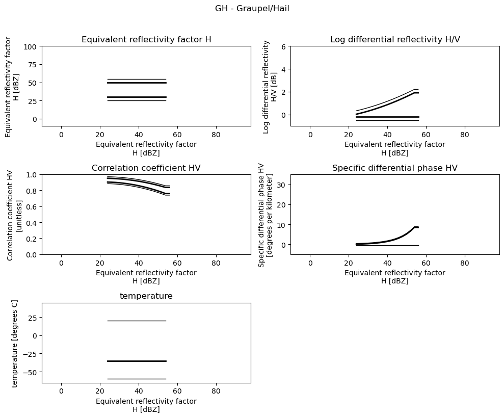
comment: created with wradlibPlot 2D Membership Functions#
[4]:
minmax = [(-10, 100), (-1, 6), (0.0, 1.0), (-5, 35), (-65, 45)]

for i, pr in enumerate(pr_types.values()):
    if pr[0] == "NP":
        continue
    fig = plt.figure(figsize=(10, 8))
    t = fig.suptitle(" - ".join(pr))
    t.set_y(1.02)
    hmc = msf.sel(hmc=pr[0])
    for k, p in enumerate(hmc.data_vars.values()):
        p = p.where(p != 0)
        ax = fig.add_subplot(3, 2, k + 1)
        p.sel(trapezoid=0).plot(x="idp", c="k", lw=1.0, ax=ax)
        p.sel(trapezoid=1).plot(x="idp", c="k", lw=2.0, ax=ax)
        p.sel(trapezoid=2).plot(x="idp", c="k", lw=2.0, ax=ax)
        p.sel(trapezoid=3).plot(x="idp", c="k", lw=1.0, ax=ax)
        ax.set_xlim((hmc.idp.min(), hmc.idp.max()))
        ax.margins(x=0.05, y=0.05)
        t = ax.set_title(f"{p.long_name}")
        ax.set_ylim(minmax[k])
    fig.tight_layout()
plt.show()
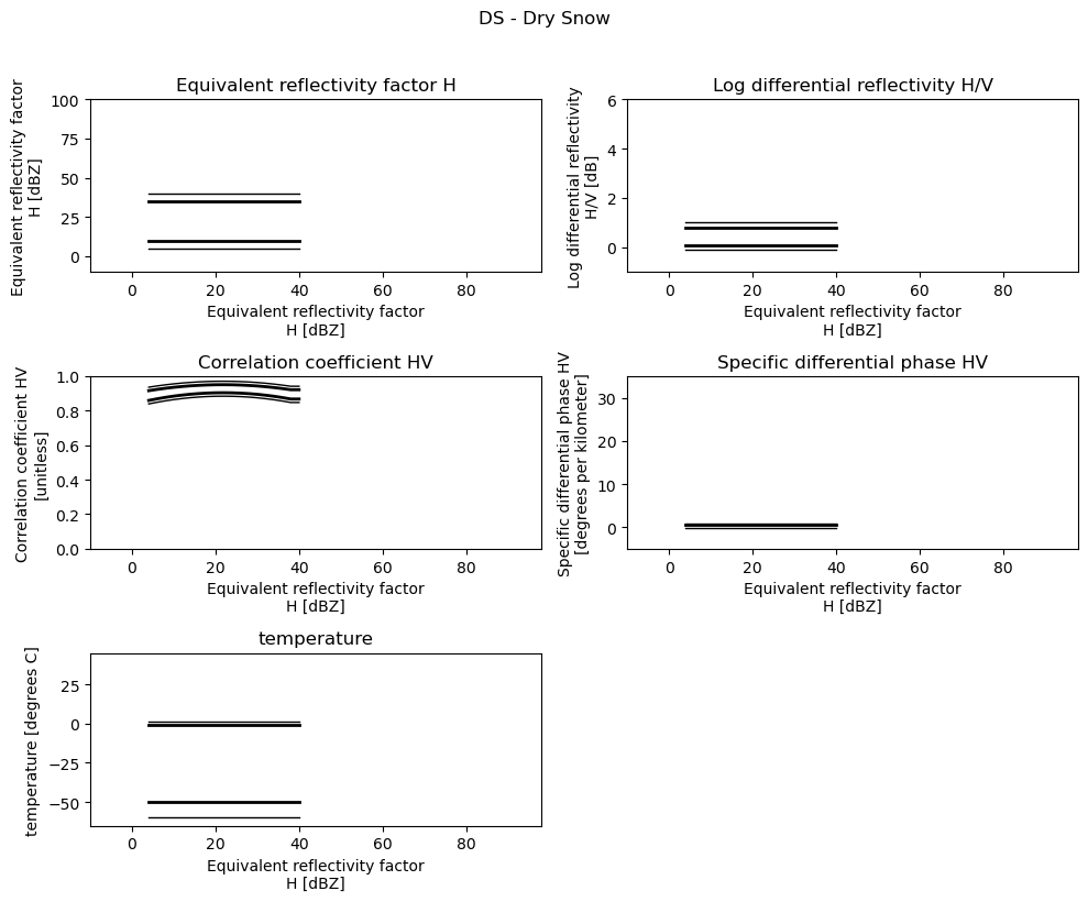
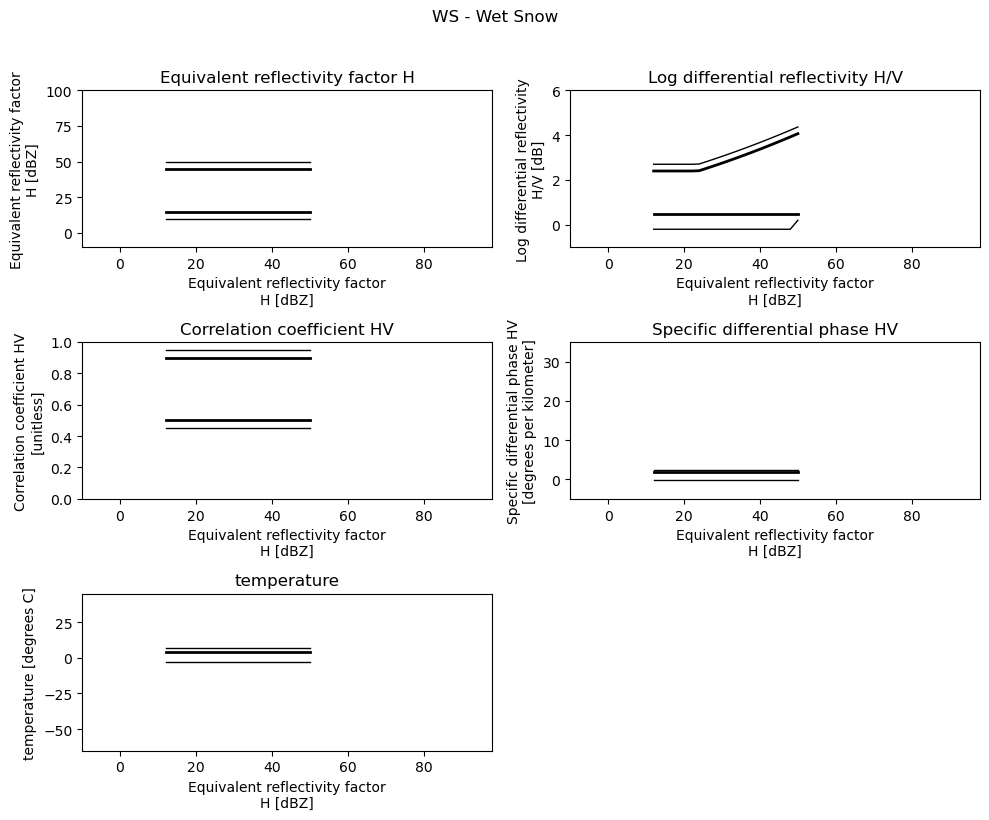
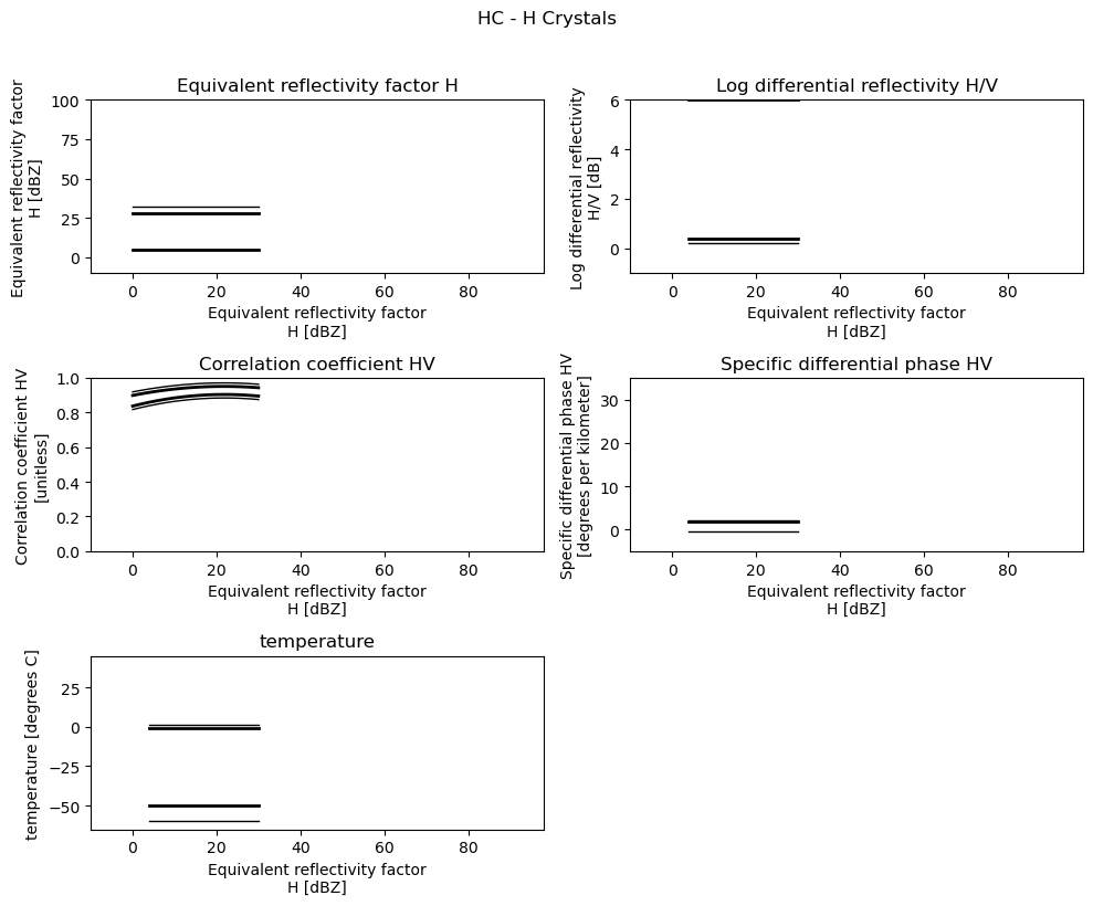
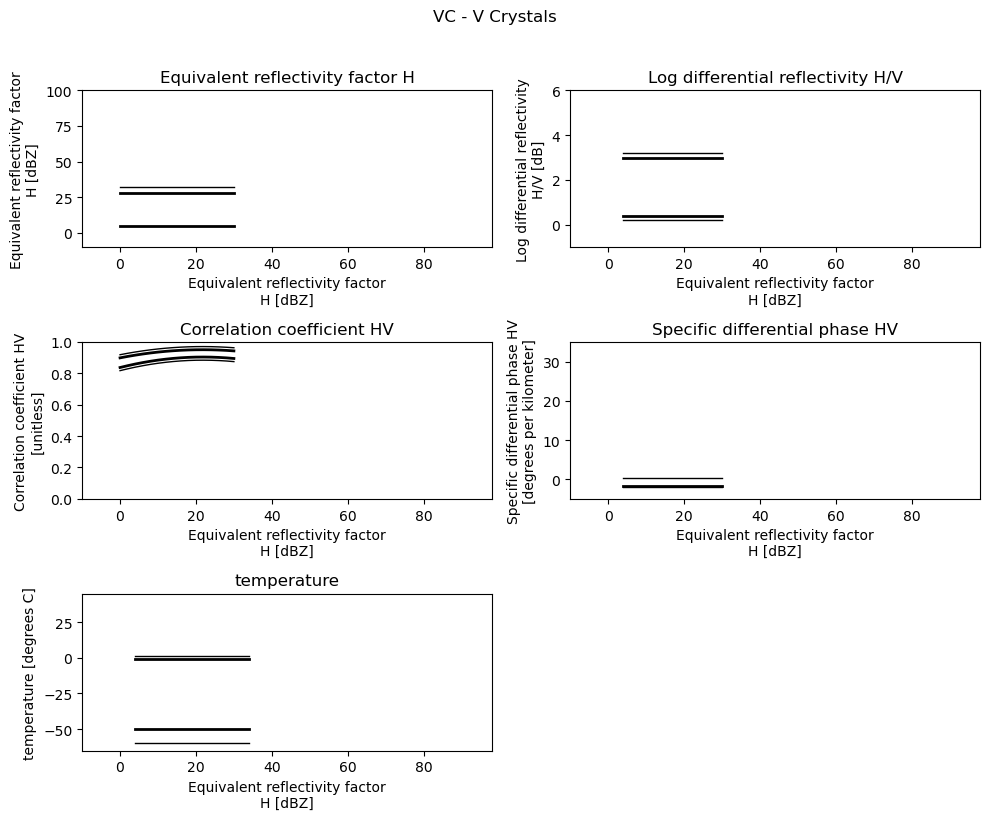
Use Sounding Data#
Retrieve Sounding Data#
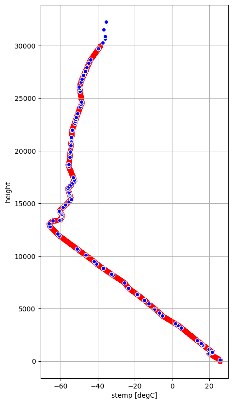
To get the temperature as additional discriminator we use radiosonde data from the University of Wyoming.
The function get_radiosonde tries to find the next next available radiosonde measurement on the given date.
[5]:
rs_time = dt.datetime(2014, 6, 10, 12, 0)
import urllib

try:
    rs_data, rs_meta = wrl.io.get_radiosonde(10410, rs_time)
except (urllib.error.HTTPError, urllib.error.URLError):
    dataf = wrl.util.get_wradlib_data_file("misc/radiosonde_10410_20140610_1200.h5")
    rs_data, _ = wrl.io.from_hdf5(dataf)
    metaf = wrl.util.get_wradlib_data_file("misc/radiosonde_10410_20140610_1200.json")
    with open(metaf, "r") as infile:
        import json

        rs_meta = json.load(infile)
rs_meta
[5]:
{'Station identifier': 'EDZE',
 'Station number': 10410,
 'Observation time': datetime.datetime(2014, 6, 10, 12, 0),
 'Station latitude': 51.4,
 'Station longitude': 6.97,
 'Station elevation': 147.0,
 'Showalter index': 1.65,
 'Lifted index': -5.85,
 'LIFT computed using virtual temperature': -6.24,
 'SWEAT index': 89.02,
 'K index': 23.7,
 'Cross totals index': 17.3,
 'Vertical totals index': 31.3,
 'Totals totals index': 48.6,
 'Convective Available Potential Energy': 1542.9,
 'CAPE using virtual temperature': 1644.44,
 'Convective Inhibition': -139.39,
 'CINS using virtual temperature': -79.9,
 'Equilibrum Level': 202.46,
 'Equilibrum Level using virtual temperature': 202.39,
 'Level of Free Convection': 736.36,
 'LFCT using virtual temperature': 773.09,
 'Bulk Richardson Number': 57.4,
 'Bulk Richardson Number using CAPV': 61.18,
 'Temp [K] of the Lifted Condensation Level': 288.22,
 'Pres [hPa] of the Lifted Condensation Level': 882.28,
 'Equivalent potential temp [K] of the LCL': 334.9,
 'Mean mixed layer potential temperature': 298.74,
 'Mean mixed layer mixing ratio': 12.42,
 '1000 hPa to 500 hPa thickness': 5663.0,
 'Precipitable water [mm] for entire sounding': 28.11,
 'quantity': {'PRES': 'hPa',
  'HGHT': 'm',
  'TEMP': 'C',
  'DWPT': 'C',
  'FRPT': 'C',
  'RELH': '%',
  'RELI': '%',
  'MIXR': 'g/kg',
  'DRCT': 'deg',
  'SKNT': 'knot',
  'THTA': 'K',
  'THTE': 'K',
  'THTV': 'K'}}
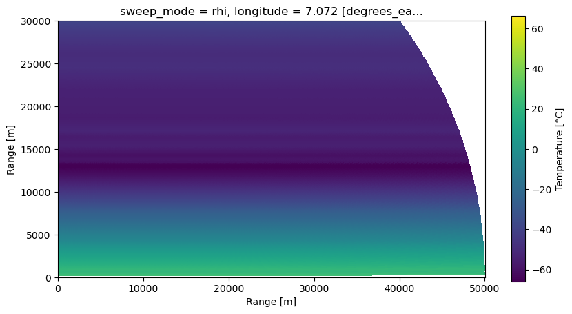
Extract Temperature and Height#
[6]:
stemp = rs_data["TEMP"]
sheight = rs_data["HGHT"]
# remove nans
idx = np.isfinite(stemp)
stemp = stemp[idx]
sheight = sheight[idx]
Create DataArray#
[7]:
stemp_da = xr.DataArray(
    data=stemp,
    dims=["height"],
    coords=dict(
        height=(["height"], sheight),
    ),
    attrs=dict(
        description="Temperature.",
        units="degC",
    ),
)
display(stemp_da)
<xarray.DataArray (height: 97)>
array([ 25.6,  19.8,  21.6,  21.6,  21.6,  19.7,  16.7,  16.4,  15.6,
        13.4,   5. ,   3.2,   1.8,  -5.3,  -6.7,  -9.3, -12.5, -14.9,
       -18.5, -18.9, -23.5, -25.5, -31.9, -32.7, -37. , -40.7, -41.9,
       -46.5, -50.5, -51.1, -60.7, -61.5, -65.7, -66.1, -64.1, -60.5,
       -59.1, -59.1, -59.4, -59.9, -60.4, -60.7, -58.5, -57.4, -55.5,
       -54.3, -54.9, -55.1, -55.3, -55.5, -55.9, -56.1, -55.4, -54.4,
       -53.4, -52.5, -52.7, -53.2, -55.6, -55.9, -55.5, -55.1, -54.9,
       -54.8, -54.6, -54.5, -54.3, -54.2, -54.2, -54.1, -53.9, -53.8,
       -52.5, -52.2, -51.8, -51.5, -50.7, -49.5, -48.9, -48.5, -48.6,
       -49.5, -49.7, -49.9, -49.1, -48.5, -47.6, -46.7, -45.8, -44.8,
       -43.9, -39.5, -37.3, -35.9, -36.1, -36.7, -35.5])
Coordinates:
  * height   (height) float64 147.0 744.0 828.0 ... 3.155e+04 3.228e+04
Attributes:
    description:  Temperature.
units: degCInterpolate to higher resolution#
[8]:
hmax = 30000.0
ht = np.arange(0.0, hmax)
itemp_da = stemp_da.interp({"height": ht})
display(itemp_da)
<xarray.DataArray (height: 30000)>
array([         nan,          nan,          nan, ..., -38.47842779,
       -38.47440585, -38.47038391])
Coordinates:
  * height   (height) float64 0.0 1.0 2.0 3.0 4.0 ... 3e+04 3e+04 3e+04 3e+04
Attributes:
    description:  Temperature.
units: degCFix Temperature below first measurement#
[9]:
itemp_da = itemp_da.bfill(dim="height")
Plot Temperature Profile#
[10]:
fig = plt.figure(figsize=(5, 10))
ax = fig.add_subplot(111)
itemp_da.plot(y="height", ax=ax, marker="o", zorder=0, c="r")
stemp_da.to_dataset(name="stemp").plot.scatter(
    x="stemp", y="height", ax=ax, marker="o", c="b", zorder=1
)
ax.grid(True)
Prepare Radar Data#
Load Radar Data#
[11]:
# read the radar volume scan
filename = "hdf5/2014-06-09--185000.rhi.mvol"
filename = wrl.util.get_wradlib_data_file(filename)
Downloading file 'hdf5/2014-06-09--185000.rhi.mvol' from 'https://github.com/wradlib/wradlib-data/raw/pooch/data/hdf5/2014-06-09--185000.rhi.mvol' to '/home/runner/work/wradlib/wradlib/wradlib-data'.
Extract data for georeferencing#
[12]:
import xradar as xd

swp = xr.open_dataset(
    filename, engine=xd.io.backends.GamicBackendEntrypoint, group="sweep_0", chunks={}
)
swp = xd.util.remove_duplicate_rays(swp)
swp = xd.util.reindex_angle(
    swp, start_angle=0, stop_angle=90, angle_res=0.2, direction=1
)
swp
[12]:
<xarray.Dataset>
Dimensions:            (range: 667, elevation: 450)
Coordinates:
  * range              (range) float32 37.5 112.5 187.5 ... 4.991e+04 4.999e+04
  * elevation          (elevation) float64 0.1 0.3 0.5 0.7 ... 89.5 89.7 89.9
    azimuth            (elevation) float64 dask.array<chunksize=(450,), meta=np.ndarray>
    time               (elevation) datetime64[ns] dask.array<chunksize=(450,), meta=np.ndarray>
    sweep_mode         <U3 ...
    longitude          float64 ...
    latitude           float64 ...
    altitude           float64 ...
Data variables: (12/16)
    KDP                (elevation, range) float32 dask.array<chunksize=(450, 667), meta=np.ndarray>
    PHIDP              (elevation, range) float32 dask.array<chunksize=(450, 667), meta=np.ndarray>
    DBZH               (elevation, range) float32 dask.array<chunksize=(450, 667), meta=np.ndarray>
    DBZV               (elevation, range) float32 dask.array<chunksize=(450, 667), meta=np.ndarray>
    RHOHV              (elevation, range) float32 dask.array<chunksize=(450, 667), meta=np.ndarray>
    DBTH               (elevation, range) float32 dask.array<chunksize=(450, 667), meta=np.ndarray>
    ...                 ...
    WRADV              (elevation, range) float32 dask.array<chunksize=(450, 667), meta=np.ndarray>
    ZDR                (elevation, range) float32 dask.array<chunksize=(450, 667), meta=np.ndarray>
    sweep_number       int64 ...
    prt_mode           <U7 ...
    follow_mode        <U7 ...
sweep_fixed_angle float64 ...[13]:
swp.azimuth.load(), swp.time.load()
[13]:
(<xarray.DataArray 'azimuth' (elevation: 450)>
 array([225.        , 225.        , 225.        , 225.00549316,
        405.00549316, 225.00549316, 405.00549316, 225.        ,
        225.00549316, 225.01098633, 405.00549316, 225.00549316,
        405.00549316, 225.00549316, 225.01098633, 225.01098633,
        405.00549316, 225.00549316, 405.00549316, 225.        ,
        225.00549316, 225.01098633, 405.00549316, 225.00549316,
        225.01098633, 405.00549316, 225.        , 225.01098633,
        225.        , 225.        , 225.        , 225.        ,
        225.        , 225.        , 225.00549316, 225.01098633,
        405.00549316, 225.00549316, 225.01098633, 405.00549316,
        225.00549316, 405.00549316, 225.00549316, 225.00549316,
        405.00549316, 225.00549316, 405.00549316, 225.        ,
        225.00549316, 405.00549316, 225.        , 225.        ,
        225.00549316, 405.00549316, 225.00549316, 405.00549316,
        225.        , 225.        , 225.        , 225.        ,
        225.00549316, 225.        , 225.        , 225.        ,
        225.        , 225.00549316, 405.00549316, 225.00549316,
        225.01098633, 405.00549316, 225.        , 225.        ,
        225.        , 225.        , 225.        , 225.        ,
        225.        , 225.        , 225.        , 225.        ,
 ...
        224.98901367, 224.98901367, 224.98901367, 224.98901367,
        224.98901367, 224.98901367, 224.98901367, 224.98901367,
        224.98901367, 224.98901367, 224.98901367, 224.98901367,
        224.98901367, 224.98901367, 224.98901367, 224.98901367,
        224.98901367, 224.98901367, 224.98901367, 224.98901367,
        224.98901367, 224.98901367, 224.98901367, 224.98901367,
        224.98901367, 224.98901367, 224.98901367, 224.98901367,
        224.98901367, 224.98901367, 224.98901367, 224.98901367,
        224.98901367, 224.98901367, 224.98901367, 224.98901367,
        224.98901367, 224.98901367, 224.98901367, 224.98901367,
        224.98901367, 224.98901367, 224.98901367, 224.98901367,
        224.98901367, 224.98901367, 224.98901367, 224.98901367,
        224.98901367, 224.98901367, 224.98901367, 224.98901367,
        224.98901367, 224.98901367, 224.98901367, 224.98901367,
        224.98901367, 224.98901367, 224.98901367, 224.98901367,
        224.98901367, 224.98901367, 224.98901367, 224.98901367,
        224.98901367, 224.98901367, 224.98901367, 224.98901367,
        224.98901367, 224.98901367, 224.98901367, 224.98901367,
        224.98901367, 224.98901367, 224.98901367, 224.98901367,
        224.98901367, 224.98901367])
 Coordinates:
   * elevation   (elevation) float64 0.1 0.3 0.5 0.7 0.9 ... 89.3 89.5 89.7 89.9
     azimuth     (elevation) float64 225.0 225.0 225.0 ... 225.0 225.0 225.0
     time        (elevation) datetime64[ns] 2014-06-09T18:50:01 ... 2014-06-09...
     sweep_mode  <U3 'rhi'
     longitude   float64 7.072
     latitude    float64 50.73
     altitude    float64 99.5
 Attributes:
     standard_name:  ray_azimuth_angle
     long_name:      azimuth_angle_from_true_north
     units:          degrees
     axis:           radial_azimuth_coordinate,
 <xarray.DataArray 'time' (elevation: 450)>
 array(['2014-06-09T18:50:01.000000000', '2014-06-09T18:50:04.000000000',
        '2014-06-09T18:50:04.000000000', '2014-06-09T18:50:04.000000000',
        '2014-06-09T18:50:04.000000000', '2014-06-09T18:50:04.000000000',
        '2014-06-09T18:50:04.000000000', '2014-06-09T18:50:04.000000000',
        '2014-06-09T18:50:04.000000000', '2014-06-09T18:50:04.000000000',
        '2014-06-09T18:50:04.000000000', '2014-06-09T18:50:04.000000000',
        '2014-06-09T18:50:04.000000000', '2014-06-09T18:50:04.000000000',
        '2014-06-09T18:50:04.000000000', '2014-06-09T18:50:04.000000000',
        '2014-06-09T18:50:04.000000000', '2014-06-09T18:50:04.000000000',
        '2014-06-09T18:50:05.000000000', '2014-06-09T18:50:05.000000000',
        '2014-06-09T18:50:05.000000000', '2014-06-09T18:50:05.000000000',
        '2014-06-09T18:50:05.000000000', '2014-06-09T18:50:05.000000000',
        '2014-06-09T18:50:05.000000000', '2014-06-09T18:50:05.000000000',
        '2014-06-09T18:50:05.000000000', '2014-06-09T18:50:05.000000000',
        '2014-06-09T18:50:05.000000000', '2014-06-09T18:50:05.000000000',
        '2014-06-09T18:50:05.000000000', '2014-06-09T18:50:05.000000000',
        '2014-06-09T18:50:05.000000000', '2014-06-09T18:50:05.000000000',
        '2014-06-09T18:50:05.000000000', '2014-06-09T18:50:05.000000000',
        '2014-06-09T18:50:05.000000000', '2014-06-09T18:50:05.000000000',
        '2014-06-09T18:50:06.000000000', '2014-06-09T18:50:06.000000000',
 ...
        '2014-06-09T18:50:24.000000000', '2014-06-09T18:50:24.000000000',
        '2014-06-09T18:50:24.000000000', '2014-06-09T18:50:24.000000000',
        '2014-06-09T18:50:25.000000000', '2014-06-09T18:50:25.000000000',
        '2014-06-09T18:50:25.000000000', '2014-06-09T18:50:25.000000000',
        '2014-06-09T18:50:25.000000000', '2014-06-09T18:50:25.000000000',
        '2014-06-09T18:50:25.000000000', '2014-06-09T18:50:25.000000000',
        '2014-06-09T18:50:25.000000000', '2014-06-09T18:50:25.000000000',
        '2014-06-09T18:50:25.000000000', '2014-06-09T18:50:25.000000000',
        '2014-06-09T18:50:25.000000000', '2014-06-09T18:50:25.000000000',
        '2014-06-09T18:50:25.000000000', '2014-06-09T18:50:25.000000000',
        '2014-06-09T18:50:25.000000000', '2014-06-09T18:50:25.000000000',
        '2014-06-09T18:50:25.000000000', '2014-06-09T18:50:25.000000000',
        '2014-06-09T18:50:26.000000000', '2014-06-09T18:50:26.000000000',
        '2014-06-09T18:50:26.000000000', '2014-06-09T18:50:26.000000000',
        '2014-06-09T18:50:26.000000000', '2014-06-09T18:50:26.000000000',
        '2014-06-09T18:50:26.000000000', '2014-06-09T18:50:26.000000000',
        '2014-06-09T18:50:26.000000000', '2014-06-09T18:50:26.000000000',
        '2014-06-09T18:50:26.000000000', '2014-06-09T18:50:26.000000000',
        '2014-06-09T18:50:26.000000000', '2014-06-09T18:50:27.000000000'],
       dtype='datetime64[ns]')
 Coordinates:
   * elevation   (elevation) float64 0.1 0.3 0.5 0.7 0.9 ... 89.3 89.5 89.7 89.9
     azimuth     (elevation) float64 225.0 225.0 225.0 ... 225.0 225.0 225.0
     time        (elevation) datetime64[ns] 2014-06-09T18:50:01 ... 2014-06-09...
     sweep_mode  <U3 'rhi'
     longitude   float64 7.072
     latitude    float64 50.73
     altitude    float64 99.5
 Attributes:
     standard_name:  time)
[14]:
swp.azimuth.values
[14]:
array([225.        , 225.        , 225.        , 225.00549316,
       405.00549316, 225.00549316, 405.00549316, 225.        ,
       225.00549316, 225.01098633, 405.00549316, 225.00549316,
       405.00549316, 225.00549316, 225.01098633, 225.01098633,
       405.00549316, 225.00549316, 405.00549316, 225.        ,
       225.00549316, 225.01098633, 405.00549316, 225.00549316,
       225.01098633, 405.00549316, 225.        , 225.01098633,
       225.        , 225.        , 225.        , 225.        ,
       225.        , 225.        , 225.00549316, 225.01098633,
       405.00549316, 225.00549316, 225.01098633, 405.00549316,
       225.00549316, 405.00549316, 225.00549316, 225.00549316,
       405.00549316, 225.00549316, 405.00549316, 225.        ,
       225.00549316, 405.00549316, 225.        , 225.        ,
       225.00549316, 405.00549316, 225.00549316, 405.00549316,
       225.        , 225.        , 225.        , 225.        ,
       225.00549316, 225.        , 225.        , 225.        ,
       225.        , 225.00549316, 405.00549316, 225.00549316,
       225.01098633, 405.00549316, 225.        , 225.        ,
       225.        , 225.        , 225.        , 225.        ,
       225.        , 225.        , 225.        , 225.        ,
       225.        , 225.00549316, 405.00549316, 225.        ,
       225.        , 225.00549316, 225.01098633, 405.00549316,
       225.00549316, 225.01098633, 405.00549316, 225.        ,
       225.        , 225.        , 225.00549316, 405.00549316,
       225.00549316, 405.00549316, 225.        , 225.        ,
       225.        , 225.        , 225.        , 225.        ,
       225.        , 225.        , 225.        , 225.        ,
       225.        , 225.        , 225.00549316, 225.01098633,
       405.00549316, 225.        , 225.00549316, 225.01098633,
       405.00549316, 405.00549316, 225.        , 225.00549316,
       405.00549316, 225.        , 225.        , 225.        ,
       225.        , 225.        , 225.        , 225.        ,
       404.99450684, 404.98352051, 224.98352051, 224.98901367,
       224.98901367, 224.98901367, 224.98901367, 224.98901367,
       224.98901367, 224.98901367, 224.98901367, 224.98901367,
       224.98901367, 224.98901367, 224.98901367, 224.98901367,
       224.98901367, 224.98901367, 224.98901367, 224.98901367,
       224.98901367, 224.98901367, 224.98901367, 224.98901367,
       224.98901367, 224.98901367, 224.98901367, 224.98901367,
       224.98901367, 224.98901367, 224.98901367, 224.98901367,
       224.98901367, 224.98901367, 224.98901367, 224.98901367,
       224.98901367, 224.98901367, 224.98901367, 224.98901367,
       224.98901367, 224.98901367, 224.98901367, 224.98901367,
       224.98901367, 224.98901367, 224.98901367, 224.98901367,
       224.98901367, 224.98901367, 224.98901367, 224.98901367,
       224.98901367, 224.98901367, 224.98901367, 224.98901367,
       224.98901367, 224.98901367, 224.98901367, 224.98901367,
       224.98901367, 224.98901367, 224.98901367, 224.98901367,
       224.98901367, 224.98901367, 224.98901367, 224.98901367,
       224.98901367, 224.98901367, 224.98901367, 224.98901367,
       224.98901367, 224.98901367, 224.98901367, 224.98901367,
       224.98901367, 224.98901367, 224.98901367, 224.98901367,
       224.98901367, 224.98901367, 224.98901367, 224.98901367,
       224.98901367, 224.98901367, 224.98901367, 224.98901367,
       224.98901367, 224.98901367, 224.98901367, 224.98901367,
       224.98901367, 224.98901367, 224.98901367, 224.98901367,
       224.98901367, 224.98901367, 224.98901367, 224.98901367,
       224.98901367, 224.98901367, 224.98901367, 224.98901367,
       224.98901367, 224.98901367, 224.98901367, 224.98901367,
       224.98901367, 224.98901367, 224.98901367, 224.98901367,
       224.98901367, 224.98901367, 224.98901367, 224.98901367,
       224.98901367, 224.98901367, 224.98901367, 224.98901367,
       224.98901367, 224.98901367, 224.98901367, 224.98901367,
       224.98901367, 224.98901367, 224.98901367, 224.98901367,
       224.98901367, 224.98901367, 224.98901367, 224.98901367,
       224.98901367, 224.98901367, 224.98901367, 224.98901367,
       224.98901367, 224.98901367, 224.98901367, 224.98901367,
       224.98901367, 224.98901367, 224.98901367, 224.98901367,
       224.98901367, 224.98901367, 224.98901367, 224.98901367,
       224.98901367, 224.98901367, 224.98901367, 224.98901367,
       224.98901367, 224.98901367, 224.98901367, 224.98901367,
       224.98901367, 224.98901367, 224.98901367, 224.98901367,
       224.98901367, 224.98901367, 224.98901367, 224.98901367,
       224.98901367, 224.98901367, 224.98901367, 224.98901367,
       224.99450684, 404.99450684, 224.98901367, 224.98901367,
       224.98901367, 224.98901367, 224.98901367, 224.98901367,
       224.98901367, 224.98901367, 224.98901367, 224.98901367,
       224.98901367, 224.98901367, 224.98901367, 224.98901367,
       224.98901367, 224.98901367, 224.98901367, 224.98901367,
       224.98901367, 224.98901367, 224.98901367, 224.98901367,
       224.98901367, 224.98901367, 224.98901367, 224.98901367,
       224.98901367, 224.98901367, 224.98901367, 224.98901367,
       224.98901367, 224.98901367, 224.98901367, 224.98901367,
       224.98901367, 224.98901367, 224.98901367, 224.98901367,
       224.98901367, 224.98901367, 224.98901367, 224.98901367,
       224.98901367, 224.98901367, 224.98901367, 224.98901367,
       224.98901367, 224.98901367, 224.98901367, 224.98901367,
       224.98901367, 224.98901367, 224.98901367, 224.98901367,
       224.98901367, 224.98901367, 224.98901367, 224.98901367,
       224.98901367, 224.98901367, 224.98901367, 224.98901367,
       224.98901367, 224.98901367, 224.98901367, 224.98901367,
       224.98901367, 224.98901367, 224.98901367, 224.98901367,
       224.98901367, 224.98901367, 224.98901367, 224.98901367,
       224.98901367, 224.98901367, 224.98901367, 224.98901367,
       224.98901367, 224.98901367, 224.98901367, 224.98901367,
       224.98901367, 224.98901367, 224.98901367, 224.98901367,
       224.98901367, 224.98901367, 224.98901367, 224.98901367,
       224.98901367, 224.98901367, 224.98901367, 224.98901367,
       224.98901367, 224.98901367, 224.98901367, 224.98901367,
       224.98901367, 224.98901367, 224.98901367, 224.98901367,
       224.98901367, 224.98901367, 224.98901367, 224.98901367,
       224.98901367, 224.98901367, 224.98901367, 224.98901367,
       224.98901367, 224.98901367, 224.98901367, 224.98901367,
       224.98901367, 224.98901367, 224.98901367, 224.98901367,
       224.98901367, 224.98901367, 224.98901367, 224.98901367,
       224.98901367, 224.98901367, 224.98901367, 224.98901367,
       224.98901367, 224.98901367, 224.98901367, 224.98901367,
       224.98901367, 224.98901367, 224.98901367, 224.98901367,
       224.98901367, 224.98901367, 224.98901367, 224.98901367,
       224.98901367, 224.98901367, 224.98901367, 224.98901367,
       224.98901367, 224.98901367, 224.98901367, 224.98901367,
       224.98901367, 224.98901367, 224.98901367, 224.98901367,
       224.98901367, 224.98901367])
Get Heights of Radar Bins#
[15]:
swp = swp.wrl.georef.georeference()
swp.azimuth.values
[15]:
array([225.        , 225.        , 225.        , 225.00549316,
       405.00549316, 225.00549316, 405.00549316, 225.        ,
       225.00549316, 225.01098633, 405.00549316, 225.00549316,
       405.00549316, 225.00549316, 225.01098633, 225.01098633,
       405.00549316, 225.00549316, 405.00549316, 225.        ,
       225.00549316, 225.01098633, 405.00549316, 225.00549316,
       225.01098633, 405.00549316, 225.        , 225.01098633,
       225.        , 225.        , 225.        , 225.        ,
       225.        , 225.        , 225.00549316, 225.01098633,
       405.00549316, 225.00549316, 225.01098633, 405.00549316,
       225.00549316, 405.00549316, 225.00549316, 225.00549316,
       405.00549316, 225.00549316, 405.00549316, 225.        ,
       225.00549316, 405.00549316, 225.        , 225.        ,
       225.00549316, 405.00549316, 225.00549316, 405.00549316,
       225.        , 225.        , 225.        , 225.        ,
       225.00549316, 225.        , 225.        , 225.        ,
       225.        , 225.00549316, 405.00549316, 225.00549316,
       225.01098633, 405.00549316, 225.        , 225.        ,
       225.        , 225.        , 225.        , 225.        ,
       225.        , 225.        , 225.        , 225.        ,
       225.        , 225.00549316, 405.00549316, 225.        ,
       225.        , 225.00549316, 225.01098633, 405.00549316,
       225.00549316, 225.01098633, 405.00549316, 225.        ,
       225.        , 225.        , 225.00549316, 405.00549316,
       225.00549316, 405.00549316, 225.        , 225.        ,
       225.        , 225.        , 225.        , 225.        ,
       225.        , 225.        , 225.        , 225.        ,
       225.        , 225.        , 225.00549316, 225.01098633,
       405.00549316, 225.        , 225.00549316, 225.01098633,
       405.00549316, 405.00549316, 225.        , 225.00549316,
       405.00549316, 225.        , 225.        , 225.        ,
       225.        , 225.        , 225.        , 225.        ,
       404.99450684, 404.98352051, 224.98352051, 224.98901367,
       224.98901367, 224.98901367, 224.98901367, 224.98901367,
       224.98901367, 224.98901367, 224.98901367, 224.98901367,
       224.98901367, 224.98901367, 224.98901367, 224.98901367,
       224.98901367, 224.98901367, 224.98901367, 224.98901367,
       224.98901367, 224.98901367, 224.98901367, 224.98901367,
       224.98901367, 224.98901367, 224.98901367, 224.98901367,
       224.98901367, 224.98901367, 224.98901367, 224.98901367,
       224.98901367, 224.98901367, 224.98901367, 224.98901367,
       224.98901367, 224.98901367, 224.98901367, 224.98901367,
       224.98901367, 224.98901367, 224.98901367, 224.98901367,
       224.98901367, 224.98901367, 224.98901367, 224.98901367,
       224.98901367, 224.98901367, 224.98901367, 224.98901367,
       224.98901367, 224.98901367, 224.98901367, 224.98901367,
       224.98901367, 224.98901367, 224.98901367, 224.98901367,
       224.98901367, 224.98901367, 224.98901367, 224.98901367,
       224.98901367, 224.98901367, 224.98901367, 224.98901367,
       224.98901367, 224.98901367, 224.98901367, 224.98901367,
       224.98901367, 224.98901367, 224.98901367, 224.98901367,
       224.98901367, 224.98901367, 224.98901367, 224.98901367,
       224.98901367, 224.98901367, 224.98901367, 224.98901367,
       224.98901367, 224.98901367, 224.98901367, 224.98901367,
       224.98901367, 224.98901367, 224.98901367, 224.98901367,
       224.98901367, 224.98901367, 224.98901367, 224.98901367,
       224.98901367, 224.98901367, 224.98901367, 224.98901367,
       224.98901367, 224.98901367, 224.98901367, 224.98901367,
       224.98901367, 224.98901367, 224.98901367, 224.98901367,
       224.98901367, 224.98901367, 224.98901367, 224.98901367,
       224.98901367, 224.98901367, 224.98901367, 224.98901367,
       224.98901367, 224.98901367, 224.98901367, 224.98901367,
       224.98901367, 224.98901367, 224.98901367, 224.98901367,
       224.98901367, 224.98901367, 224.98901367, 224.98901367,
       224.98901367, 224.98901367, 224.98901367, 224.98901367,
       224.98901367, 224.98901367, 224.98901367, 224.98901367,
       224.98901367, 224.98901367, 224.98901367, 224.98901367,
       224.98901367, 224.98901367, 224.98901367, 224.98901367,
       224.98901367, 224.98901367, 224.98901367, 224.98901367,
       224.98901367, 224.98901367, 224.98901367, 224.98901367,
       224.98901367, 224.98901367, 224.98901367, 224.98901367,
       224.98901367, 224.98901367, 224.98901367, 224.98901367,
       224.98901367, 224.98901367, 224.98901367, 224.98901367,
       224.98901367, 224.98901367, 224.98901367, 224.98901367,
       224.99450684, 404.99450684, 224.98901367, 224.98901367,
       224.98901367, 224.98901367, 224.98901367, 224.98901367,
       224.98901367, 224.98901367, 224.98901367, 224.98901367,
       224.98901367, 224.98901367, 224.98901367, 224.98901367,
       224.98901367, 224.98901367, 224.98901367, 224.98901367,
       224.98901367, 224.98901367, 224.98901367, 224.98901367,
       224.98901367, 224.98901367, 224.98901367, 224.98901367,
       224.98901367, 224.98901367, 224.98901367, 224.98901367,
       224.98901367, 224.98901367, 224.98901367, 224.98901367,
       224.98901367, 224.98901367, 224.98901367, 224.98901367,
       224.98901367, 224.98901367, 224.98901367, 224.98901367,
       224.98901367, 224.98901367, 224.98901367, 224.98901367,
       224.98901367, 224.98901367, 224.98901367, 224.98901367,
       224.98901367, 224.98901367, 224.98901367, 224.98901367,
       224.98901367, 224.98901367, 224.98901367, 224.98901367,
       224.98901367, 224.98901367, 224.98901367, 224.98901367,
       224.98901367, 224.98901367, 224.98901367, 224.98901367,
       224.98901367, 224.98901367, 224.98901367, 224.98901367,
       224.98901367, 224.98901367, 224.98901367, 224.98901367,
       224.98901367, 224.98901367, 224.98901367, 224.98901367,
       224.98901367, 224.98901367, 224.98901367, 224.98901367,
       224.98901367, 224.98901367, 224.98901367, 224.98901367,
       224.98901367, 224.98901367, 224.98901367, 224.98901367,
       224.98901367, 224.98901367, 224.98901367, 224.98901367,
       224.98901367, 224.98901367, 224.98901367, 224.98901367,
       224.98901367, 224.98901367, 224.98901367, 224.98901367,
       224.98901367, 224.98901367, 224.98901367, 224.98901367,
       224.98901367, 224.98901367, 224.98901367, 224.98901367,
       224.98901367, 224.98901367, 224.98901367, 224.98901367,
       224.98901367, 224.98901367, 224.98901367, 224.98901367,
       224.98901367, 224.98901367, 224.98901367, 224.98901367,
       224.98901367, 224.98901367, 224.98901367, 224.98901367,
       224.98901367, 224.98901367, 224.98901367, 224.98901367,
       224.98901367, 224.98901367, 224.98901367, 224.98901367,
       224.98901367, 224.98901367, 224.98901367, 224.98901367,
       224.98901367, 224.98901367, 224.98901367, 224.98901367,
       224.98901367, 224.98901367, 224.98901367, 224.98901367,
       224.98901367, 224.98901367, 224.98901367, 224.98901367,
       224.98901367, 224.98901367])
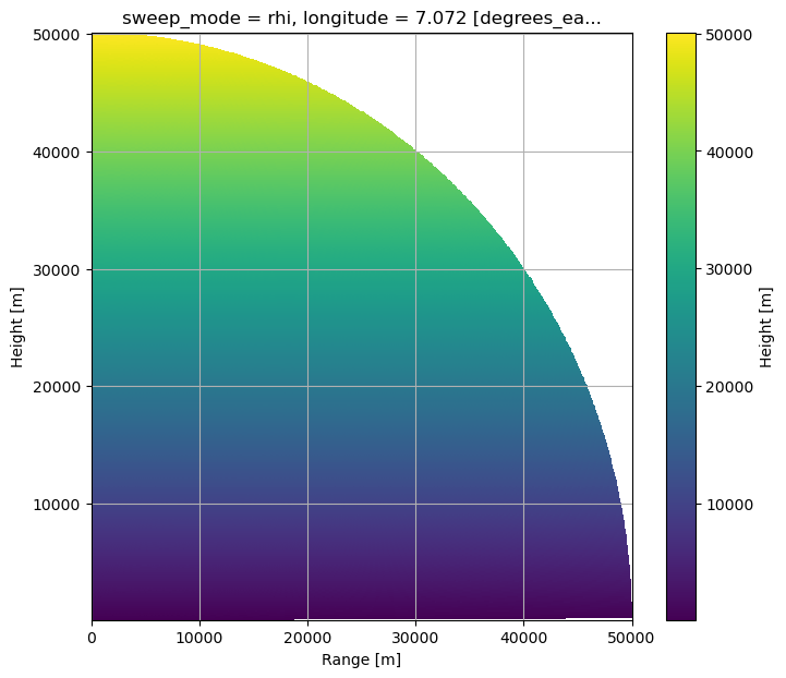
Plot RHI of Heights#
[16]:
fig = plt.figure(figsize=(8, 7))
ax = fig.add_subplot(111)
cmap = mpl.cm.viridis
swp.z.plot(x="gr", y="z", ax=ax, cbar_kwargs=dict(label="Height [m]"))
ax.set_xlabel("Range [m]")
ax.set_ylabel("Height [m]")
ax.grid(True)
plt.show()
Get Index into High Res Height Array#
[17]:
def merge_radar_profile(rds, cds):
    cds = cds.interp({"height": rds.z}, method="linear")
    rds = rds.assign({"TEMP": cds})
    return rds
[18]:
hmc_ds = swp.pipe(merge_radar_profile, itemp_da)
display(hmc_ds)
<xarray.Dataset>
Dimensions:            (range: 667, elevation: 450)
Coordinates: (12/16)
  * range              (range) float32 37.5 112.5 187.5 ... 4.991e+04 4.999e+04
  * elevation          (elevation) float64 0.1 0.3 0.5 0.7 ... 89.5 89.7 89.9
    azimuth            (elevation) float64 225.0 225.0 225.0 ... 225.0 225.0
    time               (elevation) datetime64[ns] 2014-06-09T18:50:01 ... 201...
    sweep_mode         <U3 'rhi'
    longitude          float64 7.072
    ...                 ...
    z                  (elevation, range) float64 99.63 99.76 ... 5.009e+04
    gr                 (elevation, range) float64 18.39 93.39 ... 67.49 67.62
    rays               (elevation, range) float64 0.1 0.1 0.1 ... 89.9 89.9 89.9
    bins               (elevation, range) float32 37.5 112.5 ... 4.999e+04
    crs_wkt            int64 0
    height             (elevation, range) float64 99.63 99.76 ... 5.009e+04
Data variables: (12/17)
    KDP                (elevation, range) float32 dask.array<chunksize=(450, 667), meta=np.ndarray>
    PHIDP              (elevation, range) float32 dask.array<chunksize=(450, 667), meta=np.ndarray>
    DBZH               (elevation, range) float32 dask.array<chunksize=(450, 667), meta=np.ndarray>
    DBZV               (elevation, range) float32 dask.array<chunksize=(450, 667), meta=np.ndarray>
    RHOHV              (elevation, range) float32 dask.array<chunksize=(450, 667), meta=np.ndarray>
    DBTH               (elevation, range) float32 dask.array<chunksize=(450, 667), meta=np.ndarray>
    ...                 ...
    ZDR                (elevation, range) float32 dask.array<chunksize=(450, 667), meta=np.ndarray>
    sweep_number       int64 ...
    prt_mode           <U7 ...
    follow_mode        <U7 ...
    sweep_fixed_angle  float64 ...
TEMP (elevation, range) float64 25.6 25.6 25.6 ... nan nan nan[19]:
fig = plt.figure(figsize=(10, 5))
ax = fig.add_subplot(111)
hmc_ds.TEMP.plot(
    x="gr",
    y="z",
    cmap=cmap,
    ax=ax,
    add_colorbar=True,
    cbar_kwargs=dict(label="Temperature [°C]"),
)
ax.set_xlabel("Range [m]")
ax.set_ylabel("Range [m]")
ax.set_aspect("equal")
ax.set_ylim(0, 30000)
plt.show()
HMC Workflow#
Setup Independent Observable \(Z_H\)#
Retrieve membership function values based on independent observable
[20]:
%%time
msf_val = msf.wrl.classify.msf_index_indep(swp.DBZH)
display(msf_val)
<xarray.DataArray 'msf_index_indep' (hmc: 11, obs: 5, elevation: 450,
                                     range: 667, trapezoid: 4)>
dask.array<transpose, shape=(11, 5, 450, 667, 4), dtype=int32, chunksize=(11, 5, 450, 667, 4), chunktype=numpy.ndarray>
Coordinates: (12/17)
  * hmc         (hmc) object 'LR' 'MR' 'HR' 'LD' 'HL' ... 'DS' 'WS' 'HC' 'VC'
  * obs         (obs) object 'ZH' 'ZDR' 'RHO' 'KDP' 'TEMP'
  * range       (range) float32 37.5 112.5 187.5 ... 4.991e+04 4.999e+04
  * elevation   (elevation) float64 0.1 0.3 0.5 0.7 0.9 ... 89.3 89.5 89.7 89.9
    azimuth     (elevation) float64 225.0 225.0 225.0 ... 225.0 225.0 225.0
    time        (elevation) datetime64[ns] 2014-06-09T18:50:01 ... 2014-06-09...
    ...          ...
    y           (elevation, range) float64 -26.52 -79.55 ... -61.25 -61.34
    z           (elevation, range) float64 99.63 99.76 ... 5.001e+04 5.009e+04
    gr          (elevation, range) float64 18.39 93.39 168.4 ... 67.49 67.62
    rays        (elevation, range) float64 0.1 0.1 0.1 0.1 ... 89.9 89.9 89.9
    bins        (elevation, range) float32 37.5 112.5 ... 4.991e+04 4.999e+04
    crs_wkt     int64 0
Dimensions without coordinates: trapezoid
CPU times: user 45.7 ms, sys: 3.86 ms, total: 49.5 ms
Wall time: 51.6 ms
Fuzzyfication#
[21]:
%%time
fu = msf_val.wrl.classify.fuzzyfi(
    hmc_ds, dict(ZH="DBZH", ZDR="ZDR", RHO="RHOHV", KDP="KDP", TEMP="TEMP")
)
CPU times: user 13.6 ms, sys: 0 ns, total: 13.6 ms
Wall time: 13.4 ms
Probability#
[22]:
# weights dataset
w = xr.Dataset(dict(ZH=2.0, ZDR=1.0, RHO=1.0, KDP=1.0, TEMP=1.0))
display(w)
<xarray.Dataset>
Dimensions:  ()
Data variables:
    ZH       float64 2.0
    ZDR      float64 1.0
    RHO      float64 1.0
    KDP      float64 1.0
TEMP float64 1.0[23]:
%%time
prob = fu.wrl.classify.probability(w).compute()
display(prob)
<xarray.DataArray (hmc: 11, elevation: 450, range: 667)>
array([[[0.16666667, 0.5       , 0.5       , ..., 0.        ,
         0.        , 0.        ],
        [0.        , 0.5       , 0.66666667, ..., 0.        ,
         0.        , 0.        ],
        [0.        , 0.5       , 0.5       , ..., 0.        ,
         0.        , 0.        ],
        ...,
        [0.16666667, 0.66666667, 0.5       , ..., 0.        ,
         0.        , 0.        ],
        [0.16666667, 0.66666667, 0.5       , ..., 0.        ,
         0.        , 0.        ],
        [0.16666667, 0.66666667, 0.5       , ..., 0.        ,
         0.        , 0.        ]],

       [[0.        , 0.        , 0.        , ..., 0.        ,
         0.        , 0.        ],
        [0.        , 0.        , 0.        , ..., 0.        ,
         0.        , 0.        ],
        [0.        , 0.        , 0.        , ..., 0.        ,
         0.        , 0.        ],
...
        [0.29812113, 0.33333333, 0.33333333, ..., 0.        ,
         0.        , 0.        ],
        [0.31296539, 0.33333333, 0.33333333, ..., 0.        ,
         0.        , 0.        ],
        [0.32917684, 0.33333333, 0.33333333, ..., 0.        ,
         0.        , 0.        ]],

       [[0.29480082, 0.33333333, 0.33333333, ..., 0.        ,
         0.        , 0.        ],
        [0.25280711, 0.33333333, 0.33333333, ..., 0.        ,
         0.        , 0.        ],
        [0.25808055, 0.33333333, 0.33333333, ..., 0.        ,
         0.        , 0.        ],
        ...,
        [0.29812113, 0.33333333, 0.33333333, ..., 0.        ,
         0.        , 0.        ],
        [0.31296539, 0.33333333, 0.33333333, ..., 0.        ,
         0.        , 0.        ],
        [0.32917684, 0.33333333, 0.33333333, ..., 0.        ,
         0.        , 0.        ]]])
Coordinates: (12/17)
  * hmc         (hmc) object 'LR' 'MR' 'HR' 'LD' 'HL' ... 'DS' 'WS' 'HC' 'VC'
  * range       (range) float32 37.5 112.5 187.5 ... 4.991e+04 4.999e+04
  * elevation   (elevation) float64 0.1 0.3 0.5 0.7 0.9 ... 89.3 89.5 89.7 89.9
    azimuth     (elevation) float64 225.0 225.0 225.0 ... 225.0 225.0 225.0
    time        (elevation) datetime64[ns] 2014-06-09T18:50:01 ... 2014-06-09...
    sweep_mode  <U3 'rhi'
    ...          ...
    z           (elevation, range) float64 99.63 99.76 ... 5.001e+04 5.009e+04
    gr          (elevation, range) float64 18.39 93.39 168.4 ... 67.49 67.62
    rays        (elevation, range) float64 0.1 0.1 0.1 0.1 ... 89.9 89.9 89.9
    bins        (elevation, range) float32 37.5 112.5 ... 4.991e+04 4.999e+04
    crs_wkt     int64 0
    height      (elevation, range) float64 99.63 99.76 ... 5.001e+04 5.009e+04
CPU times: user 858 ms, sys: 639 ms, total: 1.5 s
Wall time: 1.54 s
[24]:
# prob = prob.compute()
Classification#
[25]:
cl_res = prob.wrl.classify.classify(threshold=0.0)
display(cl_res)
<xarray.DataArray (hmc: 12, elevation: 450, range: 667)>
array([[[0.16666667, 0.5       , 0.5       , ..., 0.        ,
         0.        , 0.        ],
        [0.        , 0.5       , 0.66666667, ..., 0.        ,
         0.        , 0.        ],
        [0.        , 0.5       , 0.5       , ..., 0.        ,
         0.        , 0.        ],
        ...,
        [0.16666667, 0.66666667, 0.5       , ..., 0.        ,
         0.        , 0.        ],
        [0.16666667, 0.66666667, 0.5       , ..., 0.        ,
         0.        , 0.        ],
        [0.16666667, 0.66666667, 0.5       , ..., 0.        ,
         0.        , 0.        ]],

       [[0.        , 0.        , 0.        , ..., 0.        ,
         0.        , 0.        ],
        [0.        , 0.        , 0.        , ..., 0.        ,
         0.        , 0.        ],
        [0.        , 0.        , 0.        , ..., 0.        ,
         0.        , 0.        ],
...
        [0.29812113, 0.33333333, 0.33333333, ..., 0.        ,
         0.        , 0.        ],
        [0.31296539, 0.33333333, 0.33333333, ..., 0.        ,
         0.        , 0.        ],
        [0.32917684, 0.33333333, 0.33333333, ..., 0.        ,
         0.        , 0.        ]],

       [[0.        , 0.        , 0.        , ..., 1.        ,
         1.        , 1.        ],
        [0.        , 0.        , 0.        , ..., 1.        ,
         1.        , 1.        ],
        [0.        , 0.        , 0.        , ..., 1.        ,
         1.        , 1.        ],
        ...,
        [0.        , 0.        , 0.        , ..., 1.        ,
         1.        , 1.        ],
        [0.        , 0.        , 0.        , ..., 1.        ,
         1.        , 1.        ],
        [0.        , 0.        , 0.        , ..., 1.        ,
         1.        , 1.        ]]])
Coordinates: (12/17)
  * hmc         (hmc) object 'LR' 'MR' 'HR' 'LD' 'HL' ... 'WS' 'HC' 'VC' 'NP'
  * range       (range) float32 37.5 112.5 187.5 ... 4.991e+04 4.999e+04
  * elevation   (elevation) float64 0.1 0.3 0.5 0.7 0.9 ... 89.3 89.5 89.7 89.9
    azimuth     (elevation) float64 225.0 225.0 225.0 ... 225.0 225.0 225.0
    time        (elevation) datetime64[ns] 2014-06-09T18:50:01 ... 2014-06-09...
    sweep_mode  <U3 'rhi'
    ...          ...
    z           (elevation, range) float64 99.63 99.76 ... 5.001e+04 5.009e+04
    gr          (elevation, range) float64 18.39 93.39 168.4 ... 67.49 67.62
    rays        (elevation, range) float64 0.1 0.1 0.1 0.1 ... 89.9 89.9 89.9
    bins        (elevation, range) float32 37.5 112.5 ... 4.991e+04 4.999e+04
    crs_wkt     int64 0
height (elevation, range) float64 99.63 99.76 ... 5.001e+04 5.009e+04Compute#
[26]:
%%time
cl_res = cl_res.compute()
cl_res = cl_res.assign_coords(sweep_mode="rhi")
CPU times: user 2.77 ms, sys: 0 ns, total: 2.77 ms
Wall time: 2.78 ms
HMC Results#
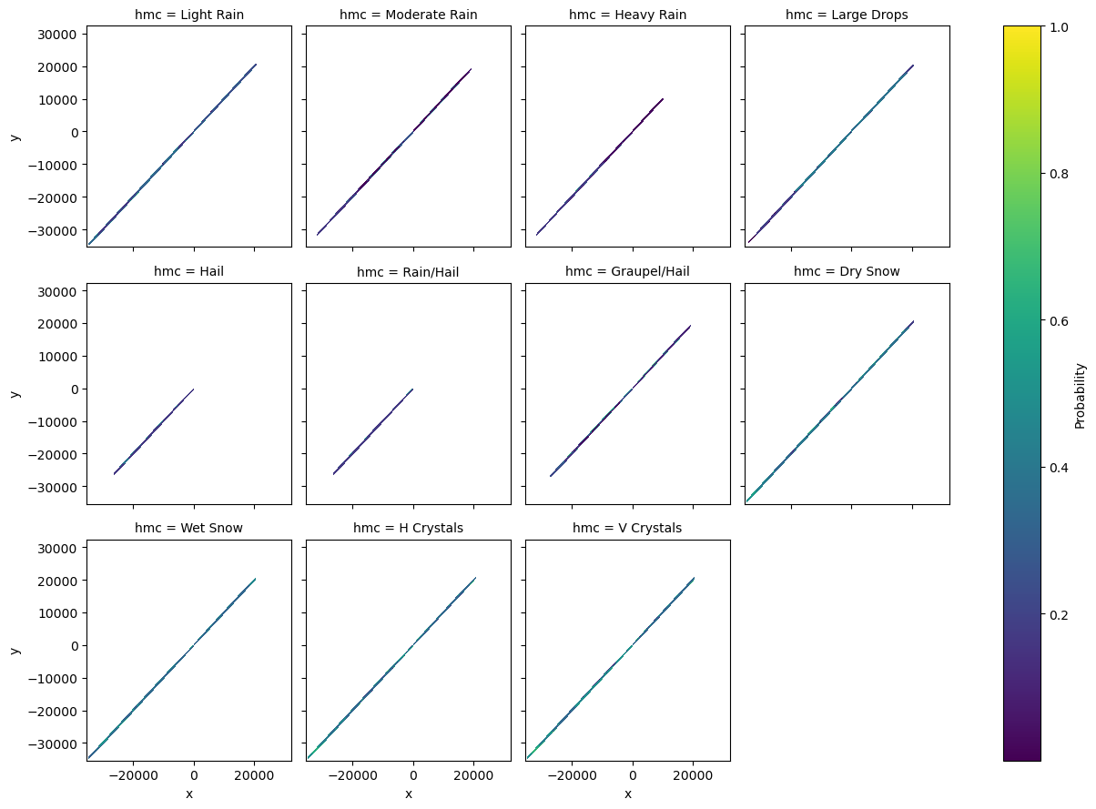
Plot Probability of HMC Types#
[27]:
prob = prob.assign_coords(hmc=np.array(list(pr_types.values())).T[1][:11])
prob = prob.where(prob > 0)
prob.plot(x="x", y="y", col="hmc", col_wrap=4, cbar_kwargs=dict(label="Probability"))
[27]:
<xarray.plot.facetgrid.FacetGrid at 0x7fb3ac5bf590>
Plot maximum probability#
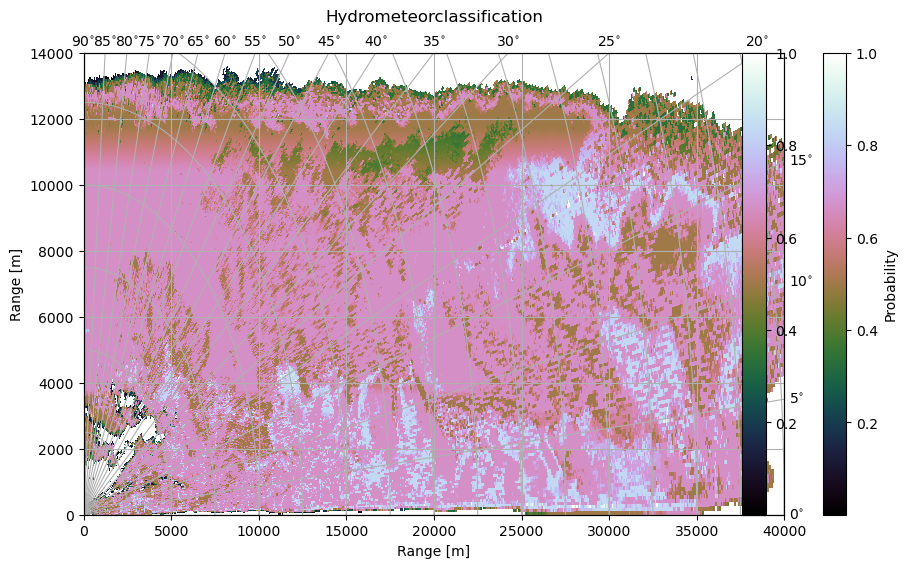
[28]:
fig = plt.figure(figsize=(10, 6))
cmap = "cubehelix"
im = cl_res.max("hmc").wrl.vis.plot(
    ax=111,
    crs={"angular_spacing": 20.0, "radial_spacing": 12.0, "latmin": 2.5},
    cmap=cmap,
    fig=fig,
)
cgax = plt.gca()
cbar = plt.colorbar(im, ax=cgax, fraction=0.046, pad=0.05)
cbar.set_label("Probability")
cgax.set_xlim(0, 40000)
cgax.set_ylim(0, 14000)
t = cgax.set_title("Hydrometeorclassification", y=1.05)

caax = cgax.parasites[0]
caax.set_xlabel("Range [m]")
caax.set_ylabel("Range [m]")
plt.show()
Plot classification result#
[29]:
bounds = np.arange(-0.5, prob.shape[0] + 0.6, 1)
ticks = np.arange(0, prob.shape[0] + 1)
cmap = mpl.cm.get_cmap("cubehelix", len(ticks))
norm = mpl.colors.BoundaryNorm(bounds, cmap.N)
[30]:
hydro = cl_res.argmax("hmc")
hydro.attrs = dict(long_name="Hydrometeorclassification")
hydro = hydro.assign_coords(sweep_mode="rhi")
[31]:
fig = plt.figure(figsize=(10, 8))
im = hydro.wrl.vis.plot(
    ax=111,
    crs={"angular_spacing": 20.0, "radial_spacing": 12.0, "latmin": 2.5},
    norm=norm,
    cmap=cmap,
    fig=fig,
)
cgax = plt.gca()
caax = cgax.parasites[0]
paax = cgax.parasites[1]

cbar = plt.colorbar(im, ticks=ticks, ax=cgax, fraction=0.046, norm=norm, pad=0.05)
cbar.set_label("Hydrometeorclass")
caax.set_xlabel("Range [km]")
caax.set_ylabel("Range [km]")
labels = [pr_types[i][1] for i, _ in enumerate(pr_types)]
labels = cbar.ax.set_yticklabels(labels)
t = cgax.set_title("Hydrometeorclassification", y=1.05)
cgax.set_xlim(0, 40000)
cgax.set_ylim(0, 14000)
plt.tight_layout()
