Grid - WGS84#
Note
The following section is based on the WGS84 ellipsoidal Earth model. Projected X/Y coordinates differ slightly from the original sphere-based grids, while lon/lat coordinates remain largely comparable. We demonstrate how to reproject the sphere-based data onto the WGS84 grid to enable direct comparison. Statistical analyses, including differences and correlations, confirm that the physical precipitation fields are effectively unchanged: differences arise primarily from resampling and interpolation during reprojection, especially near steep gradients or convective cores.
import wradlib as wrl
import matplotlib.pyplot as pl
import numpy as np
import xarray as xr
from osgeo import osr
import cartopy.crs as ccrs
def corners(coords, crs):
    x = coords[0]
    y = coords[1]
    x, y = np.meshgrid(x, y)
    radolan_grid = np.dstack((x, y))
    ll = wrl.georef.reproject(radolan_grid, src_crs=crs, trg_crs=wrl.georef.get_default_projection())
    lon, lat = ll[..., 0], ll[..., 1]
    print(f"SW: {x[0, 0]}, {y[0, 0]} | {lon[0, 0]}, {lat[0, 0]}")
    print(f"SE: {x[0, -1]}, {y[0, 0]} | {lon[0, -1]}, {lat[0, -1]}")
    print(f"NE: {x[0, -1]}, {y[-1, 0]} | {lon[-1, -1]}, {lat[-1, -1]}")
    print(f"NW: {x[0, 0]}, {y[-1, 0]} | {lon[-1, 0]}, {lat[-1, 0]}")
CRS and Corner Points#
Original Sphere with km-scale#
p_legacy = wrl.georef.create_crs("dwd-radolan")
print(p_legacy.to_wkt(pretty=True))

radolan_coords = wrl.georef.get_radolan_coordinates(nrows=900, ncols=900, mode="edge", crs=p_legacy)
corners(radolan_coords, p_legacy)
PROJCRS["Radolan Projection",
    BASEGEOGCRS["Radolan Coordinate System",
        DATUM["Radolan_Kugel",
            ELLIPSOID["Erdkugel",6370040,0,
                LENGTHUNIT["metre",1,
                    ID["EPSG",9001]]]],
        PRIMEM["Greenwich",0,
            ANGLEUNIT["degree",0.0174532925199433],
            ID["EPSG",8901]]],
    CONVERSION["unnamed",
        METHOD["Polar Stereographic (variant B)",
            ID["EPSG",9829]],
        PARAMETER["Latitude of standard parallel",60,
            ANGLEUNIT["degree",0.0174532925199433],
            ID["EPSG",8832]],
        PARAMETER["Longitude of origin",10,
            ANGLEUNIT["degree",0.0174532925199433],
            ID["EPSG",8833]],
        PARAMETER["False easting",0,
            LENGTHUNIT["kilometre",1000],
            ID["EPSG",8806]],
        PARAMETER["False northing",0,
            LENGTHUNIT["kilometre",1000],
            ID["EPSG",8807]]],
    CS[Cartesian,2],
        AXIS["easting",south,
            ORDER[1],
            LENGTHUNIT["kilometre",1000,
                ID["EPSG",9036]]],
        AXIS["northing",south,
            ORDER[2],
            LENGTHUNIT["kilometre",1000,
                ID["EPSG",9036]]]]
SW: -523.4621669218559, -4658.644724265573 | 3.588929950917963, 46.95258041119031
SE: 376.5378330781441, -4658.644724265573 | 14.620921697660032, 47.07046581046634
NE: 376.5378330781441, -3758.644724265573 | 15.720755858619842, 54.74054767018841
NW: -523.4621669218559, -3758.644724265573 | 2.07147965995004, 54.587710521206425
Sphere#
p_legacy_sphere = wrl.georef.create_crs("dwd-radolan-sphere")
print(p_legacy_sphere.to_wkt(pretty=True))

radolan_coords_sphere = wrl.georef.get_radolan_coordinates(nrows=900, ncols=900, mode="edge", crs=p_legacy_sphere)
corners(radolan_coords_sphere, p_legacy_sphere)
PROJCRS["Radolan Projection",
    BASEGEOGCRS["Radolan Coordinate System",
        DATUM["Radolan_Kugel",
            ELLIPSOID["Erdkugel",6370040,0,
                LENGTHUNIT["metre",1,
                    ID["EPSG",9001]]]],
        PRIMEM["Greenwich",0,
            ANGLEUNIT["degree",0.0174532925199433],
            ID["EPSG",8901]]],
    CONVERSION["unnamed",
        METHOD["Polar Stereographic (variant B)",
            ID["EPSG",9829]],
        PARAMETER["Latitude of standard parallel",60,
            ANGLEUNIT["degree",0.0174532925199433],
            ID["EPSG",8832]],
        PARAMETER["Longitude of origin",10,
            ANGLEUNIT["degree",0.0174532925199433],
            ID["EPSG",8833]],
        PARAMETER["False easting",0,
            LENGTHUNIT["metre",1],
            ID["EPSG",8806]],
        PARAMETER["False northing",0,
            LENGTHUNIT["metre",1],
            ID["EPSG",8807]]],
    CS[Cartesian,2],
        AXIS["easting",south,
            ORDER[1],
            LENGTHUNIT["metre",1,
                ID["EPSG",9001]]],
        AXIS["northing",south,
            ORDER[2],
            LENGTHUNIT["metre",1,
                ID["EPSG",9001]]]]
SW: -523462.16692185594, -4658644.724265573 | 3.58892995091796, 46.95258041119032
SE: 376537.83307814406, -4658644.724265573 | 14.620921697660032, 47.070465810466345
NE: 376537.83307814406, -3758644.7242655726 | 15.720755858619842, 54.74054767018842
NW: -523462.16692185594, -3758644.7242655726 | 2.071479659950037, 54.58771052120644
WGS84#
p_legacy_wgs84 = wrl.georef.create_crs("dwd-radolan-wgs84")
print(p_legacy_wgs84.to_wkt(pretty=True))

radolan_coords_wgs84 = wrl.georef.get_radolan_coordinates(nrows=900, ncols=900, mode="edge", crs=p_legacy_wgs84)
corners(radolan_coords_wgs84, p_legacy_wgs84)
PROJCRS["Radolan Projection",
    BASEGEOGCRS["Radolan Coordinate System",
        DATUM["Unknown based on WGS 84 ellipsoid",
            ELLIPSOID["WGS 84",6378137,298.25722356301,
                LENGTHUNIT["metre",1,
                    ID["EPSG",9001]]]],
        PRIMEM["Greenwich",0,
            ANGLEUNIT["degree",0.0174532925199433],
            ID["EPSG",8901]]],
    CONVERSION["unnamed",
        METHOD["Polar Stereographic (variant B)",
            ID["EPSG",9829]],
        PARAMETER["Latitude of standard parallel",60,
            ANGLEUNIT["degree",0.0174532925199433],
            ID["EPSG",8832]],
        PARAMETER["Longitude of origin",10,
            ANGLEUNIT["degree",0.0174532925199433],
            ID["EPSG",8833]],
        PARAMETER["False easting",0,
            LENGTHUNIT["metre",1],
            ID["EPSG",8806]],
        PARAMETER["False northing",0,
            LENGTHUNIT["metre",1],
            ID["EPSG",8807]]],
    CS[Cartesian,2],
        AXIS["easting",south,
            ORDER[1],
            LENGTHUNIT["metre",1,
                ID["EPSG",9001]]],
        AXIS["northing",south,
            ORDER[2],
            LENGTHUNIT["metre",1,
                ID["EPSG",9001]]]]
SW: -523696.8352177028, -4672088.861930594 | 3.6043829965850764, 46.953615333752275
SE: 376303.1647822972, -4672088.861930594 | 14.604822857921036, 47.0715699714179
NE: 376303.1647822972, -3772088.861930594 | 15.69697165758382, 54.738068926343686
NW: -523696.8352177028, -3772088.861930594 | 2.095883211220788, 54.58546705787688
Special CRS with Coordinate System False Origins#
RX#
900x900
p_rx_sphere = wrl.georef.create_crs("dwd-radolan-sphere-rx")
p_rx_wgs84 = wrl.georef.create_crs("dwd-radolan-wgs84-rx")
print(p_rx_sphere.to_wkt(pretty=True))
print(p_rx_wgs84.to_wkt(pretty=True))

radolan_coords_rx_sphere = wrl.georef.get_radolan_coordinates(nrows=900, ncols=900, mode="edge", crs=p_legacy_sphere)
corners(radolan_coords_rx_sphere, p_legacy_sphere)
print()
radolan_coords_rx_wgs84 = wrl.georef.get_radolan_coordinates(nrows=900, ncols=900, mode="edge", crs=p_legacy_wgs84)
corners(radolan_coords_rx_wgs84, p_legacy_wgs84)
PROJCRS["Radolan Projection",
    BASEGEOGCRS["Radolan Coordinate System",
        DATUM["Radolan_Kugel",
            ELLIPSOID["Erdkugel",6370040,0,
                LENGTHUNIT["metre",1,
                    ID["EPSG",9001]]]],
        PRIMEM["Greenwich",0,
            ANGLEUNIT["degree",0.0174532925199433],
            ID["EPSG",8901]]],
    CONVERSION["unnamed",
        METHOD["Polar Stereographic (variant B)",
            ID["EPSG",9829]],
        PARAMETER["Latitude of standard parallel",60,
            ANGLEUNIT["degree",0.0174532925199433],
            ID["EPSG",8832]],
        PARAMETER["Longitude of origin",10,
            ANGLEUNIT["degree",0.0174532925199433],
            ID["EPSG",8833]],
        PARAMETER["False easting",522962.166921856,
            LENGTHUNIT["metre",1],
            ID["EPSG",8806]],
        PARAMETER["False northing",3759144.72426557,
            LENGTHUNIT["metre",1],
            ID["EPSG",8807]]],
    CS[Cartesian,2],
        AXIS["easting",south,
            ORDER[1],
            LENGTHUNIT["metre",1,
                ID["EPSG",9001]]],
        AXIS["northing",south,
            ORDER[2],
            LENGTHUNIT["metre",1,
                ID["EPSG",9001]]]]
PROJCRS["Radolan Projection",
    BASEGEOGCRS["Radolan Coordinate System",
        DATUM["Unknown based on WGS 84 ellipsoid",
            ELLIPSOID["WGS 84",6378137,298.25722356301,
                LENGTHUNIT["metre",1,
                    ID["EPSG",9001]]]],
        PRIMEM["Greenwich",0,
            ANGLEUNIT["degree",0.0174532925199433],
            ID["EPSG",8901]]],
    CONVERSION["unnamed",
        METHOD["Polar Stereographic (variant B)",
            ID["EPSG",9829]],
        PARAMETER["Latitude of standard parallel",60,
            ANGLEUNIT["degree",0.0174532925199433],
            ID["EPSG",8832]],
        PARAMETER["Longitude of origin",10,
            ANGLEUNIT["degree",0.0174532925199433],
            ID["EPSG",8833]],
        PARAMETER["False easting",523196.835217778,
            LENGTHUNIT["metre",1],
            ID["EPSG",8806]],
        PARAMETER["False northing",3772588.86193113,
            LENGTHUNIT["metre",1],
            ID["EPSG",8807]]],
    CS[Cartesian,2],
        AXIS["easting",south,
            ORDER[1],
            LENGTHUNIT["metre",1,
                ID["EPSG",9001]]],
        AXIS["northing",south,
            ORDER[2],
            LENGTHUNIT["metre",1,
                ID["EPSG",9001]]]]
SW: -523462.16692185594, -4658644.724265573 | 3.58892995091796, 46.95258041119032
SE: 376537.83307814406, -4658644.724265573 | 14.620921697660032, 47.070465810466345
NE: 376537.83307814406, -3758644.7242655726 | 15.720755858619842, 54.74054767018842
NW: -523462.16692185594, -3758644.7242655726 | 2.071479659950037, 54.58771052120644
SW: -523696.8352177028, -4672088.861930594 | 3.6043829965850764, 46.953615333752275
SE: 376303.1647822972, -4672088.861930594 | 14.604822857921036, 47.0715699714179
NE: 376303.1647822972, -3772088.861930594 | 15.69697165758382, 54.738068926343686
NW: -523696.8352177028, -3772088.861930594 | 2.095883211220788, 54.58546705787688
DE1200#
1200x1100
Examplarisch lautet der proj-String für das DE1200-Gitter im WGS84-Erdmodell:
+proj=stere +lat_0=90 +lat_ts=60 +lon_0=10 +a=6378137 +b=6356752.3142451802 +no_defs +x_0=543196.83521776402 +y_0=3622588.8619310018
For wradlib radolan xarray backend we keep the projection without any false offsets. The user should be able to directly use the attached coordinates without any projection handling.
p_de1200_sphere = wrl.georef.create_crs("dwd-radolan-sphere-de1200")
p_de1200_wgs84 = wrl.georef.create_crs("dwd-radolan-wgs84-de1200")
print(p_de1200_sphere.to_wkt(pretty=True))
print(p_de1200_wgs84.to_wkt(pretty=True))
p_legacy_sphere = wrl.georef.create_crs("dwd-radolan-sphere")
radolan_coords_de1200_sphere = wrl.georef.get_radolan_coordinates(nrows=1200, ncols=1100, mode="edge", crs=p_legacy_sphere)
corners(radolan_coords_de1200_sphere, p_legacy_sphere)
print()
radolan_coords_de1200_wgs84 = wrl.georef.get_radolan_coordinates(nrows=1200, ncols=1100, mode="edge", crs=p_legacy_wgs84)
corners(radolan_coords_de1200_wgs84, p_legacy_wgs84)
PROJCRS["Radolan Projection",
    BASEGEOGCRS["Radolan Coordinate System",
        DATUM["Radolan_Kugel",
            ELLIPSOID["Erdkugel",6370040,0,
                LENGTHUNIT["metre",1,
                    ID["EPSG",9001]]]],
        PRIMEM["Greenwich",0,
            ANGLEUNIT["degree",0.0174532925199433],
            ID["EPSG",8901]]],
    CONVERSION["unnamed",
        METHOD["Polar Stereographic (variant B)",
            ID["EPSG",9829]],
        PARAMETER["Latitude of standard parallel",60,
            ANGLEUNIT["degree",0.0174532925199433],
            ID["EPSG",8832]],
        PARAMETER["Longitude of origin",10,
            ANGLEUNIT["degree",0.0174532925199433],
            ID["EPSG",8833]],
        PARAMETER["False easting",542962.166921857,
            LENGTHUNIT["metre",1],
            ID["EPSG",8806]],
        PARAMETER["False northing",3609144.72426557,
            LENGTHUNIT["metre",1],
            ID["EPSG",8807]]],
    CS[Cartesian,2],
        AXIS["easting",south,
            ORDER[1],
            LENGTHUNIT["metre",1,
                ID["EPSG",9001]]],
        AXIS["northing",south,
            ORDER[2],
            LENGTHUNIT["metre",1,
                ID["EPSG",9001]]]]
PROJCRS["Radolan Projection",
    BASEGEOGCRS["Radolan Coordinate System",
        DATUM["Unknown based on WGS 84 ellipsoid",
            ELLIPSOID["WGS 84",6378137,298.25722356301,
                LENGTHUNIT["metre",1,
                    ID["EPSG",9001]]]],
        PRIMEM["Greenwich",0,
            ANGLEUNIT["degree",0.0174532925199433],
            ID["EPSG",8901]]],
    CONVERSION["unnamed",
        METHOD["Polar Stereographic (variant B)",
            ID["EPSG",9829]],
        PARAMETER["Latitude of standard parallel",60,
            ANGLEUNIT["degree",0.0174532925199433],
            ID["EPSG",8832]],
        PARAMETER["Longitude of origin",10,
            ANGLEUNIT["degree",0.0174532925199433],
            ID["EPSG",8833]],
        PARAMETER["False easting",543196.835217764,
            LENGTHUNIT["metre",1],
            ID["EPSG",8806]],
        PARAMETER["False northing",3622588.861931,
            LENGTHUNIT["metre",1],
            ID["EPSG",8807]]],
    CS[Cartesian,2],
        AXIS["easting",south,
            ORDER[1],
            LENGTHUNIT["metre",1,
                ID["EPSG",9001]]],
        AXIS["northing",south,
            ORDER[2],
            LENGTHUNIT["metre",1,
                ID["EPSG",9001]]]]
SW: -543462.1669218559, -4808644.724265573 | 3.551921296126042, 45.69587048112079
SE: 556537.8330781441, -4808644.724265573 | 16.601865425773298, 45.683583312355395
NE: 556537.8330781441, -3608644.7242655726 | 18.767281722152354, 55.848486916828215
NW: -543462.1669218559, -3608644.7242655726 | 1.4356121433517017, 55.865842891720284
SW: -543696.8352177028, -4822088.861930594 | 3.5669946350078927, 45.69642537739009
SE: 556303.1647822972, -4822088.861930594 | 16.58086934859828, 45.68460578137084
NE: 556303.1647822972, -3622088.861930594 | 18.731616454667478, 55.84543856325578
NW: -543696.8352177028, -3622088.861930594 | 1.4633015102566664, 55.86208710824985
DE4800#
4800x4400
p_de4800_sphere = wrl.georef.create_crs("dwd-radolan-sphere-de4800")
p_de4800_wgs84 = wrl.georef.create_crs("dwd-radolan-wgs84-de4800")
print(p_de4800_sphere.to_wkt(pretty=True))
print(p_de4800_wgs84.to_wkt(pretty=True))

p_legacy_sphere = wrl.georef.create_crs("dwd-radolan-sphere")
radolan_coords_de4800_sphere = wrl.georef.get_radolan_coordinates(nrows=4800, ncols=4400, mode="edge", crs=p_legacy_sphere)
corners(radolan_coords_de4800_sphere, p_legacy_sphere)
print()
radolan_coords_de4800_wgs84 = wrl.georef.get_radolan_coordinates(nrows=4800, ncols=4400, mode="edge", crs=p_legacy_wgs84)
corners(radolan_coords_de4800_wgs84, p_legacy_wgs84)
PROJCRS["Radolan Projection",
    BASEGEOGCRS["Radolan Coordinate System",
        DATUM["Radolan_Kugel",
            ELLIPSOID["Erdkugel",6370040,0,
                LENGTHUNIT["metre",1,
                    ID["EPSG",9001]]]],
        PRIMEM["Greenwich",0,
            ANGLEUNIT["degree",0.0174532925199433],
            ID["EPSG",8901]]],
    CONVERSION["unnamed",
        METHOD["Polar Stereographic (variant B)",
            ID["EPSG",9829]],
        PARAMETER["Latitude of standard parallel",60,
            ANGLEUNIT["degree",0.0174532925199433],
            ID["EPSG",8832]],
        PARAMETER["Longitude of origin",10,
            ANGLEUNIT["degree",0.0174532925199433],
            ID["EPSG",8833]],
        PARAMETER["False easting",543337.166921856,
            LENGTHUNIT["metre",1],
            ID["EPSG",8806]],
        PARAMETER["False northing",3608769.72426557,
            LENGTHUNIT["metre",1],
            ID["EPSG",8807]]],
    CS[Cartesian,2],
        AXIS["easting",south,
            ORDER[1],
            LENGTHUNIT["metre",1,
                ID["EPSG",9001]]],
        AXIS["northing",south,
            ORDER[2],
            LENGTHUNIT["metre",1,
                ID["EPSG",9001]]]]
PROJCRS["Radolan Projection",
    BASEGEOGCRS["Radolan Coordinate System",
        DATUM["Unknown based on WGS 84 ellipsoid",
            ELLIPSOID["WGS 84",6378137,298.25722356301,
                LENGTHUNIT["metre",1,
                    ID["EPSG",9001]]]],
        PRIMEM["Greenwich",0,
            ANGLEUNIT["degree",0.0174532925199433],
            ID["EPSG",8901]]],
    CONVERSION["unnamed",
        METHOD["Polar Stereographic (variant B)",
            ID["EPSG",9829]],
        PARAMETER["Latitude of standard parallel",60,
            ANGLEUNIT["degree",0.0174532925199433],
            ID["EPSG",8832]],
        PARAMETER["Longitude of origin",10,
            ANGLEUNIT["degree",0.0174532925199433],
            ID["EPSG",8833]],
        PARAMETER["False easting",543571.835217764,
            LENGTHUNIT["metre",1],
            ID["EPSG",8806]],
        PARAMETER["False northing",3622213.861931,
            LENGTHUNIT["metre",1],
            ID["EPSG",8807]]],
    CS[Cartesian,2],
        AXIS["easting",south,
            ORDER[1],
            LENGTHUNIT["metre",1,
                ID["EPSG",9001]]],
        AXIS["northing",south,
            ORDER[2],
            LENGTHUNIT["metre",1,
                ID["EPSG",9001]]]]
SW: -543462.1669218559, -4808644.724265573 | 3.551921296126042, 45.69587048112079
SE: 556537.8330781441, -4808644.724265573 | 16.601865425773298, 45.683583312355395
NE: 556537.8330781441, -3608644.7242655726 | 18.767281722152354, 55.848486916828215
NW: -543462.1669218559, -3608644.7242655726 | 1.4356121433517017, 55.865842891720284
SW: -543696.8352177028, -4822088.861930594 | 3.5669946350078927, 45.69642537739009
SE: 556303.1647822972, -4822088.861930594 | 16.58086934859828, 45.68460578137084
NE: 556303.1647822972, -3622088.861930594 | 18.731616454667478, 55.84543856325578
NW: -543696.8352177028, -3622088.861930594 | 1.4633015102566664, 55.86208710824985
POLARA - Grids#
The POLARA team circulated an internal document Komposits aus Polara-Produktion which contains information on projection and grids. In the following section this information is used.
def grid_corner(xy, ll):
    x = xy[..., 0]
    y = xy[..., 1]
    lon = ll[..., 0]
    lat = ll[..., 1]
    print(f"SW: {x[0, 0]}, {y[0, 0]} | {lon[0, 0]}, {lat[0, 0]}")
    print(f"SE: {x[0, -1]}, {y[0, -1]} | {lon[0, -1]}, {lat[0, -1]}")
    print(f"NE: {x[-1, -1]}, {y[-1, -1]} | {lon[-1, -1]}, {lat[-1, -1]}")
    print(f"NW: {x[-1, 0]}, {y[-1, 0]} | {lon[-1, 0]}, {lat[-1, 0]}")
RX 900x900#
radolan_grid_rx_sphere_xy = wrl.georef.get_radolan_grid(nrows=900, ncols=900, wgs84=False, mode="edge", crs=p_legacy_sphere)
radolan_grid_rx_sphere_ll = wrl.georef.get_radolan_grid(nrows=900, ncols=900, wgs84=True, mode="edge", crs=p_legacy_sphere)
grid_corner(radolan_grid_rx_sphere_xy, radolan_grid_rx_sphere_ll)
radolan_grid_rx_wgs84_xy = wrl.georef.get_radolan_grid(nrows=900, ncols=900, wgs84=False, mode="edge", crs=p_legacy_wgs84)
radolan_grid_rx_wgs84_ll = wrl.georef.get_radolan_grid(nrows=900, ncols=900, wgs84=True, mode="edge", crs=p_legacy_wgs84)
print()
grid_corner(radolan_grid_rx_wgs84_xy, radolan_grid_rx_wgs84_ll)
SW: -523462.16692185594, -4658644.724265573 | 3.58892995091796, 46.95258041119032
SE: 376537.83307814406, -4658644.724265573 | 14.620921697660032, 47.070465810466345
NE: 376537.83307814406, -3758644.7242655726 | 15.720755858619842, 54.74054767018842
NW: -523462.16692185594, -3758644.7242655726 | 2.071479659950037, 54.58771052120644
SW: -523696.8352177028, -4672088.861930594 | 3.6043829965850764, 46.953615333752275
SE: 376303.1647822972, -4672088.861930594 | 14.604822857921036, 47.0715699714179
NE: 376303.1647822972, -3772088.861930594 | 15.69697165758382, 54.738068926343686
NW: -523696.8352177028, -3772088.861930594 | 2.095883211220788, 54.58546705787688
DE1200 1200x1100#
radolan_grid_de1200_sphere_xy = wrl.georef.get_radolan_grid(nrows=1200, ncols=1100, wgs84=False, mode="edge", crs=p_legacy_sphere)
radolan_grid_de1200_sphere_ll = wrl.georef.get_radolan_grid(nrows=1200, ncols=1100, wgs84=True, mode="edge", crs=p_legacy_sphere)
grid_corner(radolan_grid_de1200_sphere_xy, radolan_grid_de1200_sphere_ll)
radolan_grid_de1200_wgs84_xy = wrl.georef.get_radolan_grid(nrows=1200, ncols=1100, wgs84=False, mode="edge", crs=p_legacy_wgs84)
radolan_grid_de1200_wgs84_ll = wrl.georef.get_radolan_grid(nrows=1200, ncols=1100, wgs84=True, mode="edge", crs=p_legacy_wgs84)
print()
grid_corner(radolan_grid_de1200_wgs84_xy, radolan_grid_de1200_wgs84_ll)
SW: -543462.1669218559, -4808644.724265573 | 3.551921296126042, 45.69587048112079
SE: 556537.8330781441, -4808644.724265573 | 16.601865425773298, 45.683583312355395
NE: 556537.8330781441, -3608644.7242655726 | 18.767281722152354, 55.848486916828215
NW: -543462.1669218559, -3608644.7242655726 | 1.4356121433517017, 55.865842891720284
SW: -543696.8352177028, -4822088.861930594 | 3.5669946350078927, 45.69642537739009
SE: 556303.1647822972, -4822088.861930594 | 16.58086934859828, 45.68460578137084
NE: 556303.1647822972, -3622088.861930594 | 18.731616454667478, 55.84543856325578
NW: -543696.8352177028, -3622088.861930594 | 1.4633015102566664, 55.86208710824985
DE4800 4800x4400#
radolan_grid_de4800_sphere_xy = wrl.georef.get_radolan_grid(nrows=4800, ncols=4400, wgs84=False, mode="edge", crs=p_legacy_sphere)
radolan_grid_de4800_sphere_ll = wrl.georef.get_radolan_grid(nrows=4800, ncols=4400, wgs84=True, mode="edge", crs=p_legacy_sphere)
grid_corner(radolan_grid_de4800_sphere_xy, radolan_grid_de1200_sphere_ll)
radolan_grid_de4800_wgs84_xy = wrl.georef.get_radolan_grid(nrows=4800, ncols=4400, wgs84=False, mode="edge", crs=p_legacy_wgs84)
radolan_grid_de4800_wgs84_ll = wrl.georef.get_radolan_grid(nrows=4800, ncols=4400, wgs84=True, mode="edge", crs=p_legacy_wgs84)
print()
grid_corner(radolan_grid_de4800_wgs84_xy, radolan_grid_de4800_wgs84_ll)
SW: -543462.1669218559, -4808644.724265573 | 3.551921296126042, 45.69587048112079
SE: 556537.8330781441, -4808644.724265573 | 16.601865425773298, 45.683583312355395
NE: 556537.8330781441, -3608644.7242655726 | 18.767281722152354, 55.848486916828215
NW: -543462.1669218559, -3608644.7242655726 | 1.4356121433517017, 55.865842891720284
SW: -543696.8352177028, -4822088.861930594 | 3.5669946350078927, 45.69642537739009
SE: 556303.1647822972, -4822088.861930594 | 16.58086934859828, 45.68460578137084
NE: 556303.1647822972, -3622088.861930594 | 18.731616454667478, 55.84543856325578
NW: -543696.8352177028, -3622088.861930594 | 1.4633015102566664, 55.86208710824985
Example WN DE1200#
In the transition period from sphere model to wgs84 ellipsoid model DWD released both versions. In the following example WN product data is used to showcase this.
SPHERE_FILE = "../data/grid/sphere/WN2204091200_000.gz"
WGS84_FILE = "../data/grid/wgs84/WN2204091200_000.gz"
ds_sphere = xr.open_dataset(SPHERE_FILE, engine="radolan").set_coords("crs")
ds_wgs84 = xr.open_dataset(WGS84_FILE, engine="radolan").set_coords("crs")
/home/docs/checkouts/readthedocs.org/user_builds/radolan-guide/conda/latest/lib/python3.13/site-packages/wradlib/io/radolan.py:1298: UserWarning: no explicit representation of timezones available for np.datetime64
  pred_time = np.array(
/home/docs/checkouts/readthedocs.org/user_builds/radolan-guide/conda/latest/lib/python3.13/site-packages/xarray/conventions.py:204: SerializationWarning: variable 'WN' has multiple fill values {np.int32(2490), np.int32(2500), np.int32(65535)} defined, decoding all values to NaN.
  var = coder.decode(var, name=name)
Assign Coordinates#
We take grid centerpoints as well as edge points.
radolan_grid_de1200_sphere_xy_cp = wrl.georef.get_radolan_grid(nrows=1200, ncols=1100, wgs84=False, mode="center", crs=p_legacy_sphere)
radolan_grid_de1200_sphere_ll_cp = wrl.georef.get_radolan_grid(nrows=1200, ncols=1100, wgs84=True, mode="center", crs=p_legacy_sphere)
radolan_grid_de1200_sphere_xy_sw = wrl.georef.get_radolan_grid(nrows=1200, ncols=1100, wgs84=False, mode="edge", crs=p_legacy_sphere)
radolan_grid_de1200_sphere_ll_sw = wrl.georef.get_radolan_grid(nrows=1200, ncols=1100, wgs84=True, mode="edge", crs=p_legacy_sphere)

radolan_grid_de1200_wgs84_xy_cp = wrl.georef.get_radolan_grid(nrows=1200, ncols=1100, wgs84=False, mode="center", crs=p_legacy_wgs84)
radolan_grid_de1200_wgs84_ll_cp = wrl.georef.get_radolan_grid(nrows=1200, ncols=1100, wgs84=True, mode="center", crs=p_legacy_wgs84)
radolan_grid_de1200_wgs84_xy_sw = wrl.georef.get_radolan_grid(nrows=1200, ncols=1100, wgs84=False, mode="edge", crs=p_legacy_wgs84)
radolan_grid_de1200_wgs84_ll_sw = wrl.georef.get_radolan_grid(nrows=1200, ncols=1100, wgs84=True, mode="edge", crs=p_legacy_wgs84)
ds_sphere = ds_sphere.assign_coords(
    {
        "x_cp": (["y", "x"], radolan_grid_de1200_sphere_xy_cp[..., 0]),
        "y_cp": (["y", "x"], radolan_grid_de1200_sphere_xy_cp[..., 1]),
        "x_sw": (["y1", "x1"], radolan_grid_de1200_sphere_xy_sw[..., 0]),
        "y_sw": (["y1", "x1"], radolan_grid_de1200_sphere_xy_sw[..., 1]),
        "lon_cp": (["y", "x"], radolan_grid_de1200_sphere_ll_cp[..., 0]),
        "lat_cp": (["y", "x"], radolan_grid_de1200_sphere_ll_cp[..., 1]),
        "lon_sw": (["y1", "x1"], radolan_grid_de1200_sphere_ll_sw[..., 0]),
        "lat_sw": (["y1", "x1"], radolan_grid_de1200_sphere_ll_sw[..., 1]),

    }

)
ds_wgs84 = ds_wgs84.assign_coords(
    {
        "x_cp": (["y", "x"], radolan_grid_de1200_wgs84_xy_cp[..., 0]),
        "y_cp": (["y", "x"], radolan_grid_de1200_wgs84_xy_cp[..., 1]),
        "x_sw": (["y1", "x1"], radolan_grid_de1200_wgs84_xy_sw[..., 0]),
        "y_sw": (["y1", "x1"], radolan_grid_de1200_wgs84_xy_sw[..., 1]),
        "lon_cp": (["y", "x"], radolan_grid_de1200_wgs84_ll_cp[..., 0]),
        "lat_cp": (["y", "x"], radolan_grid_de1200_wgs84_ll_cp[..., 1]),
        "lon_sw": (["y1", "x1"], radolan_grid_de1200_wgs84_ll_sw[..., 0]),
        "lat_sw": (["y1", "x1"], radolan_grid_de1200_wgs84_ll_sw[..., 1]),

    }
)
Visualize Selection#
off = 4
sel_sphere = ds_sphere.isel(
    x=slice(470 - off, 470 + off),
    y=slice(600 - off, 600 + off),
    x1=slice(470 - off, 470 + off + 1),
    y1=slice(600 - off, 600 + off + 1),
)
sel_wgs84 = ds_wgs84.isel(
    x=slice(470 - off, 470 + off),
    y=slice(600 - off, 600 + off),
    x1=slice(470 - off, 470 + off + 1),
    y1=slice(600 - off, 600 + off + 1),
)
Visualize Grid Corners#
def plot_grid(ds, coords, corner, ax, **kwargs):
    if coords == "longlat":
        x1 = "lon_sw"
        y1 = "lat_sw"
        x2 = "lon_cp"
        y2 = "lat_cp"
    else:
        x1 = "x_sw"
        y1 = "y_sw"
        x2 = "x_cp"
        y2 = "y_cp"

    if corner == "SW":
        dsp1 = ds.isel(x1=slice(0, 10), y1=slice(0, 10))
        dsp2 = ds.isel(x=slice(0, 9), y=slice(0, 9))
        dsp = ds.isel(x1=slice(0, 1), y1=slice(0, 1))
    elif corner == "SE":
        dsp1 = ds.isel(x1=slice(-10, None), y1=slice(0, 10))
        dsp2 = ds.isel(x=slice(-9, None), y=slice(0, 9))
        dsp = ds.isel(x1=slice(-1, None), y1=slice(0, 1))
    elif corner == "NE":
        dsp1 = ds.isel(x1=slice(-10, None), y1=slice(-10, None))
        dsp2 = ds.isel(x=slice(-9, None), y=slice(-9, None))
        dsp = ds.isel(x1=slice(-1, None), y1=slice(-1, None))
    elif corner == "NW":
        dsp1 = ds.isel(x1=slice(0, 10), y1=slice(-10, None))
        dsp2 = ds.isel(x=slice(0, 9), y=slice(-9, None))
        dsp = ds.isel(x1=slice(0, 1), y1=slice(-1, None))
    else:
        corner = "CN"
        dsp1 = ds.isel(x1=slice(466, 475), y1=slice(596, 605))
        dsp2 = ds.isel(x=slice(466, 474), y=slice(596, 604))
        dsp = ds.isel(x1=slice(470, 471), y1=slice(600, 601))

    dsp1.plot.scatter(x=x1, y=y1, marker="x", ax=ax, **kwargs)
    dsp2.plot.scatter(x=x2, y=y2, marker=".", ax=ax, **kwargs)
    dsp.plot.scatter(x=x1, y=y1, marker="X", s=120, ax=ax,
                     label=f"{dsp[x1].values.item():.10g}, {dsp[y1].values.item():.10g}",
                     **kwargs)

    lon = dsp1[x1].values
    lat = dsp1[y1].values
    ax.plot(lon, lat, **kwargs)
    ax.plot(lon.T, lat.T, **kwargs)
    ax.grid(
        True,
        which="both",
        linestyle="--",
        linewidth=0.5,
        alpha=0.7
    )

    ax.set_title(f"{corner}")
    ax.legend()
fig, ((ax0, ax1), (ax2, ax3)) = pl.subplots(2, 2, figsize=(16, 16))

plot_grid(ds_sphere, "longlat", "NW", ax0, color="lightblue")
plot_grid(ds_wgs84, "longlat", "NW", ax0, color="orange")

plot_grid(ds_sphere, "longlat", "NE", ax1, color="lightblue")
plot_grid(ds_wgs84, "longlat", "NE", ax1, color="orange")

plot_grid(ds_sphere, "longlat", "SW", ax2, color="lightblue")
plot_grid(ds_wgs84, "longlat", "SW", ax2, color="orange")

plot_grid(ds_sphere, "longlat", "SE", ax3, color="lightblue")
plot_grid(ds_wgs84, "longlat", "SE", ax3, color="orange")

fig.tight_layout()
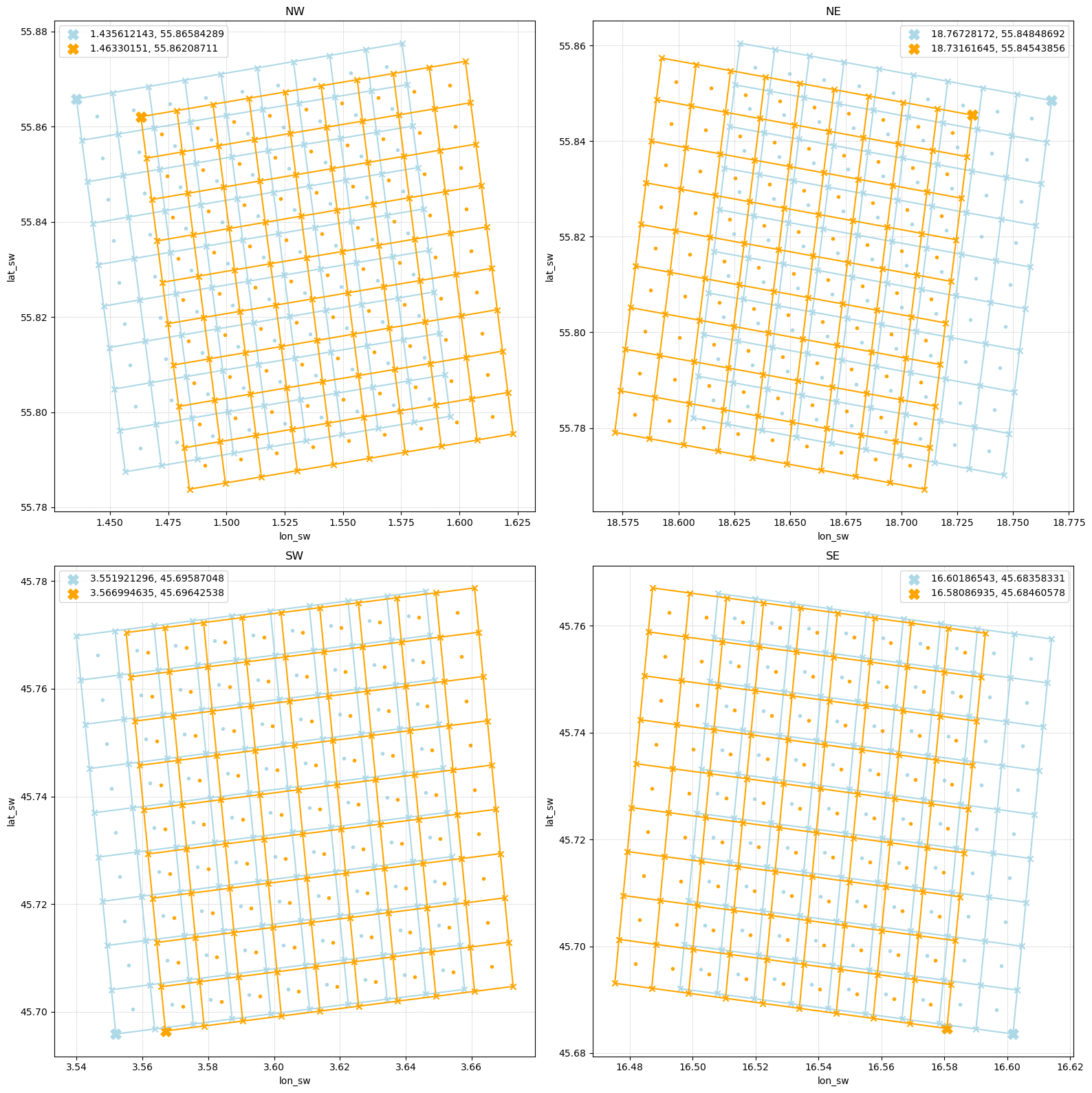
Data: RADOLAN — Deutscher Wetterdienst (DWD). Licensed under CC BY 4.0.
Visualize Grid Center#
fig = pl.figure(figsize=(8, 8))
ax = fig.add_subplot(111)
plot_grid(ds_sphere, "longlat", "CN", ax, color="lightblue")
plot_grid(ds_wgs84, "longlat", "CN", ax, color="orange")
fig.tight_layout()
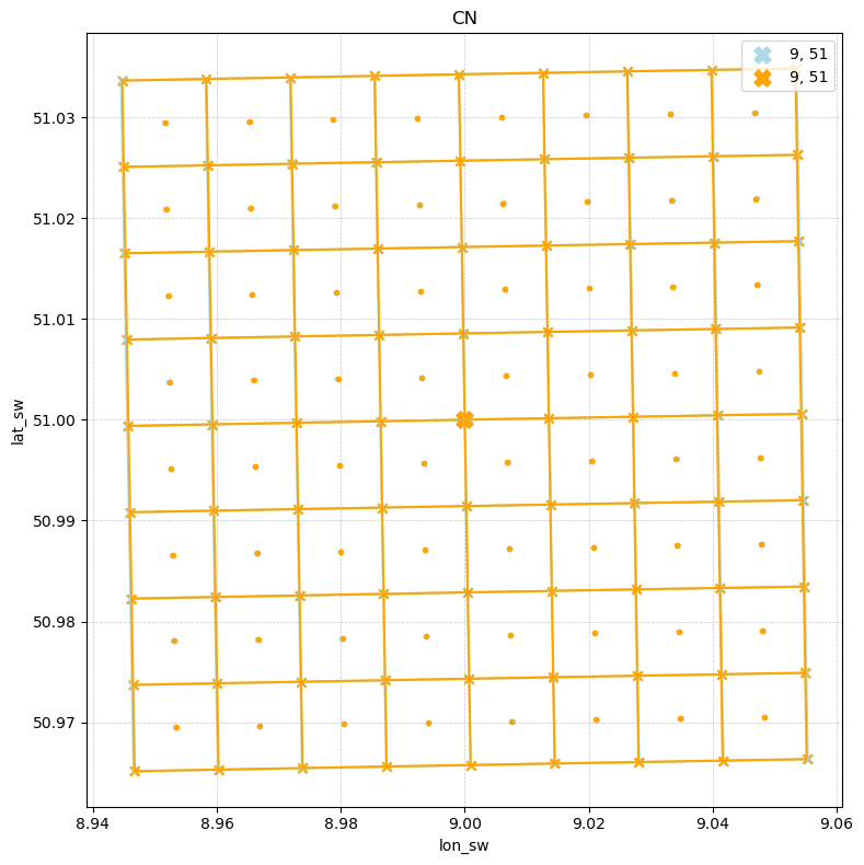
Data: RADOLAN — Deutscher Wetterdienst (DWD). Licensed under CC BY 4.0.
Visualize Map projection#
map_proj_wgs84 = ccrs.Stereographic(true_scale_latitude=60., central_latitude=90., central_longitude=10.,
                                    false_easting=0., false_northing=0.)

sphere = ccrs.Globe(ellipse="sphere", semimajor_axis="6370040", semiminor_axis="6370040")
map_proj_sphere = ccrs.Stereographic(true_scale_latitude=60., central_latitude=90., central_longitude=10.,
                                     globe=sphere,
                                     false_easting=0, false_northing=0)
cbar_kwargs={
        "pad": 0.1,
    }
1D XY Coordinates#
fig, (ax0, ax1) = pl.subplots(2, 1, figsize=(10, 10), subplot_kw=dict(projection=ccrs.PlateCarree()))

sel_sphere.WN.plot(x="x", y="y", ax=ax0, transform=map_proj_sphere, cmap="viridis", cbar_kwargs=cbar_kwargs)
ax0.scatter(sel_sphere.x, sel_sphere.y, c="r", marker="o", transform=map_proj_sphere, label="sphere - cp")
ax0.gridlines(draw_labels=True)

sel_wgs84.WN.plot(x="x", y="y", ax=ax1, transform=map_proj_wgs84, cmap="viridis", cbar_kwargs=cbar_kwargs)
ax1.scatter(sel_wgs84.x, sel_wgs84.y, c="b", marker="x", transform=map_proj_wgs84, label="wgs84")
ax1.gridlines(draw_labels=True)

fig.tight_layout()
Data: RADOLAN — Deutscher Wetterdienst (DWD). Licensed under CC BY 4.0.
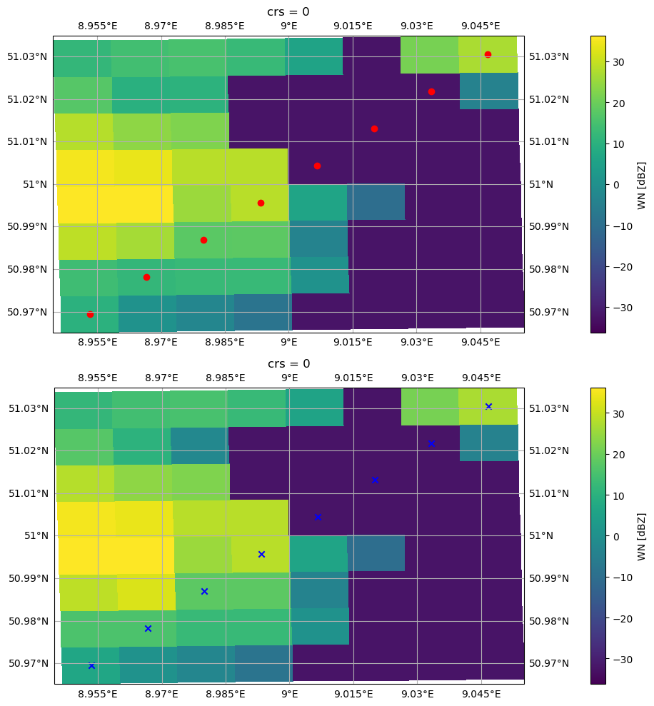
2D Longlat Coordinates#
fig, (ax0, ax1) = pl.subplots(2, 1, figsize=(10, 10), subplot_kw=dict(projection=ccrs.PlateCarree()))

# plot for wgs84 grid
sel_sphere.WN.plot(x="lon_cp", y="lat_cp", ax=ax0, infer_intervals=True, cmap="viridis", cbar_kwargs=cbar_kwargs)
ax0.scatter(sel_sphere.lon_cp, sel_sphere.lat_cp, c="r", marker="o", label="sphere - cp")
ax0.scatter(sel_sphere.lon_sw, sel_wgs84.lat_sw, c="b", marker="x", label="sphere - sw")
ax0.set_title(f"Sphere")
ax0.gridlines(draw_labels=True)
ax0.legend()

# plot for sphere grid
sel_wgs84.WN.plot(x="lon_cp", y="lat_cp", ax=ax1, infer_intervals=True, cmap="viridis", cbar_kwargs=cbar_kwargs)
ax1.scatter(sel_wgs84.lon_cp, sel_wgs84.lat_cp, c="y", marker="o", label="wgs84 - cp")
ax1.scatter(sel_wgs84.lon_sw, sel_wgs84.lat_sw, c="c", marker="x", label="wgs84 - sw")
ax1.set_title(f"WGS84")
ax1.gridlines(draw_labels=True)
ax1.legend()

fig.suptitle("Plotting via longlat coordinates")
fig.tight_layout()

Data: RADOLAN — Deutscher Wetterdienst (DWD). Licensed under CC BY 4.0.
2D XY Coordinates#
fig, (ax0, ax1) = pl.subplots(2, 1, figsize=(10, 10), subplot_kw=dict(projection=ccrs.PlateCarree()))

# plot for wgs84 grid
sel_sphere.WN.plot(x="x_cp", y="y_cp", ax=ax0, transform=map_proj_sphere, infer_intervals=True, cmap="viridis", cbar_kwargs=cbar_kwargs)
ax0.scatter(sel_sphere.x_cp, sel_sphere.y_cp, c="r", marker="o", transform=map_proj_sphere, label="sphere - cp")
ax0.scatter(sel_sphere.x_sw, sel_sphere.y_sw, c="b", marker="x", transform=map_proj_sphere, label="sphere - sw")
ax0.set_title(f"Sphere")
ax0.gridlines(draw_labels=True)
ax0.legend()

# plot for sphere grid
sel_wgs84.WN.plot(x="x_cp", y="y_cp", ax=ax1,  transform=map_proj_wgs84, infer_intervals=True, cmap="viridis", cbar_kwargs=cbar_kwargs)
ax1.scatter(sel_wgs84.x_cp, sel_wgs84.y_cp, c="y", marker="o",  transform=map_proj_wgs84, label="wgs84 - cp")
ax1.scatter(sel_wgs84.x_sw, sel_wgs84.y_sw, c="c", marker="x",  transform=map_proj_wgs84, label="wgs84 - sw")
ax1.set_title(f"WGS84")
ax1.gridlines(draw_labels=True)
ax1.legend()

fig.suptitle("Plotting via xy coordinates")
fig.tight_layout()
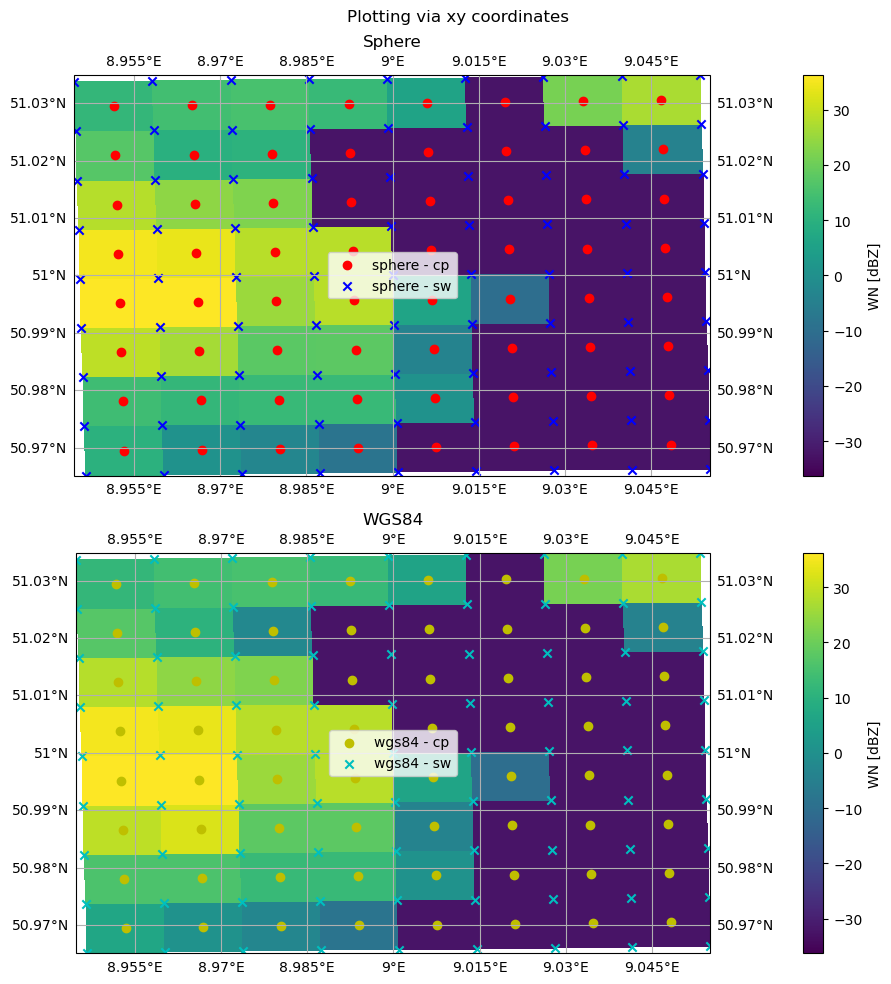
Data: RADOLAN — Deutscher Wetterdienst (DWD). Licensed under CC BY 4.0.
Project back and forth#
using rioxarray
Fix NaN and CRS#
import rioxarray
import numpy as np

ds_sphere_x = ds_sphere.rio.write_crs(p_legacy_sphere, "spatial_ref")

da = ds_sphere_x["WN"]
da.attrs.pop("_FillValue", None)
da.encoding.pop("_FillValue", None)
da = da.rio.write_nodata(-9999)
ds_sphere_x["WN"] = da

ds_wgs84_x  = ds_wgs84.rio.write_crs(p_legacy_wgs84, "spatial_ref")

da = ds_wgs84_x["WN"]
da.attrs.pop("_FillValue", None)
da.encoding.pop("_FillValue", None)
da = da.rio.write_nodata(-9999)
ds_wgs84_x["WN"] = da
Reproject#
sphere_on_wgs = ds_sphere_x["WN"].rio.reproject_match(
    ds_wgs84_x["WN"],
    resampling="bilinear"
)
ds_wgs84_x = ds_wgs84_x.assign(WNX=sphere_on_wgs)

wgs_on_sphere = ds_wgs84_x["WN"].rio.reproject_match(
    ds_sphere_x["WN"],
    resampling="bilinear"
)
ds_sphere_x = ds_sphere_x.assign(WNX=wgs_on_sphere)
Calculate Differences#
diff_wgs84 = ds_wgs84_x["WN"] - ds_wgs84_x["WNX"]
ds_wgs84_x = ds_wgs84_x.assign(DIFF=diff_wgs84)
abs_diff_wgs84 = np.abs(diff_wgs84)
ds_wgs84_x = ds_wgs84_x.assign(ABSDIFF=abs_diff_wgs84)
print("Mean difference:", float(diff_wgs84.mean()))
print("Mean absolute difference:", float(abs_diff_wgs84.mean()))
print("Max absolute difference:", float(abs_diff_wgs84.max()))
print("Std difference:", float(diff_wgs84.std()))
Mean difference: -0.05800255388021469
Mean absolute difference: 1.2759711742401123
Max absolute difference: 67.06459045410156
Std difference: 4.465682029724121
diff_sphere = ds_sphere_x["WN"] - ds_sphere_x["WNX"]
ds_sphere_x = ds_sphere_x.assign(DIFF=diff_sphere)
abs_diff_sphere = np.abs(diff_sphere)
ds_sphere_x = ds_sphere_x.assign(ABSDIFF=abs_diff_sphere)
print("Mean difference:", float(diff_sphere.mean()))
print("Mean absolute difference:", float(abs_diff_sphere.mean()))
print("Max absolute difference:", float(abs_diff_sphere.max()))
print("Std difference:", float(diff_sphere.std()))
Mean difference: 0.057889312505722046
Mean absolute difference: 1.2728506326675415
Max absolute difference: 84.4000015258789
Std difference: 4.4578704833984375
Visualize at Grid Center#
fig, ((ax0, ax1), (ax2, ax3), (ax4, ax5), (ax6, ax7) ) = pl.subplots(4, 2, figsize=(16, 24), sharex=True, sharey=True)

ds_sphere_x["WN"].isel(x=slice(466, 474), y=slice(596, 604)).plot(x="lon_cp", y="lat_cp", ax=ax0, vmin=-32, vmax=40, cmap="viridis")
ax0.set_title("Sphere WN")
ds_wgs84_x["WN"].isel(x=slice(466, 474), y=slice(596, 604)).plot(x="lon_cp", y="lat_cp", ax=ax1, vmin=-32, vmax=40, cmap="viridis")
ax1.set_title("WGS84 WN")
ds_sphere_x["WNX"].isel(x=slice(466, 474), y=slice(596, 604)).plot(x="lon_cp", y="lat_cp", ax=ax2, vmin=-32, vmax=40, cmap="viridis")
ax2.set_title("WGS84 WN reprojected to Sphere")
ds_wgs84_x["WNX"].isel(x=slice(466, 474), y=slice(596, 604)).plot(x="lon_cp", y="lat_cp", ax=ax3, vmin=-32, vmax=40, cmap="viridis")
ax3.set_title("Sphere WN reprojected to WGS84")
ds_sphere_x["DIFF"].isel(x=slice(466, 474), y=slice(596, 604)).plot(x="lon_cp", y="lat_cp", ax=ax4, vmin=-15, vmax=15, cmap="seismic")
ax4.set_title("DIFF of the above")
ds_wgs84_x["DIFF"].isel(x=slice(466, 474), y=slice(596, 604)).plot(x="lon_cp", y="lat_cp", ax=ax5, vmin=-15, vmax=15, cmap="seismic")
ax5.set_title("DIFF of the above")
ds_sphere_x["ABSDIFF"].isel(x=slice(466, 474), y=slice(596, 604)).plot(x="lon_cp", y="lat_cp", ax=ax6, vmin=0, vmax=15, cmap="viridis")
ax6.set_title("ABSDIFF of the above")
ds_wgs84_x["ABSDIFF"].isel(x=slice(466, 474), y=slice(596, 604)).plot(x="lon_cp", y="lat_cp", ax=ax7, vmin=0, vmax=15, cmap="viridis")
ax7.set_title("ABSDIFF of the above")

fig.tight_layout()
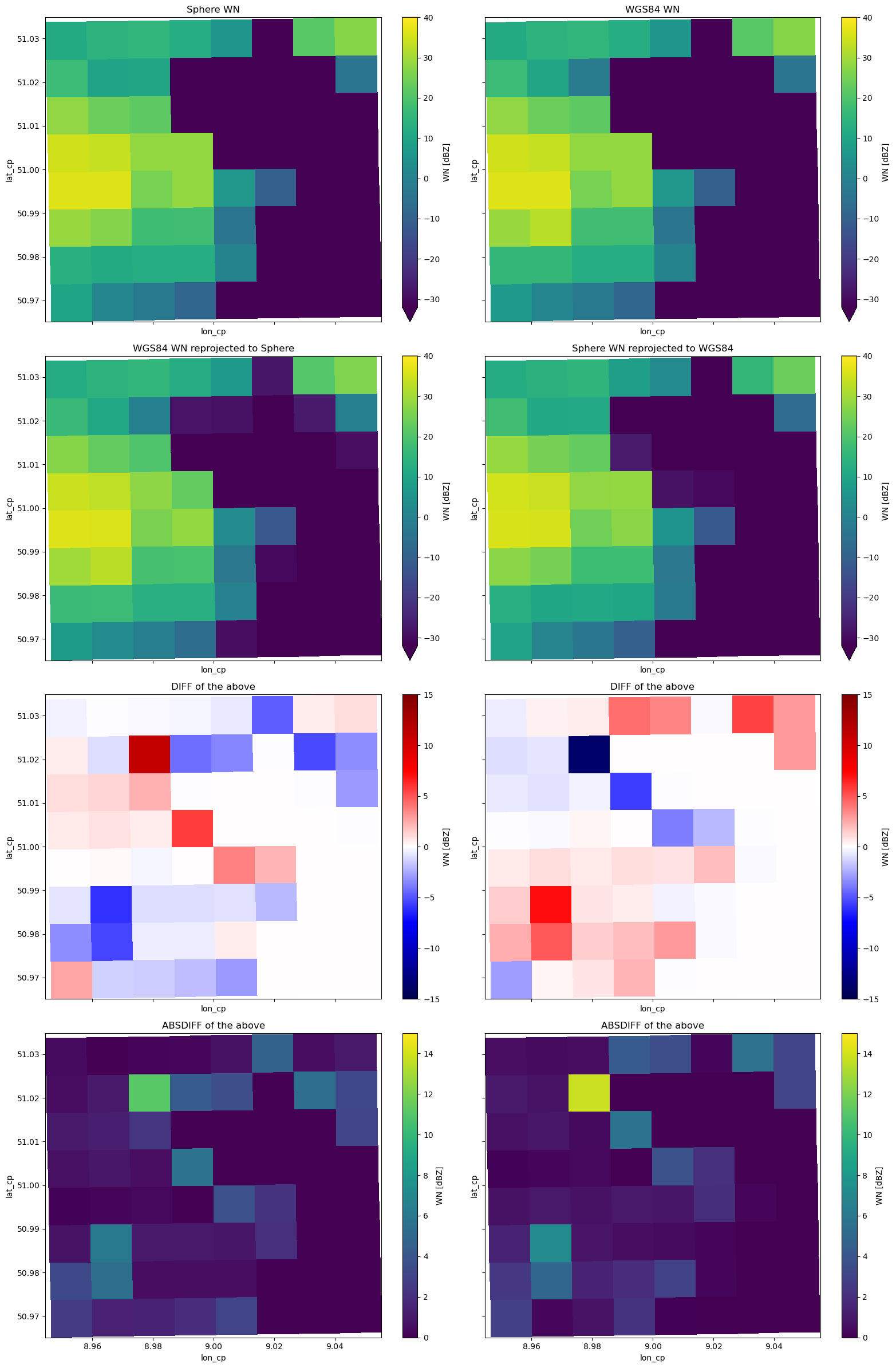
Data: RADOLAN — Deutscher Wetterdienst (DWD). Licensed under CC BY 4.0.
Visualize Complete Grid#
fig, ((ax0, ax1), (ax2, ax3), (ax4, ax5), (ax6, ax7)) = pl.subplots(4, 2, figsize=(16, 24), sharex=True, sharey=True)

ds_sphere_x["WN"].plot(x="lon_cp", y="lat_cp", ax=ax0, vmin=-32, vmax=50)
ax0.set_title("Sphere WN")
ds_wgs84_x["WN"].plot(x="lon_cp", y="lat_cp", ax=ax1, vmin=-32, vmax=50)
ax1.set_title("WGS84 WN")
ds_sphere_x["WNX"].plot(x="lon_cp", y="lat_cp", ax=ax2, vmin=-32, vmax=50)
ax2.set_title("WGS84 WN reprojected to Sphere")
ds_wgs84_x["WNX"].plot(x="lon_cp", y="lat_cp", ax=ax3, vmin=-32, vmax=50)
ax3.set_title("Sphere WN reprojected to WGS84")
ds_sphere_x["DIFF"].plot(x="lon_cp", y="lat_cp", ax=ax4, vmin=-15, vmax=15, cmap="seismic")
ax4.set_title("DIFF of the above")
ds_wgs84_x["DIFF"].plot(x="lon_cp", y="lat_cp", ax=ax5, vmin=-15, vmax=15, cmap="seismic")
ax5.set_title("DIFF of the above")
ds_sphere_x["ABSDIFF"].plot(x="lon_cp", y="lat_cp", ax=ax6, vmin=0, vmax=15, cmap="viridis")
ax6.set_title("ABSDIFF of the above")
ds_wgs84_x["ABSDIFF"].plot(x="lon_cp", y="lat_cp", ax=ax7, vmin=0, vmax=15, cmap="viridis")
ax7.set_title("ABSDIFF of the above")

fig.tight_layout()
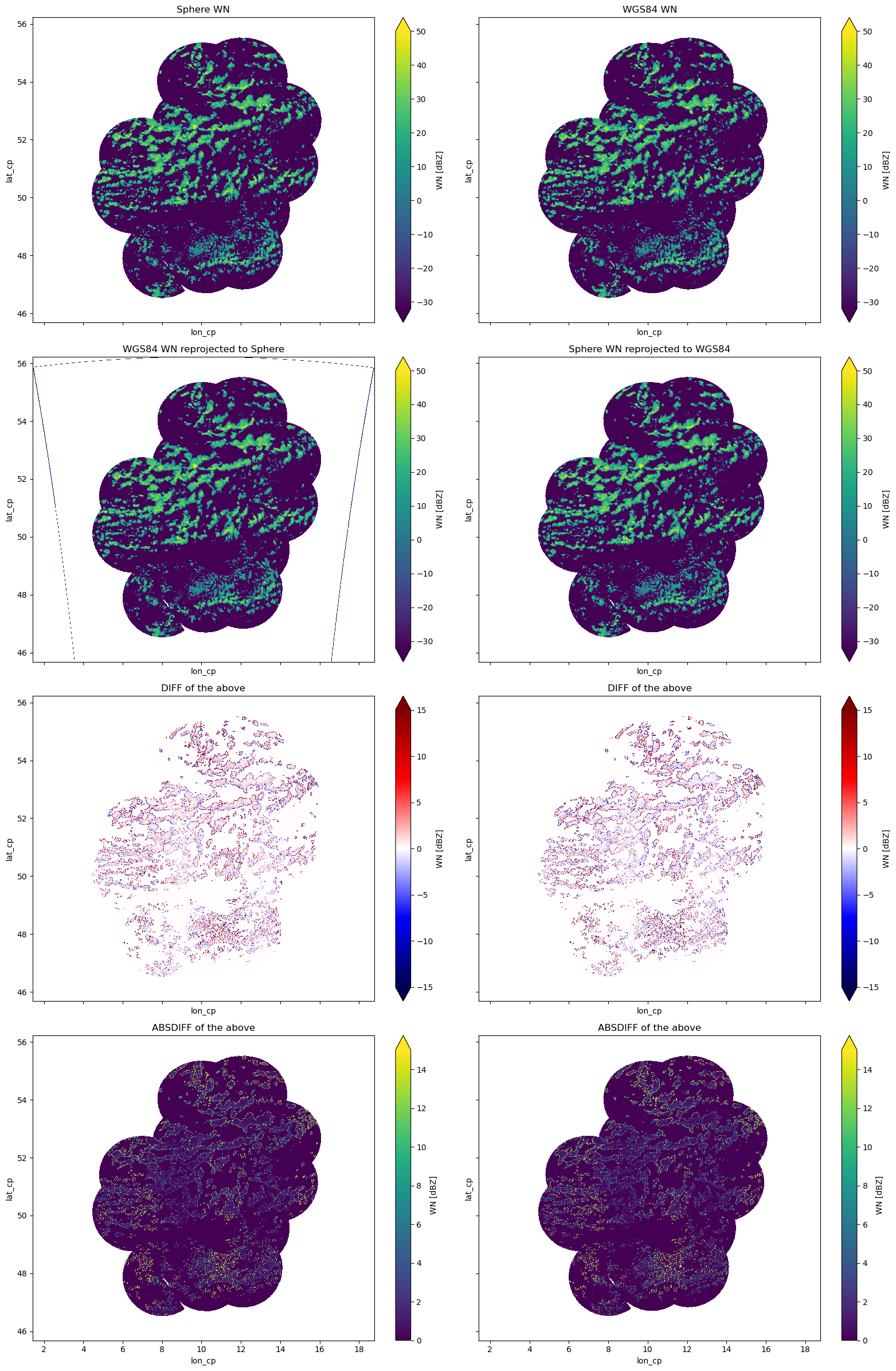
Data: RADOLAN — Deutscher Wetterdienst (DWD). Licensed under CC BY 4.0.