Recipe #2: Reading and visualizing an ODIM_H5 polar volume#
This recipe shows how extract the polar volume data from an ODIM_H5 hdf5 file (KNMI example file from OPERA), contruct a 3-dimensional Cartesian volume and produce a diagnostic plot. The challenge for this file is that for each elevation angle, the scan strategy is different.
[2]:
import datetime as dt
from osgeo import osr

# read the data (sample file in WRADLIB_DATA)
filename = wrl.util.get_wradlib_data_file("hdf5/knmi_polar_volume.h5")

raw_dt = xd.io.open_odim_datatree(filename)
display(raw_dt)
<xarray.DatasetView> Size: 388B
Dimensions:              (sweep: 14)
Dimensions without coordinates: sweep
Data variables:
    volume_number        int64 8B 0
    platform_type        <U5 20B 'fixed'
    instrument_type      <U5 20B 'radar'
    time_coverage_start  <U20 80B '2011-06-10T11:40:02Z'
    time_coverage_end    <U20 80B '2011-06-10T11:43:54Z'
    longitude            float32 4B 4.79
    altitude             float32 4B 50.0
    latitude             float32 4B 52.95
    sweep_fixed_angle    (sweep) float32 56B 0.3 0.4 0.8 1.1 ... 15.0 20.0 25.0
    sweep_group_name     (sweep) int64 112B 0 1 2 3 4 5 6 7 8 9 10 11 12 13
Attributes:
    Conventions:      ODIM_H5/V2_2
    instrument_name:  None
    version:          None
    title:            None
    institution:      None
    references:       None
    source:           None
    history:          None
    comment:          im/exported using xradar
xarray.DataTree
<xarray.DatasetView> Size: 468kB Dimensions: (sweep: 14, azimuth: 360, range: 320) Coordinates: elevation (azimuth) float32 1kB ... time (azimuth) datetime64[ns] 3kB 2011-06-10T11:40:17.36111... * range (range) float32 1kB 500.0 1.5e+03 ... 3.185e+05 3.195e+05 longitude float32 4B ... latitude float32 4B ... altitude float32 4B ... * azimuth (azimuth) float32 1kB 0.5 1.5 2.5 ... 357.5 358.5 359.5 Dimensions without coordinates: sweep Data variables: DBZH (azimuth, range) float32 461kB ... sweep_mode <U20 80B ... sweep_number int64 8B ... prt_mode <U7 28B ... follow_mode <U7 28B ... sweep_fixed_angle float32 4B ...sweep_0- sweep: 14
- azimuth: 360
- range: 320
- elevation(azimuth)float32...
- standard_name :
- ray_elevation_angle
- long_name :
- elevation_angle_from_horizontal_plane
- units :
- degrees
- axis :
- radial_elevation_coordinate
[360 values with dtype=float32]
- time(azimuth)datetime64[ns]2011-06-10T11:40:17.361118208 .....
- standard_name :
- time
array(['2011-06-10T11:40:17.361118208', '2011-06-10T11:40:17.416673792', '2011-06-10T11:40:17.472229376', ..., '2011-06-10T11:40:17.194451456', '2011-06-10T11:40:17.250007040', '2011-06-10T11:40:17.305562624'], dtype='datetime64[ns]') - range(range)float32500.0 1.5e+03 ... 3.195e+05
- units :
- meters
- standard_name :
- projection_range_coordinate
- long_name :
- range_to_measurement_volume
- axis :
- radial_range_coordinate
- meters_between_gates :
- 1000.0
- spacing_is_constant :
- true
- meters_to_center_of_first_gate :
- 500.0
array([ 500., 1500., 2500., ..., 317500., 318500., 319500.], dtype=float32) - longitude()float32...
- long_name :
- longitude
- units :
- degrees_east
- standard_name :
- longitude
[1 values with dtype=float32]
- latitude()float32...
- long_name :
- latitude
- units :
- degrees_north
- positive :
- up
- standard_name :
- latitude
[1 values with dtype=float32]
- altitude()float32...
- long_name :
- altitude
- units :
- meters
- standard_name :
- altitude
[1 values with dtype=float32]
- azimuth(azimuth)float320.5 1.5 2.5 ... 357.5 358.5 359.5
- standard_name :
- ray_azimuth_angle
- long_name :
- azimuth_angle_from_true_north
- units :
- degrees
- axis :
- radial_azimuth_coordinate
array([ 0.5, 1.5, 2.5, ..., 357.5, 358.5, 359.5], dtype=float32)
- DBZH(azimuth, range)float32...
- _Undetect :
- 0.0
- units :
- dBZ
- long_name :
- Equivalent reflectivity factor H
- standard_name :
- radar_equivalent_reflectivity_factor_h
[115200 values with dtype=float32]
- sweep_mode()<U20...
[1 values with dtype=<U20]
- sweep_number()int64...
[1 values with dtype=int64]
- prt_mode()<U7...
[1 values with dtype=<U7]
- follow_mode()<U7...
[1 values with dtype=<U7]
- sweep_fixed_angle()float32...
[1 values with dtype=float32]
<xarray.DatasetView> Size: 352kB Dimensions: (sweep: 14, azimuth: 360, range: 240) Coordinates: elevation (azimuth) float32 1kB ... time (azimuth) datetime64[ns] 3kB 2011-06-10T11:40:36.80555... * range (range) float32 960B 500.0 1.5e+03 ... 2.395e+05 longitude float32 4B ... latitude float32 4B ... altitude float32 4B ... * azimuth (azimuth) float32 1kB 0.5 1.5 2.5 ... 357.5 358.5 359.5 Dimensions without coordinates: sweep Data variables: DBZH (azimuth, range) float32 346kB ... sweep_mode <U20 80B ... sweep_number int64 8B ... prt_mode <U7 28B ... follow_mode <U7 28B ... sweep_fixed_angle float32 4B ...sweep_1- sweep: 14
- azimuth: 360
- range: 240
- elevation(azimuth)float32...
- standard_name :
- ray_elevation_angle
- long_name :
- elevation_angle_from_horizontal_plane
- units :
- degrees
- axis :
- radial_elevation_coordinate
[360 values with dtype=float32]
- time(azimuth)datetime64[ns]2011-06-10T11:40:36.805558272 .....
- standard_name :
- time
array(['2011-06-10T11:40:36.805558272', '2011-06-10T11:40:36.861113856', '2011-06-10T11:40:36.916669440', ..., '2011-06-10T11:40:36.638891520', '2011-06-10T11:40:36.694447104', '2011-06-10T11:40:36.750002688'], dtype='datetime64[ns]') - range(range)float32500.0 1.5e+03 ... 2.395e+05
- units :
- meters
- standard_name :
- projection_range_coordinate
- long_name :
- range_to_measurement_volume
- axis :
- radial_range_coordinate
- meters_between_gates :
- 1000.0
- spacing_is_constant :
- true
- meters_to_center_of_first_gate :
- 500.0
array([ 500., 1500., 2500., ..., 237500., 238500., 239500.], dtype=float32) - longitude()float32...
- long_name :
- longitude
- units :
- degrees_east
- standard_name :
- longitude
[1 values with dtype=float32]
- latitude()float32...
- long_name :
- latitude
- units :
- degrees_north
- positive :
- up
- standard_name :
- latitude
[1 values with dtype=float32]
- altitude()float32...
- long_name :
- altitude
- units :
- meters
- standard_name :
- altitude
[1 values with dtype=float32]
- azimuth(azimuth)float320.5 1.5 2.5 ... 357.5 358.5 359.5
- standard_name :
- ray_azimuth_angle
- long_name :
- azimuth_angle_from_true_north
- units :
- degrees
- axis :
- radial_azimuth_coordinate
array([ 0.5, 1.5, 2.5, ..., 357.5, 358.5, 359.5], dtype=float32)
- DBZH(azimuth, range)float32...
- _Undetect :
- 0.0
- units :
- dBZ
- long_name :
- Equivalent reflectivity factor H
- standard_name :
- radar_equivalent_reflectivity_factor_h
[86400 values with dtype=float32]
- sweep_mode()<U20...
[1 values with dtype=<U20]
- sweep_number()int64...
[1 values with dtype=int64]
- prt_mode()<U7...
[1 values with dtype=<U7]
- follow_mode()<U7...
[1 values with dtype=<U7]
- sweep_fixed_angle()float32...
[1 values with dtype=float32]
<xarray.DatasetView> Size: 352kB Dimensions: (sweep: 14, azimuth: 360, range: 240) Coordinates: elevation (azimuth) float32 1kB ... time (azimuth) datetime64[ns] 3kB 2011-06-10T11:40:56.30555... * range (range) float32 960B 500.0 1.5e+03 ... 2.395e+05 longitude float32 4B ... latitude float32 4B ... altitude float32 4B ... * azimuth (azimuth) float32 1kB 0.5 1.5 2.5 ... 357.5 358.5 359.5 Dimensions without coordinates: sweep Data variables: DBZH (azimuth, range) float32 346kB ... sweep_mode <U20 80B ... sweep_number int64 8B ... prt_mode <U7 28B ... follow_mode <U7 28B ... sweep_fixed_angle float32 4B ...sweep_2- sweep: 14
- azimuth: 360
- range: 240
- elevation(azimuth)float32...
- standard_name :
- ray_elevation_angle
- long_name :
- elevation_angle_from_horizontal_plane
- units :
- degrees
- axis :
- radial_elevation_coordinate
[360 values with dtype=float32]
- time(azimuth)datetime64[ns]2011-06-10T11:40:56.305557504 .....
- standard_name :
- time
array(['2011-06-10T11:40:56.305557504', '2011-06-10T11:40:56.361113088', '2011-06-10T11:40:56.416668672', ..., '2011-06-10T11:40:56.138890752', '2011-06-10T11:40:56.194446336', '2011-06-10T11:40:56.250001920'], dtype='datetime64[ns]') - range(range)float32500.0 1.5e+03 ... 2.395e+05
- units :
- meters
- standard_name :
- projection_range_coordinate
- long_name :
- range_to_measurement_volume
- axis :
- radial_range_coordinate
- meters_between_gates :
- 1000.0
- spacing_is_constant :
- true
- meters_to_center_of_first_gate :
- 500.0
array([ 500., 1500., 2500., ..., 237500., 238500., 239500.], dtype=float32) - longitude()float32...
- long_name :
- longitude
- units :
- degrees_east
- standard_name :
- longitude
[1 values with dtype=float32]
- latitude()float32...
- long_name :
- latitude
- units :
- degrees_north
- positive :
- up
- standard_name :
- latitude
[1 values with dtype=float32]
- altitude()float32...
- long_name :
- altitude
- units :
- meters
- standard_name :
- altitude
[1 values with dtype=float32]
- azimuth(azimuth)float320.5 1.5 2.5 ... 357.5 358.5 359.5
- standard_name :
- ray_azimuth_angle
- long_name :
- azimuth_angle_from_true_north
- units :
- degrees
- axis :
- radial_azimuth_coordinate
array([ 0.5, 1.5, 2.5, ..., 357.5, 358.5, 359.5], dtype=float32)
- DBZH(azimuth, range)float32...
- _Undetect :
- 0.0
- units :
- dBZ
- long_name :
- Equivalent reflectivity factor H
- standard_name :
- radar_equivalent_reflectivity_factor_h
[86400 values with dtype=float32]
- sweep_mode()<U20...
[1 values with dtype=<U20]
- sweep_number()int64...
[1 values with dtype=int64]
- prt_mode()<U7...
[1 values with dtype=<U7]
- follow_mode()<U7...
[1 values with dtype=<U7]
- sweep_fixed_angle()float32...
[1 values with dtype=float32]
<xarray.DatasetView> Size: 352kB Dimensions: (sweep: 14, azimuth: 360, range: 240) Coordinates: elevation (azimuth) float32 1kB ... time (azimuth) datetime64[ns] 3kB 2011-06-10T11:41:15.80555... * range (range) float32 960B 500.0 1.5e+03 ... 2.395e+05 longitude float32 4B ... latitude float32 4B ... altitude float32 4B ... * azimuth (azimuth) float32 1kB 0.5 1.5 2.5 ... 357.5 358.5 359.5 Dimensions without coordinates: sweep Data variables: DBZH (azimuth, range) float32 346kB ... sweep_mode <U20 80B ... sweep_number int64 8B ... prt_mode <U7 28B ... follow_mode <U7 28B ... sweep_fixed_angle float32 4B ...sweep_3- sweep: 14
- azimuth: 360
- range: 240
- elevation(azimuth)float32...
- standard_name :
- ray_elevation_angle
- long_name :
- elevation_angle_from_horizontal_plane
- units :
- degrees
- axis :
- radial_elevation_coordinate
[360 values with dtype=float32]
- time(azimuth)datetime64[ns]2011-06-10T11:41:15.805556736 .....
- standard_name :
- time
array(['2011-06-10T11:41:15.805556736', '2011-06-10T11:41:15.861112320', '2011-06-10T11:41:15.916667904', ..., '2011-06-10T11:41:15.638889984', '2011-06-10T11:41:15.694445568', '2011-06-10T11:41:15.750001152'], dtype='datetime64[ns]') - range(range)float32500.0 1.5e+03 ... 2.395e+05
- units :
- meters
- standard_name :
- projection_range_coordinate
- long_name :
- range_to_measurement_volume
- axis :
- radial_range_coordinate
- meters_between_gates :
- 1000.0
- spacing_is_constant :
- true
- meters_to_center_of_first_gate :
- 500.0
array([ 500., 1500., 2500., ..., 237500., 238500., 239500.], dtype=float32) - longitude()float32...
- long_name :
- longitude
- units :
- degrees_east
- standard_name :
- longitude
[1 values with dtype=float32]
- latitude()float32...
- long_name :
- latitude
- units :
- degrees_north
- positive :
- up
- standard_name :
- latitude
[1 values with dtype=float32]
- altitude()float32...
- long_name :
- altitude
- units :
- meters
- standard_name :
- altitude
[1 values with dtype=float32]
- azimuth(azimuth)float320.5 1.5 2.5 ... 357.5 358.5 359.5
- standard_name :
- ray_azimuth_angle
- long_name :
- azimuth_angle_from_true_north
- units :
- degrees
- axis :
- radial_azimuth_coordinate
array([ 0.5, 1.5, 2.5, ..., 357.5, 358.5, 359.5], dtype=float32)
- DBZH(azimuth, range)float32...
- _Undetect :
- 0.0
- units :
- dBZ
- long_name :
- Equivalent reflectivity factor H
- standard_name :
- radar_equivalent_reflectivity_factor_h
[86400 values with dtype=float32]
- sweep_mode()<U20...
[1 values with dtype=<U20]
- sweep_number()int64...
[1 values with dtype=int64]
- prt_mode()<U7...
[1 values with dtype=<U7]
- follow_mode()<U7...
[1 values with dtype=<U7]
- sweep_fixed_angle()float32...
[1 values with dtype=float32]
<xarray.DatasetView> Size: 352kB Dimensions: (sweep: 14, azimuth: 360, range: 240) Coordinates: elevation (azimuth) float32 1kB ... time (azimuth) datetime64[ns] 3kB 2011-06-10T11:41:36.30555... * range (range) float32 960B 500.0 1.5e+03 ... 2.395e+05 longitude float32 4B ... latitude float32 4B ... altitude float32 4B ... * azimuth (azimuth) float32 1kB 0.5 1.5 2.5 ... 357.5 358.5 359.5 Dimensions without coordinates: sweep Data variables: DBZH (azimuth, range) float32 346kB ... sweep_mode <U20 80B ... sweep_number int64 8B ... prt_mode <U7 28B ... follow_mode <U7 28B ... sweep_fixed_angle float32 4B ...sweep_4- sweep: 14
- azimuth: 360
- range: 240
- elevation(azimuth)float32...
- standard_name :
- ray_elevation_angle
- long_name :
- elevation_angle_from_horizontal_plane
- units :
- degrees
- axis :
- radial_elevation_coordinate
[360 values with dtype=float32]
- time(azimuth)datetime64[ns]2011-06-10T11:41:36.305555968 .....
- standard_name :
- time
array(['2011-06-10T11:41:36.305555968', '2011-06-10T11:41:36.361111552', '2011-06-10T11:41:36.416667136', ..., '2011-06-10T11:41:36.138889216', '2011-06-10T11:41:36.194444800', '2011-06-10T11:41:36.250000384'], dtype='datetime64[ns]') - range(range)float32500.0 1.5e+03 ... 2.395e+05
- units :
- meters
- standard_name :
- projection_range_coordinate
- long_name :
- range_to_measurement_volume
- axis :
- radial_range_coordinate
- meters_between_gates :
- 1000.0
- spacing_is_constant :
- true
- meters_to_center_of_first_gate :
- 500.0
array([ 500., 1500., 2500., ..., 237500., 238500., 239500.], dtype=float32) - longitude()float32...
- long_name :
- longitude
- units :
- degrees_east
- standard_name :
- longitude
[1 values with dtype=float32]
- latitude()float32...
- long_name :
- latitude
- units :
- degrees_north
- positive :
- up
- standard_name :
- latitude
[1 values with dtype=float32]
- altitude()float32...
- long_name :
- altitude
- units :
- meters
- standard_name :
- altitude
[1 values with dtype=float32]
- azimuth(azimuth)float320.5 1.5 2.5 ... 357.5 358.5 359.5
- standard_name :
- ray_azimuth_angle
- long_name :
- azimuth_angle_from_true_north
- units :
- degrees
- axis :
- radial_azimuth_coordinate
array([ 0.5, 1.5, 2.5, ..., 357.5, 358.5, 359.5], dtype=float32)
- DBZH(azimuth, range)float32...
- _Undetect :
- 0.0
- units :
- dBZ
- long_name :
- Equivalent reflectivity factor H
- standard_name :
- radar_equivalent_reflectivity_factor_h
[86400 values with dtype=float32]
- sweep_mode()<U20...
[1 values with dtype=<U20]
- sweep_number()int64...
[1 values with dtype=int64]
- prt_mode()<U7...
[1 values with dtype=<U7]
- follow_mode()<U7...
[1 values with dtype=<U7]
- sweep_fixed_angle()float32...
[1 values with dtype=float32]
<xarray.DatasetView> Size: 497kB Dimensions: (sweep: 14, azimuth: 360, range: 340) Coordinates: elevation (azimuth) float32 1kB ... time (azimuth) datetime64[ns] 3kB 2011-06-10T11:42:10.47919... * range (range) float32 1kB 250.0 750.0 ... 1.692e+05 1.698e+05 longitude float32 4B ... latitude float32 4B ... altitude float32 4B ... * azimuth (azimuth) float32 1kB 0.5 1.5 2.5 ... 357.5 358.5 359.5 Dimensions without coordinates: sweep Data variables: DBZH (azimuth, range) float32 490kB ... sweep_mode <U20 80B ... sweep_number int64 8B ... prt_mode <U7 28B ... follow_mode <U7 28B ... sweep_fixed_angle float32 4B ...sweep_5- sweep: 14
- azimuth: 360
- range: 340
- elevation(azimuth)float32...
- standard_name :
- ray_elevation_angle
- long_name :
- elevation_angle_from_horizontal_plane
- units :
- degrees
- axis :
- radial_elevation_coordinate
[360 values with dtype=float32]
- time(azimuth)datetime64[ns]2011-06-10T11:42:10.479194112 .....
- standard_name :
- time
array(['2011-06-10T11:42:10.479194112', '2011-06-10T11:42:10.520860928', '2011-06-10T11:42:10.562527744', ..., '2011-06-10T11:42:10.354193920', '2011-06-10T11:42:10.395860736', '2011-06-10T11:42:10.437527296'], dtype='datetime64[ns]') - range(range)float32250.0 750.0 ... 1.692e+05 1.698e+05
- units :
- meters
- standard_name :
- projection_range_coordinate
- long_name :
- range_to_measurement_volume
- axis :
- radial_range_coordinate
- meters_between_gates :
- 500.0
- spacing_is_constant :
- true
- meters_to_center_of_first_gate :
- 250.0
array([ 250., 750., 1250., ..., 168750., 169250., 169750.], dtype=float32) - longitude()float32...
- long_name :
- longitude
- units :
- degrees_east
- standard_name :
- longitude
[1 values with dtype=float32]
- latitude()float32...
- long_name :
- latitude
- units :
- degrees_north
- positive :
- up
- standard_name :
- latitude
[1 values with dtype=float32]
- altitude()float32...
- long_name :
- altitude
- units :
- meters
- standard_name :
- altitude
[1 values with dtype=float32]
- azimuth(azimuth)float320.5 1.5 2.5 ... 357.5 358.5 359.5
- standard_name :
- ray_azimuth_angle
- long_name :
- azimuth_angle_from_true_north
- units :
- degrees
- axis :
- radial_azimuth_coordinate
array([ 0.5, 1.5, 2.5, ..., 357.5, 358.5, 359.5], dtype=float32)
- DBZH(azimuth, range)float32...
- _Undetect :
- 0.0
- units :
- dBZ
- long_name :
- Equivalent reflectivity factor H
- standard_name :
- radar_equivalent_reflectivity_factor_h
[122400 values with dtype=float32]
- sweep_mode()<U20...
[1 values with dtype=<U20]
- sweep_number()int64...
[1 values with dtype=int64]
- prt_mode()<U7...
[1 values with dtype=<U7]
- follow_mode()<U7...
[1 values with dtype=<U7]
- sweep_fixed_angle()float32...
[1 values with dtype=float32]
<xarray.DatasetView> Size: 497kB Dimensions: (sweep: 14, azimuth: 360, range: 340) Coordinates: elevation (azimuth) float32 1kB ... time (azimuth) datetime64[ns] 3kB 2011-06-10T11:42:24.77085... * range (range) float32 1kB 250.0 750.0 ... 1.692e+05 1.698e+05 longitude float32 4B ... latitude float32 4B ... altitude float32 4B ... * azimuth (azimuth) float32 1kB 0.5 1.5 2.5 ... 357.5 358.5 359.5 Dimensions without coordinates: sweep Data variables: DBZH (azimuth, range) float32 490kB ... sweep_mode <U20 80B ... sweep_number int64 8B ... prt_mode <U7 28B ... follow_mode <U7 28B ... sweep_fixed_angle float32 4B ...sweep_6- sweep: 14
- azimuth: 360
- range: 340
- elevation(azimuth)float32...
- standard_name :
- ray_elevation_angle
- long_name :
- elevation_angle_from_horizontal_plane
- units :
- degrees
- axis :
- radial_elevation_coordinate
[360 values with dtype=float32]
- time(azimuth)datetime64[ns]2011-06-10T11:42:24.770857472 .....
- standard_name :
- time
array(['2011-06-10T11:42:24.770857472', '2011-06-10T11:42:24.812524288', '2011-06-10T11:42:24.854191104', ..., '2011-06-10T11:42:24.645857280', '2011-06-10T11:42:24.687524096', '2011-06-10T11:42:24.729190912'], dtype='datetime64[ns]') - range(range)float32250.0 750.0 ... 1.692e+05 1.698e+05
- units :
- meters
- standard_name :
- projection_range_coordinate
- long_name :
- range_to_measurement_volume
- axis :
- radial_range_coordinate
- meters_between_gates :
- 500.0
- spacing_is_constant :
- true
- meters_to_center_of_first_gate :
- 250.0
array([ 250., 750., 1250., ..., 168750., 169250., 169750.], dtype=float32) - longitude()float32...
- long_name :
- longitude
- units :
- degrees_east
- standard_name :
- longitude
[1 values with dtype=float32]
- latitude()float32...
- long_name :
- latitude
- units :
- degrees_north
- positive :
- up
- standard_name :
- latitude
[1 values with dtype=float32]
- altitude()float32...
- long_name :
- altitude
- units :
- meters
- standard_name :
- altitude
[1 values with dtype=float32]
- azimuth(azimuth)float320.5 1.5 2.5 ... 357.5 358.5 359.5
- standard_name :
- ray_azimuth_angle
- long_name :
- azimuth_angle_from_true_north
- units :
- degrees
- axis :
- radial_azimuth_coordinate
array([ 0.5, 1.5, 2.5, ..., 357.5, 358.5, 359.5], dtype=float32)
- DBZH(azimuth, range)float32...
- _Undetect :
- 0.0
- units :
- dBZ
- long_name :
- Equivalent reflectivity factor H
- standard_name :
- radar_equivalent_reflectivity_factor_h
[122400 values with dtype=float32]
- sweep_mode()<U20...
[1 values with dtype=<U20]
- sweep_number()int64...
[1 values with dtype=int64]
- prt_mode()<U7...
[1 values with dtype=<U7]
- follow_mode()<U7...
[1 values with dtype=<U7]
- sweep_fixed_angle()float32...
[1 values with dtype=float32]
<xarray.DatasetView> Size: 439kB Dimensions: (sweep: 14, azimuth: 360, range: 300) Coordinates: elevation (azimuth) float32 1kB ... time (azimuth) datetime64[ns] 3kB 2011-06-10T11:42:37.71665... * range (range) float32 1kB 250.0 750.0 ... 1.492e+05 1.498e+05 longitude float32 4B ... latitude float32 4B ... altitude float32 4B ... * azimuth (azimuth) float32 1kB 0.5 1.5 2.5 ... 357.5 358.5 359.5 Dimensions without coordinates: sweep Data variables: DBZH (azimuth, range) float32 432kB ... sweep_mode <U20 80B ... sweep_number int64 8B ... prt_mode <U7 28B ... follow_mode <U7 28B ... sweep_fixed_angle float32 4B ...sweep_7- sweep: 14
- azimuth: 360
- range: 300
- elevation(azimuth)float32...
- standard_name :
- ray_elevation_angle
- long_name :
- elevation_angle_from_horizontal_plane
- units :
- degrees
- axis :
- radial_elevation_coordinate
[360 values with dtype=float32]
- time(azimuth)datetime64[ns]2011-06-10T11:42:37.716658432 .....
- standard_name :
- time
array(['2011-06-10T11:42:37.716658432', '2011-06-10T11:42:37.749991680', '2011-06-10T11:42:37.783324928', ..., '2011-06-10T11:42:37.616658432', '2011-06-10T11:42:37.649991680', '2011-06-10T11:42:37.683324928'], dtype='datetime64[ns]') - range(range)float32250.0 750.0 ... 1.492e+05 1.498e+05
- units :
- meters
- standard_name :
- projection_range_coordinate
- long_name :
- range_to_measurement_volume
- axis :
- radial_range_coordinate
- meters_between_gates :
- 500.0
- spacing_is_constant :
- true
- meters_to_center_of_first_gate :
- 250.0
array([ 250., 750., 1250., ..., 148750., 149250., 149750.], dtype=float32) - longitude()float32...
- long_name :
- longitude
- units :
- degrees_east
- standard_name :
- longitude
[1 values with dtype=float32]
- latitude()float32...
- long_name :
- latitude
- units :
- degrees_north
- positive :
- up
- standard_name :
- latitude
[1 values with dtype=float32]
- altitude()float32...
- long_name :
- altitude
- units :
- meters
- standard_name :
- altitude
[1 values with dtype=float32]
- azimuth(azimuth)float320.5 1.5 2.5 ... 357.5 358.5 359.5
- standard_name :
- ray_azimuth_angle
- long_name :
- azimuth_angle_from_true_north
- units :
- degrees
- axis :
- radial_azimuth_coordinate
array([ 0.5, 1.5, 2.5, ..., 357.5, 358.5, 359.5], dtype=float32)
- DBZH(azimuth, range)float32...
- _Undetect :
- 0.0
- units :
- dBZ
- long_name :
- Equivalent reflectivity factor H
- standard_name :
- radar_equivalent_reflectivity_factor_h
[108000 values with dtype=float32]
- sweep_mode()<U20...
[1 values with dtype=<U20]
- sweep_number()int64...
[1 values with dtype=int64]
- prt_mode()<U7...
[1 values with dtype=<U7]
- follow_mode()<U7...
[1 values with dtype=<U7]
- sweep_fixed_angle()float32...
[1 values with dtype=float32]
<xarray.DatasetView> Size: 439kB Dimensions: (sweep: 14, azimuth: 360, range: 300) Coordinates: elevation (azimuth) float32 1kB ... time (azimuth) datetime64[ns] 3kB 2011-06-10T11:42:49.01665... * range (range) float32 1kB 250.0 750.0 ... 1.492e+05 1.498e+05 longitude float32 4B ... latitude float32 4B ... altitude float32 4B ... * azimuth (azimuth) float32 1kB 0.5 1.5 2.5 ... 357.5 358.5 359.5 Dimensions without coordinates: sweep Data variables: DBZH (azimuth, range) float32 432kB ... sweep_mode <U20 80B ... sweep_number int64 8B ... prt_mode <U7 28B ... follow_mode <U7 28B ... sweep_fixed_angle float32 4B ...sweep_8- sweep: 14
- azimuth: 360
- range: 300
- elevation(azimuth)float32...
- standard_name :
- ray_elevation_angle
- long_name :
- elevation_angle_from_horizontal_plane
- units :
- degrees
- axis :
- radial_elevation_coordinate
[360 values with dtype=float32]
- time(azimuth)datetime64[ns]2011-06-10T11:42:49.016659968 .....
- standard_name :
- time
array(['2011-06-10T11:42:49.016659968', '2011-06-10T11:42:49.049993216', '2011-06-10T11:42:49.083326464', ..., '2011-06-10T11:42:48.916659968', '2011-06-10T11:42:48.949993472', '2011-06-10T11:42:48.983326720'], dtype='datetime64[ns]') - range(range)float32250.0 750.0 ... 1.492e+05 1.498e+05
- units :
- meters
- standard_name :
- projection_range_coordinate
- long_name :
- range_to_measurement_volume
- axis :
- radial_range_coordinate
- meters_between_gates :
- 500.0
- spacing_is_constant :
- true
- meters_to_center_of_first_gate :
- 250.0
array([ 250., 750., 1250., ..., 148750., 149250., 149750.], dtype=float32) - longitude()float32...
- long_name :
- longitude
- units :
- degrees_east
- standard_name :
- longitude
[1 values with dtype=float32]
- latitude()float32...
- long_name :
- latitude
- units :
- degrees_north
- positive :
- up
- standard_name :
- latitude
[1 values with dtype=float32]
- altitude()float32...
- long_name :
- altitude
- units :
- meters
- standard_name :
- altitude
[1 values with dtype=float32]
- azimuth(azimuth)float320.5 1.5 2.5 ... 357.5 358.5 359.5
- standard_name :
- ray_azimuth_angle
- long_name :
- azimuth_angle_from_true_north
- units :
- degrees
- axis :
- radial_azimuth_coordinate
array([ 0.5, 1.5, 2.5, ..., 357.5, 358.5, 359.5], dtype=float32)
- DBZH(azimuth, range)float32...
- _Undetect :
- 0.0
- units :
- dBZ
- long_name :
- Equivalent reflectivity factor H
- standard_name :
- radar_equivalent_reflectivity_factor_h
[108000 values with dtype=float32]
- sweep_mode()<U20...
[1 values with dtype=<U20]
- sweep_number()int64...
[1 values with dtype=int64]
- prt_mode()<U7...
[1 values with dtype=<U7]
- follow_mode()<U7...
[1 values with dtype=<U7]
- sweep_fixed_angle()float32...
[1 values with dtype=float32]
<xarray.DatasetView> Size: 352kB Dimensions: (sweep: 14, azimuth: 360, range: 240) Coordinates: elevation (azimuth) float32 1kB ... time (azimuth) datetime64[ns] 3kB 2011-06-10T11:42:59.79165... * range (range) float32 960B 250.0 750.0 ... 1.192e+05 1.198e+05 longitude float32 4B ... latitude float32 4B ... altitude float32 4B ... * azimuth (azimuth) float32 1kB 0.5 1.5 2.5 ... 357.5 358.5 359.5 Dimensions without coordinates: sweep Data variables: DBZH (azimuth, range) float32 346kB ... sweep_mode <U20 80B ... sweep_number int64 8B ... prt_mode <U7 28B ... follow_mode <U7 28B ... sweep_fixed_angle float32 4B ...sweep_9- sweep: 14
- azimuth: 360
- range: 240
- elevation(azimuth)float32...
- standard_name :
- ray_elevation_angle
- long_name :
- elevation_angle_from_horizontal_plane
- units :
- degrees
- axis :
- radial_elevation_coordinate
[360 values with dtype=float32]
- time(azimuth)datetime64[ns]2011-06-10T11:42:59.791652096 .....
- standard_name :
- time
array(['2011-06-10T11:42:59.791652096', '2011-06-10T11:42:59.819429888', '2011-06-10T11:42:59.847207424', ..., '2011-06-10T11:42:59.708319232', '2011-06-10T11:42:59.736096768', '2011-06-10T11:42:59.763874560'], dtype='datetime64[ns]') - range(range)float32250.0 750.0 ... 1.192e+05 1.198e+05
- units :
- meters
- standard_name :
- projection_range_coordinate
- long_name :
- range_to_measurement_volume
- axis :
- radial_range_coordinate
- meters_between_gates :
- 500.0
- spacing_is_constant :
- true
- meters_to_center_of_first_gate :
- 250.0
array([ 250., 750., 1250., ..., 118750., 119250., 119750.], dtype=float32) - longitude()float32...
- long_name :
- longitude
- units :
- degrees_east
- standard_name :
- longitude
[1 values with dtype=float32]
- latitude()float32...
- long_name :
- latitude
- units :
- degrees_north
- positive :
- up
- standard_name :
- latitude
[1 values with dtype=float32]
- altitude()float32...
- long_name :
- altitude
- units :
- meters
- standard_name :
- altitude
[1 values with dtype=float32]
- azimuth(azimuth)float320.5 1.5 2.5 ... 357.5 358.5 359.5
- standard_name :
- ray_azimuth_angle
- long_name :
- azimuth_angle_from_true_north
- units :
- degrees
- axis :
- radial_azimuth_coordinate
array([ 0.5, 1.5, 2.5, ..., 357.5, 358.5, 359.5], dtype=float32)
- DBZH(azimuth, range)float32...
- _Undetect :
- 0.0
- units :
- dBZ
- long_name :
- Equivalent reflectivity factor H
- standard_name :
- radar_equivalent_reflectivity_factor_h
[86400 values with dtype=float32]
- sweep_mode()<U20...
[1 values with dtype=<U20]
- sweep_number()int64...
[1 values with dtype=int64]
- prt_mode()<U7...
[1 values with dtype=<U7]
- follow_mode()<U7...
[1 values with dtype=<U7]
- sweep_fixed_angle()float32...
[1 values with dtype=float32]
<xarray.DatasetView> Size: 352kB Dimensions: (sweep: 14, azimuth: 360, range: 240) Coordinates: elevation (azimuth) float32 1kB ... time (azimuth) datetime64[ns] 3kB 2011-06-10T11:43:09.54166... * range (range) float32 960B 250.0 750.0 ... 1.192e+05 1.198e+05 longitude float32 4B ... latitude float32 4B ... altitude float32 4B ... * azimuth (azimuth) float32 1kB 0.5 1.5 2.5 ... 357.5 358.5 359.5 Dimensions without coordinates: sweep Data variables: DBZH (azimuth, range) float32 346kB ... sweep_mode <U20 80B ... sweep_number int64 8B ... prt_mode <U7 28B ... follow_mode <U7 28B ... sweep_fixed_angle float32 4B ...sweep_10- sweep: 14
- azimuth: 360
- range: 240
- elevation(azimuth)float32...
- standard_name :
- ray_elevation_angle
- long_name :
- elevation_angle_from_horizontal_plane
- units :
- degrees
- axis :
- radial_elevation_coordinate
[360 values with dtype=float32]
- time(azimuth)datetime64[ns]2011-06-10T11:43:09.541660672 .....
- standard_name :
- time
array(['2011-06-10T11:43:09.541660672', '2011-06-10T11:43:09.569438464', '2011-06-10T11:43:09.597216256', ..., '2011-06-10T11:43:09.458327808', '2011-06-10T11:43:09.486105344', '2011-06-10T11:43:09.513883136'], dtype='datetime64[ns]') - range(range)float32250.0 750.0 ... 1.192e+05 1.198e+05
- units :
- meters
- standard_name :
- projection_range_coordinate
- long_name :
- range_to_measurement_volume
- axis :
- radial_range_coordinate
- meters_between_gates :
- 500.0
- spacing_is_constant :
- true
- meters_to_center_of_first_gate :
- 250.0
array([ 250., 750., 1250., ..., 118750., 119250., 119750.], dtype=float32) - longitude()float32...
- long_name :
- longitude
- units :
- degrees_east
- standard_name :
- longitude
[1 values with dtype=float32]
- latitude()float32...
- long_name :
- latitude
- units :
- degrees_north
- positive :
- up
- standard_name :
- latitude
[1 values with dtype=float32]
- altitude()float32...
- long_name :
- altitude
- units :
- meters
- standard_name :
- altitude
[1 values with dtype=float32]
- azimuth(azimuth)float320.5 1.5 2.5 ... 357.5 358.5 359.5
- standard_name :
- ray_azimuth_angle
- long_name :
- azimuth_angle_from_true_north
- units :
- degrees
- axis :
- radial_azimuth_coordinate
array([ 0.5, 1.5, 2.5, ..., 357.5, 358.5, 359.5], dtype=float32)
- DBZH(azimuth, range)float32...
- _Undetect :
- 0.0
- units :
- dBZ
- long_name :
- Equivalent reflectivity factor H
- standard_name :
- radar_equivalent_reflectivity_factor_h
[86400 values with dtype=float32]
- sweep_mode()<U20...
[1 values with dtype=<U20]
- sweep_number()int64...
[1 values with dtype=int64]
- prt_mode()<U7...
[1 values with dtype=<U7]
- follow_mode()<U7...
[1 values with dtype=<U7]
- sweep_fixed_angle()float32...
[1 values with dtype=float32]
<xarray.DatasetView> Size: 352kB Dimensions: (sweep: 14, azimuth: 360, range: 240) Coordinates: elevation (azimuth) float32 1kB ... time (azimuth) datetime64[ns] 3kB 2011-06-10T11:43:29.87496... * range (range) float32 960B 250.0 750.0 ... 1.192e+05 1.198e+05 longitude float32 4B ... latitude float32 4B ... altitude float32 4B ... * azimuth (azimuth) float32 1kB 0.5 1.5 2.5 ... 357.5 358.5 359.5 Dimensions without coordinates: sweep Data variables: DBZH (azimuth, range) float32 346kB ... sweep_mode <U20 80B ... sweep_number int64 8B ... prt_mode <U7 28B ... follow_mode <U7 28B ... sweep_fixed_angle float32 4B ...sweep_11- sweep: 14
- azimuth: 360
- range: 240
- elevation(azimuth)float32...
- standard_name :
- ray_elevation_angle
- long_name :
- elevation_angle_from_horizontal_plane
- units :
- degrees
- axis :
- radial_elevation_coordinate
[360 values with dtype=float32]
- time(azimuth)datetime64[ns]2011-06-10T11:43:29.874966272 .....
- standard_name :
- time
array(['2011-06-10T11:43:29.874966272', '2011-06-10T11:43:29.902743808', '2011-06-10T11:43:29.930521600', ..., '2011-06-10T11:43:29.791633152', '2011-06-10T11:43:29.819410688', '2011-06-10T11:43:29.847188480'], dtype='datetime64[ns]') - range(range)float32250.0 750.0 ... 1.192e+05 1.198e+05
- units :
- meters
- standard_name :
- projection_range_coordinate
- long_name :
- range_to_measurement_volume
- axis :
- radial_range_coordinate
- meters_between_gates :
- 500.0
- spacing_is_constant :
- true
- meters_to_center_of_first_gate :
- 250.0
array([ 250., 750., 1250., ..., 118750., 119250., 119750.], dtype=float32) - longitude()float32...
- long_name :
- longitude
- units :
- degrees_east
- standard_name :
- longitude
[1 values with dtype=float32]
- latitude()float32...
- long_name :
- latitude
- units :
- degrees_north
- positive :
- up
- standard_name :
- latitude
[1 values with dtype=float32]
- altitude()float32...
- long_name :
- altitude
- units :
- meters
- standard_name :
- altitude
[1 values with dtype=float32]
- azimuth(azimuth)float320.5 1.5 2.5 ... 357.5 358.5 359.5
- standard_name :
- ray_azimuth_angle
- long_name :
- azimuth_angle_from_true_north
- units :
- degrees
- axis :
- radial_azimuth_coordinate
array([ 0.5, 1.5, 2.5, ..., 357.5, 358.5, 359.5], dtype=float32)
- DBZH(azimuth, range)float32...
- _Undetect :
- 0.0
- units :
- dBZ
- long_name :
- Equivalent reflectivity factor H
- standard_name :
- radar_equivalent_reflectivity_factor_h
[86400 values with dtype=float32]
- sweep_mode()<U20...
[1 values with dtype=<U20]
- sweep_number()int64...
[1 values with dtype=int64]
- prt_mode()<U7...
[1 values with dtype=<U7]
- follow_mode()<U7...
[1 values with dtype=<U7]
- sweep_fixed_angle()float32...
[1 values with dtype=float32]
<xarray.DatasetView> Size: 352kB Dimensions: (sweep: 14, azimuth: 360, range: 240) Coordinates: elevation (azimuth) float32 1kB ... time (azimuth) datetime64[ns] 3kB 2011-06-10T11:43:39.23608... * range (range) float32 960B 250.0 750.0 ... 1.192e+05 1.198e+05 longitude float32 4B ... latitude float32 4B ... altitude float32 4B ... * azimuth (azimuth) float32 1kB 0.5 1.5 2.5 ... 357.5 358.5 359.5 Dimensions without coordinates: sweep Data variables: DBZH (azimuth, range) float32 346kB ... sweep_mode <U20 80B ... sweep_number int64 8B ... prt_mode <U7 28B ... follow_mode <U7 28B ... sweep_fixed_angle float32 4B ...sweep_12- sweep: 14
- azimuth: 360
- range: 240
- elevation(azimuth)float32...
- standard_name :
- ray_elevation_angle
- long_name :
- elevation_angle_from_horizontal_plane
- units :
- degrees
- axis :
- radial_elevation_coordinate
[360 values with dtype=float32]
- time(azimuth)datetime64[ns]2011-06-10T11:43:39.236087296 .....
- standard_name :
- time
array(['2011-06-10T11:43:39.236087296', '2011-06-10T11:43:39.263865088', '2011-06-10T11:43:39.291642624', ..., '2011-06-10T11:43:39.152754432', '2011-06-10T11:43:39.180531968', '2011-06-10T11:43:39.208309760'], dtype='datetime64[ns]') - range(range)float32250.0 750.0 ... 1.192e+05 1.198e+05
- units :
- meters
- standard_name :
- projection_range_coordinate
- long_name :
- range_to_measurement_volume
- axis :
- radial_range_coordinate
- meters_between_gates :
- 500.0
- spacing_is_constant :
- true
- meters_to_center_of_first_gate :
- 250.0
array([ 250., 750., 1250., ..., 118750., 119250., 119750.], dtype=float32) - longitude()float32...
- long_name :
- longitude
- units :
- degrees_east
- standard_name :
- longitude
[1 values with dtype=float32]
- latitude()float32...
- long_name :
- latitude
- units :
- degrees_north
- positive :
- up
- standard_name :
- latitude
[1 values with dtype=float32]
- altitude()float32...
- long_name :
- altitude
- units :
- meters
- standard_name :
- altitude
[1 values with dtype=float32]
- azimuth(azimuth)float320.5 1.5 2.5 ... 357.5 358.5 359.5
- standard_name :
- ray_azimuth_angle
- long_name :
- azimuth_angle_from_true_north
- units :
- degrees
- axis :
- radial_azimuth_coordinate
array([ 0.5, 1.5, 2.5, ..., 357.5, 358.5, 359.5], dtype=float32)
- DBZH(azimuth, range)float32...
- _Undetect :
- 0.0
- units :
- dBZ
- long_name :
- Equivalent reflectivity factor H
- standard_name :
- radar_equivalent_reflectivity_factor_h
[86400 values with dtype=float32]
- sweep_mode()<U20...
[1 values with dtype=<U20]
- sweep_number()int64...
[1 values with dtype=int64]
- prt_mode()<U7...
[1 values with dtype=<U7]
- follow_mode()<U7...
[1 values with dtype=<U7]
- sweep_fixed_angle()float32...
[1 values with dtype=float32]
<xarray.DatasetView> Size: 352kB Dimensions: (sweep: 14, azimuth: 360, range: 240) Coordinates: elevation (azimuth) float32 1kB ... time (azimuth) datetime64[ns] 3kB 2011-06-10T11:43:48.76387... * range (range) float32 960B 250.0 750.0 ... 1.192e+05 1.198e+05 longitude float32 4B ... latitude float32 4B ... altitude float32 4B ... * azimuth (azimuth) float32 1kB 0.5 1.5 2.5 ... 357.5 358.5 359.5 Dimensions without coordinates: sweep Data variables: DBZH (azimuth, range) float32 346kB ... sweep_mode <U20 80B ... sweep_number int64 8B ... prt_mode <U7 28B ... follow_mode <U7 28B ... sweep_fixed_angle float32 4B ...sweep_13- sweep: 14
- azimuth: 360
- range: 240
- elevation(azimuth)float32...
- standard_name :
- ray_elevation_angle
- long_name :
- elevation_angle_from_horizontal_plane
- units :
- degrees
- axis :
- radial_elevation_coordinate
[360 values with dtype=float32]
- time(azimuth)datetime64[ns]2011-06-10T11:43:48.763874560 .....
- standard_name :
- time
array(['2011-06-10T11:43:48.763874560', '2011-06-10T11:43:48.791652096', '2011-06-10T11:43:48.819429888', ..., '2011-06-10T11:43:48.680541440', '2011-06-10T11:43:48.708319232', '2011-06-10T11:43:48.736096768'], dtype='datetime64[ns]') - range(range)float32250.0 750.0 ... 1.192e+05 1.198e+05
- units :
- meters
- standard_name :
- projection_range_coordinate
- long_name :
- range_to_measurement_volume
- axis :
- radial_range_coordinate
- meters_between_gates :
- 500.0
- spacing_is_constant :
- true
- meters_to_center_of_first_gate :
- 250.0
array([ 250., 750., 1250., ..., 118750., 119250., 119750.], dtype=float32) - longitude()float32...
- long_name :
- longitude
- units :
- degrees_east
- standard_name :
- longitude
[1 values with dtype=float32]
- latitude()float32...
- long_name :
- latitude
- units :
- degrees_north
- positive :
- up
- standard_name :
- latitude
[1 values with dtype=float32]
- altitude()float32...
- long_name :
- altitude
- units :
- meters
- standard_name :
- altitude
[1 values with dtype=float32]
- azimuth(azimuth)float320.5 1.5 2.5 ... 357.5 358.5 359.5
- standard_name :
- ray_azimuth_angle
- long_name :
- azimuth_angle_from_true_north
- units :
- degrees
- axis :
- radial_azimuth_coordinate
array([ 0.5, 1.5, 2.5, ..., 357.5, 358.5, 359.5], dtype=float32)
- DBZH(azimuth, range)float32...
- _Undetect :
- 0.0
- units :
- dBZ
- long_name :
- Equivalent reflectivity factor H
- standard_name :
- radar_equivalent_reflectivity_factor_h
[86400 values with dtype=float32]
- sweep_mode()<U20...
[1 values with dtype=<U20]
- sweep_number()int64...
[1 values with dtype=int64]
- prt_mode()<U7...
[1 values with dtype=<U7]
- follow_mode()<U7...
[1 values with dtype=<U7]
- sweep_fixed_angle()float32...
[1 values with dtype=float32]
<xarray.DatasetView> Size: 12B Dimensions: (sweep: 14) Coordinates: longitude float32 4B 4.79 latitude float32 4B 52.95 altitude float32 4B 50.0 Dimensions without coordinates: sweep Data variables: *empty*radar_parameters- sweep: 14
- longitude()float324.79
- long_name :
- longitude
- units :
- degrees_east
- standard_name :
- longitude
array(4.78997, dtype=float32)
- latitude()float3252.95
- long_name :
- latitude
- units :
- degrees_north
- positive :
- up
- standard_name :
- latitude
array(52.95334, dtype=float32)
- altitude()float3250.0
- long_name :
- altitude
- units :
- meters
- standard_name :
- altitude
array(50., dtype=float32)
<xarray.DatasetView> Size: 12B Dimensions: (sweep: 14) Coordinates: longitude float32 4B 4.79 latitude float32 4B 52.95 altitude float32 4B 50.0 Dimensions without coordinates: sweep Data variables: *empty*georeferencing_correction- sweep: 14
- longitude()float324.79
- long_name :
- longitude
- units :
- degrees_east
- standard_name :
- longitude
array(4.78997, dtype=float32)
- latitude()float3252.95
- long_name :
- latitude
- units :
- degrees_north
- positive :
- up
- standard_name :
- latitude
array(52.95334, dtype=float32)
- altitude()float3250.0
- long_name :
- altitude
- units :
- meters
- standard_name :
- altitude
array(50., dtype=float32)
<xarray.DatasetView> Size: 0B Dimensions: (sweep: 14) Dimensions without coordinates: sweep Data variables: *empty*radar_calibration- sweep: 14
- sweep: 14
- volume_number()int640
array(0)
- platform_type()<U5'fixed'
array('fixed', dtype='<U5') - instrument_type()<U5'radar'
array('radar', dtype='<U5') - time_coverage_start()<U20'2011-06-10T11:40:02Z'
array('2011-06-10T11:40:02Z', dtype='<U20') - time_coverage_end()<U20'2011-06-10T11:43:54Z'
array('2011-06-10T11:43:54Z', dtype='<U20') - longitude()float324.79
- long_name :
- longitude
- units :
- degrees_east
- standard_name :
- longitude
array(4.78997, dtype=float32)
- altitude()float3250.0
- long_name :
- altitude
- units :
- meters
- standard_name :
- altitude
array(50., dtype=float32)
- latitude()float3252.95
- long_name :
- latitude
- units :
- degrees_north
- positive :
- up
- standard_name :
- latitude
array(52.95334, dtype=float32)
- sweep_fixed_angle(sweep)float320.3 0.4 0.8 1.1 ... 15.0 20.0 25.0
array([ 0.3, 0.4, 0.8, 1.1, 2. , 3. , 4.5, 6. , 8. , 10. , 12. , 15. , 20. , 25. ], dtype=float32) - sweep_group_name(sweep)int640 1 2 3 4 5 6 7 8 9 10 11 12 13
array([ 0, 1, 2, 3, 4, 5, 6, 7, 8, 9, 10, 11, 12, 13])
- Conventions :
- ODIM_H5/V2_2
- instrument_name :
- None
- version :
- None
- title :
- None
- institution :
- None
- references :
- None
- source :
- None
- history :
- None
- comment :
- im/exported using xradar
[3]:
proj = osr.SpatialReference()
proj.ImportFromEPSG(32632)
for key in list(raw_dt.children):
    if "sweep" in key:
        raw_dt[key].ds = raw_dt[key].ds.wrl.georef.georeference(crs=proj)
[4]:
swp_list = []
for key in list(raw_dt.children):
    if "sweep" in key:
        ds = raw_dt[key].ds
        xyz = (
            xr.concat(
                [
                    ds.coords["x"].reset_coords(drop=True),
                    ds.coords["y"].reset_coords(drop=True),
                    ds.coords["z"].reset_coords(drop=True),
                ],
                "xyz",
            )
            .stack(npoints=("azimuth", "range"))
            .transpose(..., "xyz")
        )
        swp_list.append(xyz)
xyz = xr.concat(swp_list, "npoints")
[5]:
swp_list[0]
[5]:
<xarray.DataArray 'x' (npoints: 115200, xyz: 3)> Size: 3MB
array([[2.17262259e+05, 5.87587733e+06, 5.26327115e+01],
       [2.17329665e+05, 5.87687562e+06, 5.79865115e+01],
       [2.17397078e+05, 5.87787390e+06, 6.34581474e+01],
       ...,
       [2.33423522e+05, 6.19241546e+06, 7.64849169e+03],
       [2.33475527e+05, 6.19341275e+06, 7.69116241e+03],
       [2.33527539e+05, 6.19441005e+06, 7.73395058e+03]])
Coordinates:
  * npoints  (npoints) object 922kB MultiIndex
  * azimuth  (npoints) float32 461kB 0.5 0.5 0.5 0.5 ... 359.5 359.5 359.5 359.5
  * range    (npoints) float32 461kB 500.0 1.5e+03 ... 3.185e+05 3.195e+05
Dimensions without coordinates: xyz
Attributes:
    standard_name:  east_west_distance_from_radar
    units:          meters
xarray.DataArray
'x'
- npoints: 115200
- xyz: 3
- 2.173e+05 5.876e+06 52.63 2.173e+05 ... 2.335e+05 6.194e+06 7.734e+03
array([[2.17262259e+05, 5.87587733e+06, 5.26327115e+01], [2.17329665e+05, 5.87687562e+06, 5.79865115e+01], [2.17397078e+05, 5.87787390e+06, 6.34581474e+01], ..., [2.33423522e+05, 6.19241546e+06, 7.64849169e+03], [2.33475527e+05, 6.19341275e+06, 7.69116241e+03], [2.33527539e+05, 6.19441005e+06, 7.73395058e+03]]) - npoints(npoints)objectMultiIndex
array([(0.5, 500.0), (0.5, 1500.0), (0.5, 2500.0), ..., (359.5, 317500.0), (359.5, 318500.0), (359.5, 319500.0)], dtype=object) - azimuth(npoints)float320.5 0.5 0.5 ... 359.5 359.5 359.5
- standard_name :
- ray_azimuth_angle
- long_name :
- azimuth_angle_from_true_north
- units :
- degrees
- axis :
- radial_azimuth_coordinate
array([ 0.5, 0.5, 0.5, ..., 359.5, 359.5, 359.5], dtype=float32)
- range(npoints)float32500.0 1.5e+03 ... 3.195e+05
- units :
- meters
- standard_name :
- projection_range_coordinate
- long_name :
- range_to_measurement_volume
- axis :
- radial_range_coordinate
- meters_between_gates :
- 1000.0
- spacing_is_constant :
- true
- meters_to_center_of_first_gate :
- 500.0
array([   500.,   1500.,   2500., ..., 317500., 318500., 319500.],
      dtype=float32)
- npoints
azimuth
rangePandasMultiIndexPandasIndex(MultiIndex([( 0.5, 500.0), ( 0.5, 1500.0), ( 0.5, 2500.0), ( 0.5, 3500.0), ( 0.5, 4500.0), ( 0.5, 5500.0), ( 0.5, 6500.0), ( 0.5, 7500.0), ( 0.5, 8500.0), ( 0.5, 9500.0), ... (359.5, 310500.0), (359.5, 311500.0), (359.5, 312500.0), (359.5, 313500.0), (359.5, 314500.0), (359.5, 315500.0), (359.5, 316500.0), (359.5, 317500.0), (359.5, 318500.0), (359.5, 319500.0)], name='npoints', length=115200))
- standard_name :
- east_west_distance_from_radar
- units :
- meters
[6]:
data_list = []
for key in list(raw_dt.children):
    if "sweep" in key:
        ds = raw_dt[key].ds
        data = ds.DBZH.stack(npoints=("azimuth", "range"))
        data_list.append(data)
data = xr.concat(data_list, "npoints")
[7]:
# generate 3-D Cartesian target grid coordinates
sitecoords = (raw_dt.longitude.values, raw_dt.latitude.values, raw_dt.altitude.values)
maxrange = 200000.0
minelev = 0.1
maxelev = 25.0
maxalt = 5000.0
horiz_res = 2000.0
vert_res = 250.0
trgxyz, trgshape = wrl.vpr.make_3d_grid(
    sitecoords, proj, maxrange, maxalt, horiz_res, vert_res
)
[8]:
# interpolate to Cartesian 3-D volume grid
tstart = dt.datetime.now()
gridder = wrl.vpr.CAPPI(
    xyz.values,
    trgxyz,
    # gridshape=trgshape,
    maxrange=maxrange,
    minelev=minelev,
    maxelev=maxelev,
)
vol = np.ma.masked_invalid(gridder(data.values).reshape(trgshape))
print("3-D interpolation took:", dt.datetime.now() - tstart)
3-D interpolation took: 0:00:00.701437
[9]:
# diagnostic plot
trgx = trgxyz[:, 0].reshape(trgshape)[0, 0, :]
trgy = trgxyz[:, 1].reshape(trgshape)[0, :, 0]
trgz = trgxyz[:, 2].reshape(trgshape)[:, 0, 0]
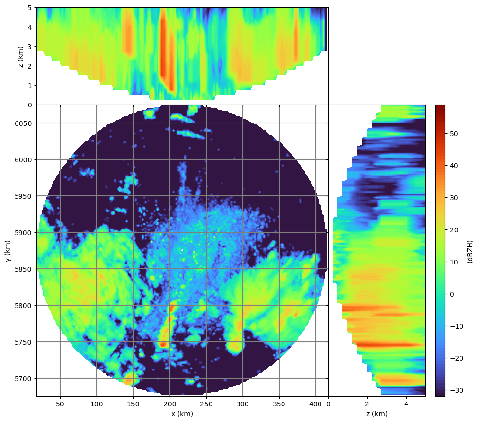
wrl.vis.plot_max_plan_and_vert(
trgx,
trgy,
trgz,
vol,
unit="dBZH",
levels=range(-32, 60),
cmap="turbo",
)
Note
In order to run the recipe code, you need to extract the sample data into a directory pointed to by environment variable WRADLIB_DATA.