Clutter detection by using space-born cloud images#
[1]:
import numpy as np

import xarray as xr
import xradar as xd
import wradlib as wrl
import matplotlib.pyplot as plt
from osgeo import osr

try:
    get_ipython().run_line_magic("matplotlib inline")
except:
    plt.ion()
Read the radar data into DataTree#
[2]:
# read the radar volume scan
filename = "hdf5/20130429043000.rad.bewid.pvol.dbzh.scan1.hdf"
filename = wrl.util.get_wradlib_data_file(filename)
pvol = xd.io.open_odim_datatree(filename)
display(pvol)
/home/runner/micromamba/envs/wradlib-notebooks/lib/python3.12/site-packages/wradlib_data/__init__.py:4: DeprecationWarning: pkg_resources is deprecated as an API. See https://setuptools.pypa.io/en/latest/pkg_resources.html
  from pkg_resources import DistributionNotFound, get_distribution
Downloading file 'hdf5/20130429043000.rad.bewid.pvol.dbzh.scan1.hdf' from 'https://github.com/wradlib/wradlib-data/raw/pooch/data/hdf5/20130429043000.rad.bewid.pvol.dbzh.scan1.hdf' to '/home/runner/work/wradlib-notebooks/wradlib-notebooks/wradlib-data'.
<xarray.DatasetView> Size: 312B
Dimensions:              (sweep: 5)
Dimensions without coordinates: sweep
Data variables:
    volume_number        int64 8B 0
    platform_type        <U5 20B 'fixed'
    instrument_type      <U5 20B 'radar'
    time_coverage_start  <U20 80B '2013-04-29T04:30:00Z'
    time_coverage_end    <U20 80B '2013-04-29T04:31:39Z'
    longitude            float64 8B 5.506
    altitude             float64 8B 592.0
    latitude             float64 8B 49.91
    sweep_fixed_angle    (sweep) float64 40B 0.3 0.9 1.8 3.3 6.0
    sweep_group_name     (sweep) int64 40B 0 1 2 3 4
Attributes:
    Conventions:      ODIM_H5/V2_2
    instrument_name:  None
    version:          None
    title:            None
    institution:      None
    references:       None
    source:           None
    history:          None
    comment:          im/exported using xradar
xarray.DataTree
<xarray.DatasetView> Size: 3MB Dimensions: (sweep: 5, azimuth: 360, range: 960) Coordinates: elevation (azimuth) float64 3kB ... time (azimuth) datetime64[ns] 3kB 2013-04-29T04:30:00.02777... * range (range) float32 4kB 125.0 375.0 ... 2.396e+05 2.399e+05 longitude float64 8B ... latitude float64 8B ... altitude float64 8B ... * azimuth (azimuth) float32 1kB 0.5 1.5 2.5 ... 357.5 358.5 359.5 Dimensions without coordinates: sweep Data variables: DBZH (azimuth, range) float64 3MB ... sweep_mode <U20 80B ... sweep_number int64 8B ... prt_mode <U7 28B ... follow_mode <U7 28B ... sweep_fixed_angle float64 8B ...sweep_0- sweep: 5
- azimuth: 360
- range: 960
- elevation(azimuth)float64...
- standard_name :
- ray_elevation_angle
- long_name :
- elevation_angle_from_horizontal_plane
- units :
- degrees
- axis :
- radial_elevation_coordinate
[360 values with dtype=float64]
- time(azimuth)datetime64[ns]2013-04-29T04:30:00.027777792 .....
- standard_name :
- time
array(['2013-04-29T04:30:00.027777792', '2013-04-29T04:30:00.083333376', '2013-04-29T04:30:00.138888960', ..., '2013-04-29T04:30:19.861120512', '2013-04-29T04:30:19.916676096', '2013-04-29T04:30:19.972231680'], dtype='datetime64[ns]') - range(range)float32125.0 375.0 ... 2.396e+05 2.399e+05
- units :
- meters
- standard_name :
- projection_range_coordinate
- long_name :
- range_to_measurement_volume
- axis :
- radial_range_coordinate
- meters_between_gates :
- 250.0
- spacing_is_constant :
- true
- meters_to_center_of_first_gate :
- 125.0
array([1.25000e+02, 3.75000e+02, 6.25000e+02, ..., 2.39375e+05, 2.39625e+05, 2.39875e+05], dtype=float32) - longitude()float64...
- long_name :
- longitude
- units :
- degrees_east
- standard_name :
- longitude
[1 values with dtype=float64]
- latitude()float64...
- long_name :
- latitude
- units :
- degrees_north
- positive :
- up
- standard_name :
- latitude
[1 values with dtype=float64]
- altitude()float64...
- long_name :
- altitude
- units :
- meters
- standard_name :
- altitude
[1 values with dtype=float64]
- azimuth(azimuth)float320.5 1.5 2.5 ... 357.5 358.5 359.5
- standard_name :
- ray_azimuth_angle
- long_name :
- azimuth_angle_from_true_north
- units :
- degrees
- axis :
- radial_azimuth_coordinate
array([ 0.5, 1.5, 2.5, ..., 357.5, 358.5, 359.5], dtype=float32)
- DBZH(azimuth, range)float64...
- _Undetect :
- 0.0
- units :
- dBZ
- standard_name :
- radar_equivalent_reflectivity_factor_h
- long_name :
- Equivalent reflectivity factor H
[345600 values with dtype=float64]
- sweep_mode()<U20...
[1 values with dtype=<U20]
- sweep_number()int64...
[1 values with dtype=int64]
- prt_mode()<U7...
[1 values with dtype=<U7]
- follow_mode()<U7...
[1 values with dtype=<U7]
- sweep_fixed_angle()float64...
[1 values with dtype=float64]
<xarray.DatasetView> Size: 3MB Dimensions: (sweep: 5, azimuth: 360, range: 960) Coordinates: elevation (azimuth) float64 3kB ... time (azimuth) datetime64[ns] 3kB 2013-04-29T04:30:20.02777... * range (range) float32 4kB 125.0 375.0 ... 2.396e+05 2.399e+05 longitude float64 8B ... latitude float64 8B ... altitude float64 8B ... * azimuth (azimuth) float32 1kB 0.5 1.5 2.5 ... 357.5 358.5 359.5 Dimensions without coordinates: sweep Data variables: DBZH (azimuth, range) float64 3MB ... sweep_mode <U20 80B ... sweep_number int64 8B ... prt_mode <U7 28B ... follow_mode <U7 28B ... sweep_fixed_angle float64 8B ...sweep_1- sweep: 5
- azimuth: 360
- range: 960
- elevation(azimuth)float64...
- standard_name :
- ray_elevation_angle
- long_name :
- elevation_angle_from_horizontal_plane
- units :
- degrees
- axis :
- radial_elevation_coordinate
[360 values with dtype=float64]
- time(azimuth)datetime64[ns]2013-04-29T04:30:20.027777792 .....
- standard_name :
- time
array(['2013-04-29T04:30:20.027777792', '2013-04-29T04:30:20.083333376', '2013-04-29T04:30:20.138888960', ..., '2013-04-29T04:30:39.861120512', '2013-04-29T04:30:39.916676096', '2013-04-29T04:30:39.972231680'], dtype='datetime64[ns]') - range(range)float32125.0 375.0 ... 2.396e+05 2.399e+05
- units :
- meters
- standard_name :
- projection_range_coordinate
- long_name :
- range_to_measurement_volume
- axis :
- radial_range_coordinate
- meters_between_gates :
- 250.0
- spacing_is_constant :
- true
- meters_to_center_of_first_gate :
- 125.0
array([1.25000e+02, 3.75000e+02, 6.25000e+02, ..., 2.39375e+05, 2.39625e+05, 2.39875e+05], dtype=float32) - longitude()float64...
- long_name :
- longitude
- units :
- degrees_east
- standard_name :
- longitude
[1 values with dtype=float64]
- latitude()float64...
- long_name :
- latitude
- units :
- degrees_north
- positive :
- up
- standard_name :
- latitude
[1 values with dtype=float64]
- altitude()float64...
- long_name :
- altitude
- units :
- meters
- standard_name :
- altitude
[1 values with dtype=float64]
- azimuth(azimuth)float320.5 1.5 2.5 ... 357.5 358.5 359.5
- standard_name :
- ray_azimuth_angle
- long_name :
- azimuth_angle_from_true_north
- units :
- degrees
- axis :
- radial_azimuth_coordinate
array([ 0.5, 1.5, 2.5, ..., 357.5, 358.5, 359.5], dtype=float32)
- DBZH(azimuth, range)float64...
- _Undetect :
- 0.0
- units :
- dBZ
- standard_name :
- radar_equivalent_reflectivity_factor_h
- long_name :
- Equivalent reflectivity factor H
[345600 values with dtype=float64]
- sweep_mode()<U20...
[1 values with dtype=<U20]
- sweep_number()int64...
[1 values with dtype=int64]
- prt_mode()<U7...
[1 values with dtype=<U7]
- follow_mode()<U7...
[1 values with dtype=<U7]
- sweep_fixed_angle()float64...
[1 values with dtype=float64]
<xarray.DatasetView> Size: 3MB Dimensions: (sweep: 5, azimuth: 360, range: 960) Coordinates: elevation (azimuth) float64 3kB ... time (azimuth) datetime64[ns] 3kB 2013-04-29T04:30:40.02777... * range (range) float32 4kB 125.0 375.0 ... 2.396e+05 2.399e+05 longitude float64 8B ... latitude float64 8B ... altitude float64 8B ... * azimuth (azimuth) float32 1kB 0.5 1.5 2.5 ... 357.5 358.5 359.5 Dimensions without coordinates: sweep Data variables: DBZH (azimuth, range) float64 3MB ... sweep_mode <U20 80B ... sweep_number int64 8B ... prt_mode <U7 28B ... follow_mode <U7 28B ... sweep_fixed_angle float64 8B ...sweep_2- sweep: 5
- azimuth: 360
- range: 960
- elevation(azimuth)float64...
- standard_name :
- ray_elevation_angle
- long_name :
- elevation_angle_from_horizontal_plane
- units :
- degrees
- axis :
- radial_elevation_coordinate
[360 values with dtype=float64]
- time(azimuth)datetime64[ns]2013-04-29T04:30:40.027777792 .....
- standard_name :
- time
array(['2013-04-29T04:30:40.027777792', '2013-04-29T04:30:40.083333376', '2013-04-29T04:30:40.138888960', ..., '2013-04-29T04:30:59.861120512', '2013-04-29T04:30:59.916676096', '2013-04-29T04:30:59.972231680'], dtype='datetime64[ns]') - range(range)float32125.0 375.0 ... 2.396e+05 2.399e+05
- units :
- meters
- standard_name :
- projection_range_coordinate
- long_name :
- range_to_measurement_volume
- axis :
- radial_range_coordinate
- meters_between_gates :
- 250.0
- spacing_is_constant :
- true
- meters_to_center_of_first_gate :
- 125.0
array([1.25000e+02, 3.75000e+02, 6.25000e+02, ..., 2.39375e+05, 2.39625e+05, 2.39875e+05], dtype=float32) - longitude()float64...
- long_name :
- longitude
- units :
- degrees_east
- standard_name :
- longitude
[1 values with dtype=float64]
- latitude()float64...
- long_name :
- latitude
- units :
- degrees_north
- positive :
- up
- standard_name :
- latitude
[1 values with dtype=float64]
- altitude()float64...
- long_name :
- altitude
- units :
- meters
- standard_name :
- altitude
[1 values with dtype=float64]
- azimuth(azimuth)float320.5 1.5 2.5 ... 357.5 358.5 359.5
- standard_name :
- ray_azimuth_angle
- long_name :
- azimuth_angle_from_true_north
- units :
- degrees
- axis :
- radial_azimuth_coordinate
array([ 0.5, 1.5, 2.5, ..., 357.5, 358.5, 359.5], dtype=float32)
- DBZH(azimuth, range)float64...
- _Undetect :
- 0.0
- units :
- dBZ
- standard_name :
- radar_equivalent_reflectivity_factor_h
- long_name :
- Equivalent reflectivity factor H
[345600 values with dtype=float64]
- sweep_mode()<U20...
[1 values with dtype=<U20]
- sweep_number()int64...
[1 values with dtype=int64]
- prt_mode()<U7...
[1 values with dtype=<U7]
- follow_mode()<U7...
[1 values with dtype=<U7]
- sweep_fixed_angle()float64...
[1 values with dtype=float64]
<xarray.DatasetView> Size: 3MB Dimensions: (sweep: 5, azimuth: 360, range: 960) Coordinates: elevation (azimuth) float64 3kB ... time (azimuth) datetime64[ns] 3kB 2013-04-29T04:31:00.02777... * range (range) float32 4kB 125.0 375.0 ... 2.396e+05 2.399e+05 longitude float64 8B ... latitude float64 8B ... altitude float64 8B ... * azimuth (azimuth) float32 1kB 0.5 1.5 2.5 ... 357.5 358.5 359.5 Dimensions without coordinates: sweep Data variables: DBZH (azimuth, range) float64 3MB ... sweep_mode <U20 80B ... sweep_number int64 8B ... prt_mode <U7 28B ... follow_mode <U7 28B ... sweep_fixed_angle float64 8B ...sweep_3- sweep: 5
- azimuth: 360
- range: 960
- elevation(azimuth)float64...
- standard_name :
- ray_elevation_angle
- long_name :
- elevation_angle_from_horizontal_plane
- units :
- degrees
- axis :
- radial_elevation_coordinate
[360 values with dtype=float64]
- time(azimuth)datetime64[ns]2013-04-29T04:31:00.027777792 .....
- standard_name :
- time
array(['2013-04-29T04:31:00.027777792', '2013-04-29T04:31:00.083333376', '2013-04-29T04:31:00.138888960', ..., '2013-04-29T04:31:19.861120512', '2013-04-29T04:31:19.916676096', '2013-04-29T04:31:19.972231680'], dtype='datetime64[ns]') - range(range)float32125.0 375.0 ... 2.396e+05 2.399e+05
- units :
- meters
- standard_name :
- projection_range_coordinate
- long_name :
- range_to_measurement_volume
- axis :
- radial_range_coordinate
- meters_between_gates :
- 250.0
- spacing_is_constant :
- true
- meters_to_center_of_first_gate :
- 125.0
array([1.25000e+02, 3.75000e+02, 6.25000e+02, ..., 2.39375e+05, 2.39625e+05, 2.39875e+05], dtype=float32) - longitude()float64...
- long_name :
- longitude
- units :
- degrees_east
- standard_name :
- longitude
[1 values with dtype=float64]
- latitude()float64...
- long_name :
- latitude
- units :
- degrees_north
- positive :
- up
- standard_name :
- latitude
[1 values with dtype=float64]
- altitude()float64...
- long_name :
- altitude
- units :
- meters
- standard_name :
- altitude
[1 values with dtype=float64]
- azimuth(azimuth)float320.5 1.5 2.5 ... 357.5 358.5 359.5
- standard_name :
- ray_azimuth_angle
- long_name :
- azimuth_angle_from_true_north
- units :
- degrees
- axis :
- radial_azimuth_coordinate
array([ 0.5, 1.5, 2.5, ..., 357.5, 358.5, 359.5], dtype=float32)
- DBZH(azimuth, range)float64...
- _Undetect :
- 0.0
- units :
- dBZ
- standard_name :
- radar_equivalent_reflectivity_factor_h
- long_name :
- Equivalent reflectivity factor H
[345600 values with dtype=float64]
- sweep_mode()<U20...
[1 values with dtype=<U20]
- sweep_number()int64...
[1 values with dtype=int64]
- prt_mode()<U7...
[1 values with dtype=<U7]
- follow_mode()<U7...
[1 values with dtype=<U7]
- sweep_fixed_angle()float64...
[1 values with dtype=float64]
<xarray.DatasetView> Size: 3MB Dimensions: (sweep: 5, azimuth: 360, range: 960) Coordinates: elevation (azimuth) float64 3kB ... time (azimuth) datetime64[ns] 3kB 2013-04-29T04:31:20.02777... * range (range) float32 4kB 125.0 375.0 ... 2.396e+05 2.399e+05 longitude float64 8B ... latitude float64 8B ... altitude float64 8B ... * azimuth (azimuth) float32 1kB 0.5 1.5 2.5 ... 357.5 358.5 359.5 Dimensions without coordinates: sweep Data variables: DBZH (azimuth, range) float64 3MB ... sweep_mode <U20 80B ... sweep_number int64 8B ... prt_mode <U7 28B ... follow_mode <U7 28B ... sweep_fixed_angle float64 8B ...sweep_4- sweep: 5
- azimuth: 360
- range: 960
- elevation(azimuth)float64...
- standard_name :
- ray_elevation_angle
- long_name :
- elevation_angle_from_horizontal_plane
- units :
- degrees
- axis :
- radial_elevation_coordinate
[360 values with dtype=float64]
- time(azimuth)datetime64[ns]2013-04-29T04:31:20.027777792 .....
- standard_name :
- time
array(['2013-04-29T04:31:20.027777792', '2013-04-29T04:31:20.083333376', '2013-04-29T04:31:20.138888960', ..., '2013-04-29T04:31:39.861120512', '2013-04-29T04:31:39.916676096', '2013-04-29T04:31:39.972231680'], dtype='datetime64[ns]') - range(range)float32125.0 375.0 ... 2.396e+05 2.399e+05
- units :
- meters
- standard_name :
- projection_range_coordinate
- long_name :
- range_to_measurement_volume
- axis :
- radial_range_coordinate
- meters_between_gates :
- 250.0
- spacing_is_constant :
- true
- meters_to_center_of_first_gate :
- 125.0
array([1.25000e+02, 3.75000e+02, 6.25000e+02, ..., 2.39375e+05, 2.39625e+05, 2.39875e+05], dtype=float32) - longitude()float64...
- long_name :
- longitude
- units :
- degrees_east
- standard_name :
- longitude
[1 values with dtype=float64]
- latitude()float64...
- long_name :
- latitude
- units :
- degrees_north
- positive :
- up
- standard_name :
- latitude
[1 values with dtype=float64]
- altitude()float64...
- long_name :
- altitude
- units :
- meters
- standard_name :
- altitude
[1 values with dtype=float64]
- azimuth(azimuth)float320.5 1.5 2.5 ... 357.5 358.5 359.5
- standard_name :
- ray_azimuth_angle
- long_name :
- azimuth_angle_from_true_north
- units :
- degrees
- axis :
- radial_azimuth_coordinate
array([ 0.5, 1.5, 2.5, ..., 357.5, 358.5, 359.5], dtype=float32)
- DBZH(azimuth, range)float64...
- _Undetect :
- 0.0
- units :
- dBZ
- standard_name :
- radar_equivalent_reflectivity_factor_h
- long_name :
- Equivalent reflectivity factor H
[345600 values with dtype=float64]
- sweep_mode()<U20...
[1 values with dtype=<U20]
- sweep_number()int64...
[1 values with dtype=int64]
- prt_mode()<U7...
[1 values with dtype=<U7]
- follow_mode()<U7...
[1 values with dtype=<U7]
- sweep_fixed_angle()float64...
[1 values with dtype=float64]
<xarray.DatasetView> Size: 24B Dimensions: (sweep: 5) Coordinates: longitude float64 8B 5.506 latitude float64 8B 49.91 altitude float64 8B 592.0 Dimensions without coordinates: sweep Data variables: *empty*radar_parameters- sweep: 5
- longitude()float645.506
- long_name :
- longitude
- units :
- degrees_east
- standard_name :
- longitude
array(5.5056)
- latitude()float6449.91
- long_name :
- latitude
- units :
- degrees_north
- positive :
- up
- standard_name :
- latitude
array(49.914299)
- altitude()float64592.0
- long_name :
- altitude
- units :
- meters
- standard_name :
- altitude
array(592.)
<xarray.DatasetView> Size: 24B Dimensions: (sweep: 5) Coordinates: longitude float64 8B 5.506 latitude float64 8B 49.91 altitude float64 8B 592.0 Dimensions without coordinates: sweep Data variables: *empty*georeferencing_correction- sweep: 5
- longitude()float645.506
- long_name :
- longitude
- units :
- degrees_east
- standard_name :
- longitude
array(5.5056)
- latitude()float6449.91
- long_name :
- latitude
- units :
- degrees_north
- positive :
- up
- standard_name :
- latitude
array(49.914299)
- altitude()float64592.0
- long_name :
- altitude
- units :
- meters
- standard_name :
- altitude
array(592.)
<xarray.DatasetView> Size: 0B Dimensions: (sweep: 5) Dimensions without coordinates: sweep Data variables: *empty*radar_calibration- sweep: 5
- sweep: 5
- volume_number()int640
array(0)
- platform_type()<U5'fixed'
array('fixed', dtype='<U5') - instrument_type()<U5'radar'
array('radar', dtype='<U5') - time_coverage_start()<U20'2013-04-29T04:30:00Z'
array('2013-04-29T04:30:00Z', dtype='<U20') - time_coverage_end()<U20'2013-04-29T04:31:39Z'
array('2013-04-29T04:31:39Z', dtype='<U20') - longitude()float645.506
- long_name :
- longitude
- units :
- degrees_east
- standard_name :
- longitude
array(5.5056)
- altitude()float64592.0
- long_name :
- altitude
- units :
- meters
- standard_name :
- altitude
array(592.)
- latitude()float6449.91
- long_name :
- latitude
- units :
- degrees_north
- positive :
- up
- standard_name :
- latitude
array(49.914299)
- sweep_fixed_angle(sweep)float640.3 0.9 1.8 3.3 6.0
array([0.3, 0.9, 1.8, 3.3, 6. ])
- sweep_group_name(sweep)int640 1 2 3 4
array([0, 1, 2, 3, 4])
- Conventions :
- ODIM_H5/V2_2
- instrument_name :
- None
- version :
- None
- title :
- None
- institution :
- None
- references :
- None
- source :
- None
- history :
- None
- comment :
- im/exported using xradar
Georeference sweeps#
[3]:
pvol1 = pvol.match("sweep*")
display(pvol1)
vol = []
for sweep in pvol1.values():
    vol.append(sweep.to_dataset().pipe(wrl.georef.georeference))
vol = xr.concat(vol, dim="tilt")
vol = vol.assign_coords(sweep_mode=vol.sweep_mode)
display(vol)
<xarray.DatasetView> Size: 0B
Dimensions:  ()
Data variables:
    *empty*
xarray.DataTree
<xarray.DatasetView> Size: 3MB Dimensions: (azimuth: 360, range: 960) Coordinates: elevation (azimuth) float64 3kB ... time (azimuth) datetime64[ns] 3kB 2013-04-29T04:30:00.02777... * range (range) float32 4kB 125.0 375.0 ... 2.396e+05 2.399e+05 longitude float64 8B ... latitude float64 8B ... altitude float64 8B ... * azimuth (azimuth) float32 1kB 0.5 1.5 2.5 ... 357.5 358.5 359.5 Data variables: DBZH (azimuth, range) float64 3MB ... sweep_mode <U20 80B ... sweep_number int64 8B ... prt_mode <U7 28B ... follow_mode <U7 28B ... sweep_fixed_angle float64 8B ...sweep_0- azimuth: 360
- range: 960
- elevation(azimuth)float64...
- standard_name :
- ray_elevation_angle
- long_name :
- elevation_angle_from_horizontal_plane
- units :
- degrees
- axis :
- radial_elevation_coordinate
[360 values with dtype=float64]
- time(azimuth)datetime64[ns]2013-04-29T04:30:00.027777792 .....
- standard_name :
- time
array(['2013-04-29T04:30:00.027777792', '2013-04-29T04:30:00.083333376', '2013-04-29T04:30:00.138888960', ..., '2013-04-29T04:30:19.861120512', '2013-04-29T04:30:19.916676096', '2013-04-29T04:30:19.972231680'], dtype='datetime64[ns]') - range(range)float32125.0 375.0 ... 2.396e+05 2.399e+05
- units :
- meters
- standard_name :
- projection_range_coordinate
- long_name :
- range_to_measurement_volume
- axis :
- radial_range_coordinate
- meters_between_gates :
- 250.0
- spacing_is_constant :
- true
- meters_to_center_of_first_gate :
- 125.0
array([1.25000e+02, 3.75000e+02, 6.25000e+02, ..., 2.39375e+05, 2.39625e+05, 2.39875e+05], dtype=float32) - longitude()float64...
- long_name :
- longitude
- units :
- degrees_east
- standard_name :
- longitude
[1 values with dtype=float64]
- latitude()float64...
- long_name :
- latitude
- units :
- degrees_north
- positive :
- up
- standard_name :
- latitude
[1 values with dtype=float64]
- altitude()float64...
- long_name :
- altitude
- units :
- meters
- standard_name :
- altitude
[1 values with dtype=float64]
- azimuth(azimuth)float320.5 1.5 2.5 ... 357.5 358.5 359.5
- standard_name :
- ray_azimuth_angle
- long_name :
- azimuth_angle_from_true_north
- units :
- degrees
- axis :
- radial_azimuth_coordinate
array([ 0.5, 1.5, 2.5, ..., 357.5, 358.5, 359.5], dtype=float32)
- DBZH(azimuth, range)float64...
- _Undetect :
- 0.0
- units :
- dBZ
- standard_name :
- radar_equivalent_reflectivity_factor_h
- long_name :
- Equivalent reflectivity factor H
[345600 values with dtype=float64]
- sweep_mode()<U20...
[1 values with dtype=<U20]
- sweep_number()int64...
[1 values with dtype=int64]
- prt_mode()<U7...
[1 values with dtype=<U7]
- follow_mode()<U7...
[1 values with dtype=<U7]
- sweep_fixed_angle()float64...
[1 values with dtype=float64]
<xarray.DatasetView> Size: 3MB Dimensions: (azimuth: 360, range: 960) Coordinates: elevation (azimuth) float64 3kB ... time (azimuth) datetime64[ns] 3kB 2013-04-29T04:30:20.02777... * range (range) float32 4kB 125.0 375.0 ... 2.396e+05 2.399e+05 longitude float64 8B ... latitude float64 8B ... altitude float64 8B ... * azimuth (azimuth) float32 1kB 0.5 1.5 2.5 ... 357.5 358.5 359.5 Data variables: DBZH (azimuth, range) float64 3MB ... sweep_mode <U20 80B ... sweep_number int64 8B ... prt_mode <U7 28B ... follow_mode <U7 28B ... sweep_fixed_angle float64 8B ...sweep_1- azimuth: 360
- range: 960
- elevation(azimuth)float64...
- standard_name :
- ray_elevation_angle
- long_name :
- elevation_angle_from_horizontal_plane
- units :
- degrees
- axis :
- radial_elevation_coordinate
[360 values with dtype=float64]
- time(azimuth)datetime64[ns]2013-04-29T04:30:20.027777792 .....
- standard_name :
- time
array(['2013-04-29T04:30:20.027777792', '2013-04-29T04:30:20.083333376', '2013-04-29T04:30:20.138888960', ..., '2013-04-29T04:30:39.861120512', '2013-04-29T04:30:39.916676096', '2013-04-29T04:30:39.972231680'], dtype='datetime64[ns]') - range(range)float32125.0 375.0 ... 2.396e+05 2.399e+05
- units :
- meters
- standard_name :
- projection_range_coordinate
- long_name :
- range_to_measurement_volume
- axis :
- radial_range_coordinate
- meters_between_gates :
- 250.0
- spacing_is_constant :
- true
- meters_to_center_of_first_gate :
- 125.0
array([1.25000e+02, 3.75000e+02, 6.25000e+02, ..., 2.39375e+05, 2.39625e+05, 2.39875e+05], dtype=float32) - longitude()float64...
- long_name :
- longitude
- units :
- degrees_east
- standard_name :
- longitude
[1 values with dtype=float64]
- latitude()float64...
- long_name :
- latitude
- units :
- degrees_north
- positive :
- up
- standard_name :
- latitude
[1 values with dtype=float64]
- altitude()float64...
- long_name :
- altitude
- units :
- meters
- standard_name :
- altitude
[1 values with dtype=float64]
- azimuth(azimuth)float320.5 1.5 2.5 ... 357.5 358.5 359.5
- standard_name :
- ray_azimuth_angle
- long_name :
- azimuth_angle_from_true_north
- units :
- degrees
- axis :
- radial_azimuth_coordinate
array([ 0.5, 1.5, 2.5, ..., 357.5, 358.5, 359.5], dtype=float32)
- DBZH(azimuth, range)float64...
- _Undetect :
- 0.0
- units :
- dBZ
- standard_name :
- radar_equivalent_reflectivity_factor_h
- long_name :
- Equivalent reflectivity factor H
[345600 values with dtype=float64]
- sweep_mode()<U20...
[1 values with dtype=<U20]
- sweep_number()int64...
[1 values with dtype=int64]
- prt_mode()<U7...
[1 values with dtype=<U7]
- follow_mode()<U7...
[1 values with dtype=<U7]
- sweep_fixed_angle()float64...
[1 values with dtype=float64]
<xarray.DatasetView> Size: 3MB Dimensions: (azimuth: 360, range: 960) Coordinates: elevation (azimuth) float64 3kB ... time (azimuth) datetime64[ns] 3kB 2013-04-29T04:30:40.02777... * range (range) float32 4kB 125.0 375.0 ... 2.396e+05 2.399e+05 longitude float64 8B ... latitude float64 8B ... altitude float64 8B ... * azimuth (azimuth) float32 1kB 0.5 1.5 2.5 ... 357.5 358.5 359.5 Data variables: DBZH (azimuth, range) float64 3MB ... sweep_mode <U20 80B ... sweep_number int64 8B ... prt_mode <U7 28B ... follow_mode <U7 28B ... sweep_fixed_angle float64 8B ...sweep_2- azimuth: 360
- range: 960
- elevation(azimuth)float64...
- standard_name :
- ray_elevation_angle
- long_name :
- elevation_angle_from_horizontal_plane
- units :
- degrees
- axis :
- radial_elevation_coordinate
[360 values with dtype=float64]
- time(azimuth)datetime64[ns]2013-04-29T04:30:40.027777792 .....
- standard_name :
- time
array(['2013-04-29T04:30:40.027777792', '2013-04-29T04:30:40.083333376', '2013-04-29T04:30:40.138888960', ..., '2013-04-29T04:30:59.861120512', '2013-04-29T04:30:59.916676096', '2013-04-29T04:30:59.972231680'], dtype='datetime64[ns]') - range(range)float32125.0 375.0 ... 2.396e+05 2.399e+05
- units :
- meters
- standard_name :
- projection_range_coordinate
- long_name :
- range_to_measurement_volume
- axis :
- radial_range_coordinate
- meters_between_gates :
- 250.0
- spacing_is_constant :
- true
- meters_to_center_of_first_gate :
- 125.0
array([1.25000e+02, 3.75000e+02, 6.25000e+02, ..., 2.39375e+05, 2.39625e+05, 2.39875e+05], dtype=float32) - longitude()float64...
- long_name :
- longitude
- units :
- degrees_east
- standard_name :
- longitude
[1 values with dtype=float64]
- latitude()float64...
- long_name :
- latitude
- units :
- degrees_north
- positive :
- up
- standard_name :
- latitude
[1 values with dtype=float64]
- altitude()float64...
- long_name :
- altitude
- units :
- meters
- standard_name :
- altitude
[1 values with dtype=float64]
- azimuth(azimuth)float320.5 1.5 2.5 ... 357.5 358.5 359.5
- standard_name :
- ray_azimuth_angle
- long_name :
- azimuth_angle_from_true_north
- units :
- degrees
- axis :
- radial_azimuth_coordinate
array([ 0.5, 1.5, 2.5, ..., 357.5, 358.5, 359.5], dtype=float32)
- DBZH(azimuth, range)float64...
- _Undetect :
- 0.0
- units :
- dBZ
- standard_name :
- radar_equivalent_reflectivity_factor_h
- long_name :
- Equivalent reflectivity factor H
[345600 values with dtype=float64]
- sweep_mode()<U20...
[1 values with dtype=<U20]
- sweep_number()int64...
[1 values with dtype=int64]
- prt_mode()<U7...
[1 values with dtype=<U7]
- follow_mode()<U7...
[1 values with dtype=<U7]
- sweep_fixed_angle()float64...
[1 values with dtype=float64]
<xarray.DatasetView> Size: 3MB Dimensions: (azimuth: 360, range: 960) Coordinates: elevation (azimuth) float64 3kB ... time (azimuth) datetime64[ns] 3kB 2013-04-29T04:31:00.02777... * range (range) float32 4kB 125.0 375.0 ... 2.396e+05 2.399e+05 longitude float64 8B ... latitude float64 8B ... altitude float64 8B ... * azimuth (azimuth) float32 1kB 0.5 1.5 2.5 ... 357.5 358.5 359.5 Data variables: DBZH (azimuth, range) float64 3MB ... sweep_mode <U20 80B ... sweep_number int64 8B ... prt_mode <U7 28B ... follow_mode <U7 28B ... sweep_fixed_angle float64 8B ...sweep_3- azimuth: 360
- range: 960
- elevation(azimuth)float64...
- standard_name :
- ray_elevation_angle
- long_name :
- elevation_angle_from_horizontal_plane
- units :
- degrees
- axis :
- radial_elevation_coordinate
[360 values with dtype=float64]
- time(azimuth)datetime64[ns]2013-04-29T04:31:00.027777792 .....
- standard_name :
- time
array(['2013-04-29T04:31:00.027777792', '2013-04-29T04:31:00.083333376', '2013-04-29T04:31:00.138888960', ..., '2013-04-29T04:31:19.861120512', '2013-04-29T04:31:19.916676096', '2013-04-29T04:31:19.972231680'], dtype='datetime64[ns]') - range(range)float32125.0 375.0 ... 2.396e+05 2.399e+05
- units :
- meters
- standard_name :
- projection_range_coordinate
- long_name :
- range_to_measurement_volume
- axis :
- radial_range_coordinate
- meters_between_gates :
- 250.0
- spacing_is_constant :
- true
- meters_to_center_of_first_gate :
- 125.0
array([1.25000e+02, 3.75000e+02, 6.25000e+02, ..., 2.39375e+05, 2.39625e+05, 2.39875e+05], dtype=float32) - longitude()float64...
- long_name :
- longitude
- units :
- degrees_east
- standard_name :
- longitude
[1 values with dtype=float64]
- latitude()float64...
- long_name :
- latitude
- units :
- degrees_north
- positive :
- up
- standard_name :
- latitude
[1 values with dtype=float64]
- altitude()float64...
- long_name :
- altitude
- units :
- meters
- standard_name :
- altitude
[1 values with dtype=float64]
- azimuth(azimuth)float320.5 1.5 2.5 ... 357.5 358.5 359.5
- standard_name :
- ray_azimuth_angle
- long_name :
- azimuth_angle_from_true_north
- units :
- degrees
- axis :
- radial_azimuth_coordinate
array([ 0.5, 1.5, 2.5, ..., 357.5, 358.5, 359.5], dtype=float32)
- DBZH(azimuth, range)float64...
- _Undetect :
- 0.0
- units :
- dBZ
- standard_name :
- radar_equivalent_reflectivity_factor_h
- long_name :
- Equivalent reflectivity factor H
[345600 values with dtype=float64]
- sweep_mode()<U20...
[1 values with dtype=<U20]
- sweep_number()int64...
[1 values with dtype=int64]
- prt_mode()<U7...
[1 values with dtype=<U7]
- follow_mode()<U7...
[1 values with dtype=<U7]
- sweep_fixed_angle()float64...
[1 values with dtype=float64]
<xarray.DatasetView> Size: 3MB Dimensions: (azimuth: 360, range: 960) Coordinates: elevation (azimuth) float64 3kB ... time (azimuth) datetime64[ns] 3kB 2013-04-29T04:31:20.02777... * range (range) float32 4kB 125.0 375.0 ... 2.396e+05 2.399e+05 longitude float64 8B ... latitude float64 8B ... altitude float64 8B ... * azimuth (azimuth) float32 1kB 0.5 1.5 2.5 ... 357.5 358.5 359.5 Data variables: DBZH (azimuth, range) float64 3MB ... sweep_mode <U20 80B ... sweep_number int64 8B ... prt_mode <U7 28B ... follow_mode <U7 28B ... sweep_fixed_angle float64 8B ...sweep_4- azimuth: 360
- range: 960
- elevation(azimuth)float64...
- standard_name :
- ray_elevation_angle
- long_name :
- elevation_angle_from_horizontal_plane
- units :
- degrees
- axis :
- radial_elevation_coordinate
[360 values with dtype=float64]
- time(azimuth)datetime64[ns]2013-04-29T04:31:20.027777792 .....
- standard_name :
- time
array(['2013-04-29T04:31:20.027777792', '2013-04-29T04:31:20.083333376', '2013-04-29T04:31:20.138888960', ..., '2013-04-29T04:31:39.861120512', '2013-04-29T04:31:39.916676096', '2013-04-29T04:31:39.972231680'], dtype='datetime64[ns]') - range(range)float32125.0 375.0 ... 2.396e+05 2.399e+05
- units :
- meters
- standard_name :
- projection_range_coordinate
- long_name :
- range_to_measurement_volume
- axis :
- radial_range_coordinate
- meters_between_gates :
- 250.0
- spacing_is_constant :
- true
- meters_to_center_of_first_gate :
- 125.0
array([1.25000e+02, 3.75000e+02, 6.25000e+02, ..., 2.39375e+05, 2.39625e+05, 2.39875e+05], dtype=float32) - longitude()float64...
- long_name :
- longitude
- units :
- degrees_east
- standard_name :
- longitude
[1 values with dtype=float64]
- latitude()float64...
- long_name :
- latitude
- units :
- degrees_north
- positive :
- up
- standard_name :
- latitude
[1 values with dtype=float64]
- altitude()float64...
- long_name :
- altitude
- units :
- meters
- standard_name :
- altitude
[1 values with dtype=float64]
- azimuth(azimuth)float320.5 1.5 2.5 ... 357.5 358.5 359.5
- standard_name :
- ray_azimuth_angle
- long_name :
- azimuth_angle_from_true_north
- units :
- degrees
- axis :
- radial_azimuth_coordinate
array([ 0.5, 1.5, 2.5, ..., 357.5, 358.5, 359.5], dtype=float32)
- DBZH(azimuth, range)float64...
- _Undetect :
- 0.0
- units :
- dBZ
- standard_name :
- radar_equivalent_reflectivity_factor_h
- long_name :
- Equivalent reflectivity factor H
[345600 values with dtype=float64]
- sweep_mode()<U20...
[1 values with dtype=<U20]
- sweep_number()int64...
[1 values with dtype=int64]
- prt_mode()<U7...
[1 values with dtype=<U7]
- follow_mode()<U7...
[1 values with dtype=<U7]
- sweep_fixed_angle()float64...
[1 values with dtype=float64]
<xarray.Dataset> Size: 72MB
Dimensions:            (tilt: 5, azimuth: 360, range: 960)
Coordinates: (12/15)
    sweep_mode         (tilt) <U20 400B 'azimuth_surveillance' ... 'azimuth_s...
    elevation          (tilt, azimuth) float64 14kB 0.3 0.3 0.3 ... 6.0 6.0 6.0
    time               (tilt, azimuth) datetime64[ns] 14kB 2013-04-29T04:30:0...
  * range              (range) float32 4kB 125.0 375.0 ... 2.396e+05 2.399e+05
    longitude          float64 8B 5.506
    latitude           float64 8B 49.91
    ...                 ...
    y                  (tilt, azimuth, range) float64 14MB 125.0 ... 2.378e+05
    z                  (tilt, azimuth, range) float64 14MB 592.7 ... 2.901e+04
    gr                 (tilt, azimuth, range) float64 14MB 125.0 ... 2.378e+05
    rays               (azimuth, range) float32 1MB 0.5 0.5 0.5 ... 359.5 359.5
    bins               (azimuth, range) float32 1MB 125.0 375.0 ... 2.399e+05
    crs_wkt            int64 8B 0
Dimensions without coordinates: tilt
Data variables:
    DBZH               (tilt, azimuth, range) float64 14MB -32.0 -32.0 ... -32.0
    sweep_number       (tilt) int64 40B 0 1 2 3 4
    prt_mode           (tilt) <U7 140B 'not_set' 'not_set' ... 'not_set'
    follow_mode        (tilt) <U7 140B 'not_set' 'not_set' ... 'not_set'
    sweep_fixed_angle  (tilt) float64 40B 0.3 0.9 1.8 3.3 6.0
xarray.Dataset
- tilt: 5
- azimuth: 360
- range: 960
- sweep_mode(tilt)<U20'azimuth_surveillance' ... 'azim...
array(['azimuth_surveillance', 'azimuth_surveillance', 'azimuth_surveillance', 'azimuth_surveillance', 'azimuth_surveillance'], dtype='<U20') - elevation(tilt, azimuth)float640.3 0.3 0.3 0.3 ... 6.0 6.0 6.0 6.0
- standard_name :
- ray_elevation_angle
- long_name :
- elevation_angle_from_horizontal_plane
- units :
- degrees
- axis :
- radial_elevation_coordinate
array([[0.3, 0.3, 0.3, ..., 0.3, 0.3, 0.3], [0.9, 0.9, 0.9, ..., 0.9, 0.9, 0.9], [1.8, 1.8, 1.8, ..., 1.8, 1.8, 1.8], [3.3, 3.3, 3.3, ..., 3.3, 3.3, 3.3], [6. , 6. , 6. , ..., 6. , 6. , 6. ]]) - time(tilt, azimuth)datetime64[ns]2013-04-29T04:30:00.027777792 .....
- standard_name :
- time
array([['2013-04-29T04:30:00.027777792', '2013-04-29T04:30:00.083333376', '2013-04-29T04:30:00.138888960', ..., '2013-04-29T04:30:19.861120512', '2013-04-29T04:30:19.916676096', '2013-04-29T04:30:19.972231680'], ['2013-04-29T04:30:20.027777792', '2013-04-29T04:30:20.083333376', '2013-04-29T04:30:20.138888960', ..., '2013-04-29T04:30:39.861120512', '2013-04-29T04:30:39.916676096', '2013-04-29T04:30:39.972231680'], ['2013-04-29T04:30:40.027777792', '2013-04-29T04:30:40.083333376', '2013-04-29T04:30:40.138888960', ..., '2013-04-29T04:30:59.861120512', '2013-04-29T04:30:59.916676096', '2013-04-29T04:30:59.972231680'], ['2013-04-29T04:31:00.027777792', '2013-04-29T04:31:00.083333376', '2013-04-29T04:31:00.138888960', ..., '2013-04-29T04:31:19.861120512', '2013-04-29T04:31:19.916676096', '2013-04-29T04:31:19.972231680'], ['2013-04-29T04:31:20.027777792', '2013-04-29T04:31:20.083333376', '2013-04-29T04:31:20.138888960', ..., '2013-04-29T04:31:39.861120512', '2013-04-29T04:31:39.916676096', '2013-04-29T04:31:39.972231680']], dtype='datetime64[ns]') - range(range)float32125.0 375.0 ... 2.396e+05 2.399e+05
- units :
- meters
- standard_name :
- projection_range_coordinate
- long_name :
- range_to_measurement_volume
- axis :
- radial_range_coordinate
- meters_between_gates :
- 250.0
- spacing_is_constant :
- true
- meters_to_center_of_first_gate :
- 125.0
array([1.25000e+02, 3.75000e+02, 6.25000e+02, ..., 2.39375e+05, 2.39625e+05, 2.39875e+05], dtype=float32) - longitude()float645.506
- long_name :
- longitude
- units :
- degrees_east
- standard_name :
- longitude
array(5.5056)
- latitude()float6449.91
- long_name :
- latitude
- units :
- degrees_north
- positive :
- up
- standard_name :
- latitude
array(49.914299)
- altitude()float64592.0
- long_name :
- altitude
- units :
- meters
- standard_name :
- altitude
array(592.)
- azimuth(azimuth)float320.5 1.5 2.5 ... 357.5 358.5 359.5
- standard_name :
- ray_azimuth_angle
- long_name :
- azimuth_angle_from_true_north
- units :
- degrees
- axis :
- radial_azimuth_coordinate
array([ 0.5, 1.5, 2.5, ..., 357.5, 358.5, 359.5], dtype=float32)
- x(tilt, azimuth, range)float641.091 3.272 ... -2.075e+03
- standard_name :
- east_west_distance_from_radar
- units :
- meters
array([[[ 1.09072907e+00, 3.27218669e+00, 5.45364364e+00, ..., 2.08788474e+03, 2.09006382e+03, 2.09224289e+03], [ 3.27185102e+00, 9.81555154e+00, 1.63592500e+01, ..., 6.26301070e+03, 6.26954727e+03, 6.27608382e+03], [ 5.45197631e+00, 1.63559264e+01, 2.72598731e+01, ..., 1.04362288e+04, 1.04471209e+04, 1.04580129e+04], ..., [-5.45199540e+00, -1.63559837e+01, -2.72599685e+01, ..., -1.04362654e+04, -1.04471575e+04, -1.04580496e+04], [-3.27182541e+00, -9.81547471e+00, -1.63591220e+01, ..., -6.26296168e+03, -6.26949820e+03, -6.27603470e+03], [-1.09071812e+00, -3.27215386e+00, -5.45358893e+00, ..., -2.08786379e+03, -2.09004285e+03, -2.09222191e+03]], [[ 1.09060929e+00, 3.27182635e+00, 5.45304138e+00, ..., 2.08704001e+03, 2.08921756e+03, 2.09139511e+03], [ 3.27149172e+00, 9.81447061e+00, 1.63574434e+01, ..., 6.26047676e+03, 6.26700876e+03, 6.27354074e+03], [ 5.45137759e+00, 1.63541252e+01, 2.72568627e+01, ..., 1.04320065e+04, 1.04428909e+04, 1.04537753e+04], ... [-5.44302541e+00, -1.63290485e+01, -2.72150347e+01, ..., -1.04037695e+04, -1.04146117e+04, -1.04254538e+04], [-3.26644238e+00, -9.79931052e+00, -1.63321565e+01, ..., -6.24346038e+03, -6.24996695e+03, -6.25647350e+03], [-1.08892360e+00, -3.26676526e+00, -5.44459953e+00, ..., -2.08136271e+03, -2.08353178e+03, -2.08570085e+03]], [[ 1.08476722e+00, 3.25429164e+00, 5.42380270e+00, ..., 2.07068718e+03, 2.07284229e+03, 2.07499739e+03], [ 3.25396732e+00, 9.76187191e+00, 1.62697364e+01, ..., 6.21142333e+03, 6.21788800e+03, 6.22435261e+03], [ 5.42217621e+00, 1.62664785e+01, 2.71107141e+01, ..., 1.03502674e+04, 1.03610396e+04, 1.03718118e+04], ..., [-5.42219519e+00, -1.62665355e+01, -2.71108090e+01, ..., -1.03503036e+04, -1.03610759e+04, -1.03718481e+04], [-3.25394185e+00, -9.76179550e+00, -1.62696091e+01, ..., -6.21137472e+03, -6.21783933e+03, -6.22430389e+03], [-1.08475634e+00, -3.25425900e+00, -5.42374829e+00, ..., -2.07066641e+03, -2.07282150e+03, -2.07497657e+03]]]) - y(tilt, azimuth, range)float64125.0 375.0 ... 2.375e+05 2.378e+05
- standard_name :
- north_south_distance_from_radar
- units :
- meters
array([[[1.24984798e+02, 3.74954337e+02, 6.24923798e+02, ..., 2.39247180e+05, 2.39496877e+05, 2.39746574e+05], [1.24946729e+02, 3.74840129e+02, 6.24733452e+02, ..., 2.39174308e+05, 2.39423929e+05, 2.39673549e+05], [1.24870598e+02, 3.74611736e+02, 6.24352796e+02, ..., 2.39028577e+05, 2.39278045e+05, 2.39527514e+05], ..., [1.24870598e+02, 3.74611736e+02, 6.24352796e+02, ..., 2.39028577e+05, 2.39278045e+05, 2.39527514e+05], [1.24946729e+02, 3.74840129e+02, 6.24733452e+02, ..., 2.39174308e+05, 2.39423929e+05, 2.39673549e+05], [1.24984798e+02, 3.74954337e+02, 6.24923798e+02, ..., 2.39247180e+05, 2.39496877e+05, 2.39746574e+05]], [[1.24971073e+02, 3.74913046e+02, 6.24854787e+02, ..., 2.39150384e+05, 2.39399906e+05, 2.39649428e+05], [1.24933008e+02, 3.74798851e+02, 6.24664461e+02, ..., 2.39077541e+05, 2.39326987e+05, 2.39576433e+05], [1.24856885e+02, 3.74570482e+02, 6.24283848e+02, ..., 2.38931869e+05, 2.39181163e+05, 2.39430457e+05], ... [1.24665152e+02, 3.73994823e+02, 6.23323648e+02, ..., 2.38284301e+05, 2.38532627e+05, 2.38780952e+05], [1.24741158e+02, 3.74222840e+02, 6.23703676e+02, ..., 2.38429578e+05, 2.38678056e+05, 2.38926532e+05], [1.24779165e+02, 3.74336860e+02, 6.23893708e+02, ..., 2.38502224e+05, 2.38750777e+05, 2.38999329e+05]], [[1.24301641e+02, 3.72903774e+02, 6.21504376e+02, ..., 2.37276541e+05, 2.37523492e+05, 2.37770440e+05], [1.24263780e+02, 3.72790191e+02, 6.21315071e+02, ..., 2.37204269e+05, 2.37451144e+05, 2.37698017e+05], [1.24188065e+02, 3.72563047e+02, 6.20936499e+02, ..., 2.37059738e+05, 2.37306463e+05, 2.37553186e+05], ..., [1.24188065e+02, 3.72563047e+02, 6.20936499e+02, ..., 2.37059738e+05, 2.37306463e+05, 2.37553186e+05], [1.24263780e+02, 3.72790191e+02, 6.21315071e+02, ..., 2.37204269e+05, 2.37451144e+05, 2.37698017e+05], [1.24301641e+02, 3.72903774e+02, 6.21504376e+02, ..., 2.37276541e+05, 2.37523492e+05, 2.37770440e+05]]]) - z(tilt, azimuth, range)float64592.7 594.0 ... 2.897e+04 2.901e+04
- standard_name :
- height_above_ground
- units :
- meters
array([[[ 592.65541586, 593.97176982, 595.29548679, ..., 5219.41713182, 5227.77555831, 5236.14121094], [ 592.65541586, 593.97176982, 595.29548679, ..., 5219.41713182, 5227.77555831, 5236.14121094], [ 592.65541586, 593.97176982, 595.29548679, ..., 5219.41713182, 5227.77555831, 5236.14121094], ..., [ 592.65541586, 593.97176982, 595.29548679, ..., 5219.41713182, 5227.77555831, 5236.14121094], [ 592.65541586, 593.97176982, 595.29548679, ..., 5219.41713182, 5227.77555831, 5236.14121094], [ 592.65541586, 593.97176982, 595.29548679, ..., 5219.41713182, 5227.77555831, 5236.14121094]], [[ 593.96433484, 597.89852556, 601.84007766, ..., 7724.26223454, 7735.23383411, 7746.21265174], [ 593.96433484, 597.89852556, 601.84007766, ..., 7724.26223454, 7735.23383411, 7746.21265174], [ 593.96433484, 597.89852556, 601.84007766, ..., 7724.26223454, 7735.23383411, 7746.21265174], ... [ 599.19642072, 613.59476625, 628.00045055, ..., 17729.40852951, 17750.81029583, 17772.219232 ], [ 599.19642072, 613.59476625, 628.00045055, ..., 17729.40852951, 17750.81029583, 17772.219232 ], [ 599.19642072, 613.59476625, 628.00045055, ..., 17729.40852951, 17750.81029583, 17772.219232 ]], [[ 605.06696825, 631.20636679, 657.35304799, ..., 28941.47843619, 28974.55401505, 29007.63667964], [ 605.06696825, 631.20636679, 657.35304799, ..., 28941.47843619, 28974.55401505, 29007.63667964], [ 605.06696825, 631.20636679, 657.35304799, ..., 28941.47843619, 28974.55401505, 29007.63667964], ..., [ 605.06696825, 631.20636679, 657.35304799, ..., 28941.47843619, 28974.55401505, 29007.63667964], [ 605.06696825, 631.20636679, 657.35304799, ..., 28941.47843619, 28974.55401505, 29007.63667964], [ 605.06696825, 631.20636679, 657.35304799, ..., 28941.47843619, 28974.55401505, 29007.63667964]]]) - gr(tilt, azimuth, range)float64125.0 375.0 ... 2.375e+05 2.378e+05
- standard_name :
- distance_from_radar
- units :
- meters
array([[[1.24989559e+02, 3.74968616e+02, 6.24947596e+02, ..., 2.39256290e+05, 2.39505997e+05, 2.39755703e+05], [1.24989561e+02, 3.74968623e+02, 6.24947608e+02, ..., 2.39256295e+05, 2.39506002e+05, 2.39755708e+05], [1.24989562e+02, 3.74968625e+02, 6.24947611e+02, ..., 2.39256296e+05, 2.39506003e+05, 2.39755709e+05], ..., [1.24989563e+02, 3.74968628e+02, 6.24947615e+02, ..., 2.39256298e+05, 2.39506004e+05, 2.39755710e+05], [1.24989561e+02, 3.74968621e+02, 6.24947605e+02, ..., 2.39256294e+05, 2.39506000e+05, 2.39755706e+05], [1.24989559e+02, 3.74968616e+02, 6.24947595e+02, ..., 2.39256290e+05, 2.39505997e+05, 2.39755703e+05]], [[1.24975833e+02, 3.74927323e+02, 6.24878581e+02, ..., 2.39159490e+05, 2.39409022e+05, 2.39658553e+05], [1.24975836e+02, 3.74927330e+02, 6.24878594e+02, ..., 2.39159495e+05, 2.39409027e+05, 2.39658558e+05], [1.24975836e+02, 3.74927332e+02, 6.24878597e+02, ..., 2.39159496e+05, 2.39409028e+05, 2.39658559e+05], ... [1.24783922e+02, 3.74351127e+02, 6.23917486e+02, ..., 2.38511313e+05, 2.38759876e+05, 2.39008438e+05], [1.24783919e+02, 3.74351121e+02, 6.23917475e+02, ..., 2.38511309e+05, 2.38759872e+05, 2.39008434e+05], [1.24783918e+02, 3.74351115e+02, 6.23917466e+02, ..., 2.38511306e+05, 2.38759869e+05, 2.39008430e+05]], [[1.24306375e+02, 3.72917975e+02, 6.21528043e+02, ..., 2.37285576e+05, 2.37532536e+05, 2.37779494e+05], [1.24306378e+02, 3.72917982e+02, 6.21528055e+02, ..., 2.37285581e+05, 2.37532541e+05, 2.37779499e+05], [1.24306378e+02, 3.72917984e+02, 6.21528058e+02, ..., 2.37285582e+05, 2.37532542e+05, 2.37779500e+05], ..., [1.24306379e+02, 3.72917987e+02, 6.21528063e+02, ..., 2.37285584e+05, 2.37532544e+05, 2.37779502e+05], [1.24306377e+02, 3.72917980e+02, 6.21528052e+02, ..., 2.37285580e+05, 2.37532540e+05, 2.37779497e+05], [1.24306375e+02, 3.72917975e+02, 6.21528043e+02, ..., 2.37285576e+05, 2.37532536e+05, 2.37779494e+05]]]) - rays(azimuth, range)float320.5 0.5 0.5 ... 359.5 359.5 359.5
- standard_name :
- ray_azimuth_angle
- long_name :
- azimuth_angle_from_true_north
- units :
- degrees
- axis :
- radial_azimuth_coordinate
array([[ 0.5, 0.5, 0.5, ..., 0.5, 0.5, 0.5], [ 1.5, 1.5, 1.5, ..., 1.5, 1.5, 1.5], [ 2.5, 2.5, 2.5, ..., 2.5, 2.5, 2.5], ..., [357.5, 357.5, 357.5, ..., 357.5, 357.5, 357.5], [358.5, 358.5, 358.5, ..., 358.5, 358.5, 358.5], [359.5, 359.5, 359.5, ..., 359.5, 359.5, 359.5]], dtype=float32) - bins(azimuth, range)float32125.0 375.0 ... 2.396e+05 2.399e+05
- units :
- meters
- standard_name :
- projection_range_coordinate
- long_name :
- range_to_measurement_volume
- axis :
- radial_range_coordinate
- meters_between_gates :
- 250.0
- spacing_is_constant :
- true
- meters_to_center_of_first_gate :
- 125.0
array([[1.25000e+02, 3.75000e+02, 6.25000e+02, ..., 2.39375e+05, 2.39625e+05, 2.39875e+05], [1.25000e+02, 3.75000e+02, 6.25000e+02, ..., 2.39375e+05, 2.39625e+05, 2.39875e+05], [1.25000e+02, 3.75000e+02, 6.25000e+02, ..., 2.39375e+05, 2.39625e+05, 2.39875e+05], ..., [1.25000e+02, 3.75000e+02, 6.25000e+02, ..., 2.39375e+05, 2.39625e+05, 2.39875e+05], [1.25000e+02, 3.75000e+02, 6.25000e+02, ..., 2.39375e+05, 2.39625e+05, 2.39875e+05], [1.25000e+02, 3.75000e+02, 6.25000e+02, ..., 2.39375e+05, 2.39625e+05, 2.39875e+05]], dtype=float32) - crs_wkt()int640
- crs_wkt :
- PROJCRS["unknown",BASEGEOGCRS["unknown",DATUM["World Geodetic System 1984",ELLIPSOID["WGS 84",6378137,298.257223563,LENGTHUNIT["metre",1]],ID["EPSG",6326]],PRIMEM["Greenwich",0,ANGLEUNIT["degree",0.0174532925199433],ID["EPSG",8901]]],CONVERSION["unknown",METHOD["Azimuthal Equidistant",ID["EPSG",1125]],PARAMETER["Latitude of natural origin",49.914299,ANGLEUNIT["degree",0.0174532925199433],ID["EPSG",8801]],PARAMETER["Longitude of natural origin",5.5056,ANGLEUNIT["degree",0.0174532925199433],ID["EPSG",8802]],PARAMETER["False easting",0,LENGTHUNIT["metre",1],ID["EPSG",8806]],PARAMETER["False northing",0,LENGTHUNIT["metre",1],ID["EPSG",8807]]],CS[Cartesian,2],AXIS["(E)",east,ORDER[1],LENGTHUNIT["metre",1,ID["EPSG",9001]]],AXIS["(N)",north,ORDER[2],LENGTHUNIT["metre",1,ID["EPSG",9001]]]]
- semi_major_axis :
- 6378137.0
- semi_minor_axis :
- 6356752.314245179
- inverse_flattening :
- 298.257223563
- reference_ellipsoid_name :
- WGS 84
- longitude_of_prime_meridian :
- 0.0
- prime_meridian_name :
- Greenwich
- geographic_crs_name :
- unknown
- horizontal_datum_name :
- World Geodetic System 1984
- projected_crs_name :
- unknown
- grid_mapping_name :
- azimuthal_equidistant
- latitude_of_projection_origin :
- 49.914299
- longitude_of_projection_origin :
- 5.5056
- false_easting :
- 0.0
- false_northing :
- 0.0
array(0)
- DBZH(tilt, azimuth, range)float64-32.0 -32.0 -32.0 ... -32.0 -32.0
- _Undetect :
- 0.0
- units :
- dBZ
- standard_name :
- radar_equivalent_reflectivity_factor_h
- long_name :
- Equivalent reflectivity factor H
array([[[-32. , -32. , -32. , ..., -32. , -32. , -32. ], [-32. , -32. , -32. , ..., -32. , -32. , -32. ], [-32. , -7.5, 4. , ..., -32. , -32. , -32. ], ..., [-32. , -3.5, -2. , ..., -32. , -32. , -32. ], [-32. , -32. , -32. , ..., -32. , -32. , -32. ], [-32. , -32. , -32. , ..., -32. , -32. , -32. ]], [[-32. , -32. , -32. , ..., -32. , -32. , -32. ], [-32. , -32. , -32. , ..., -32. , -32. , -32. ], [-32. , -32. , -32. , ..., -32. , -32. , -32. ], ..., [-32. , -6. , 2.5, ..., -32. , -32. , -32. ], [-32. , -32. , 0. , ..., -32. , -32. , -32. ], [-32. , -32. , -32. , ..., -32. , -32. , -32. ]], [[-32. , -32. , -32. , ..., -32. , -32. , -32. ], [-32. , -32. , -32. , ..., -32. , -32. , -32. ], [-32. , -32. , -32. , ..., -32. , -32. , -32. ], ..., [-32. , -32. , 2. , ..., -32. , -32. , -32. ], [-32. , -32. , -32. , ..., -32. , -32. , -32. ], [-32. , -32. , -32. , ..., -32. , -32. , -32. ]], [[-32. , -32. , 15.5, ..., -32. , -32. , -32. ], [-32. , -32. , -32. , ..., -32. , -32. , -32. ], [-32. , -32. , 5. , ..., -32. , -32. , -32. ], ..., [-32. , -6. , 1.5, ..., -32. , -32. , -32. ], [-32. , -8.5, 4. , ..., -32. , -32. , -32. ], [-32. , -32. , 12. , ..., -32. , -32. , -32. ]], [[-32. , -5. , 5.5, ..., -32. , -32. , -32. ], [-32. , -32. , -32. , ..., -32. , -32. , -32. ], [-32. , -4. , 2. , ..., -32. , -32. , -32. ], ..., [-32. , -32. , -32. , ..., -32. , -32. , -32. ], [-32. , -32. , -32. , ..., -32. , -32. , -32. ], [-32. , -32. , -32. , ..., -32. , -32. , -32. ]]]) - sweep_number(tilt)int640 1 2 3 4
array([0, 1, 2, 3, 4])
- prt_mode(tilt)<U7'not_set' 'not_set' ... 'not_set'
array(['not_set', 'not_set', 'not_set', 'not_set', 'not_set'], dtype='<U7')
- follow_mode(tilt)<U7'not_set' 'not_set' ... 'not_set'
array(['not_set', 'not_set', 'not_set', 'not_set', 'not_set'], dtype='<U7')
- sweep_fixed_angle(tilt)float640.3 0.9 1.8 3.3 6.0
array([0.3, 0.9, 1.8, 3.3, 6. ])
- rangePandasIndex
PandasIndex(Index([ 125.0, 375.0, 625.0, 875.0, 1125.0, 1375.0, 1625.0, 1875.0, 2125.0, 2375.0, ... 237625.0, 237875.0, 238125.0, 238375.0, 238625.0, 238875.0, 239125.0, 239375.0, 239625.0, 239875.0], dtype='float32', name='range', length=960)) - azimuthPandasIndex
PandasIndex(Index([  0.5,   1.5,   2.5,   3.5,   4.5,   5.5,   6.5,   7.5,   8.5,   9.5,
       ...
       350.5, 351.5, 352.5, 353.5, 354.5, 355.5, 356.5, 357.5, 358.5, 359.5],
      dtype='float32', name='azimuth', length=360))
Construct collocated satellite data#
[4]:
proj_radar = osr.SpatialReference()
proj_radar.ImportFromWkt(vol.crs_wkt.attrs["crs_wkt"])
[4]:
0
[5]:
filename = "hdf5/SAFNWC_MSG3_CT___201304290415_BEL_________.h5"
filename = wrl.util.get_wradlib_data_file(filename)
Downloading file 'hdf5/SAFNWC_MSG3_CT___201304290415_BEL_________.h5' from 'https://github.com/wradlib/wradlib-data/raw/pooch/data/hdf5/SAFNWC_MSG3_CT___201304290415_BEL_________.h5' to '/home/runner/work/wradlib-notebooks/wradlib-notebooks/wradlib-data'.
[6]:
sat_gdal = wrl.io.read_safnwc(filename)
val_sat = wrl.georef.read_gdal_values(sat_gdal)
coord_sat = wrl.georef.read_gdal_coordinates(sat_gdal)
proj_sat = wrl.georef.read_gdal_projection(sat_gdal)
coord_sat = wrl.georef.reproject(coord_sat, src_crs=proj_sat, trg_crs=proj_radar)
[7]:
coord_radar = np.stack((vol.x, vol.y), axis=-1)
coord_sat[..., 0:2].reshape(-1, 2).shape, coord_radar[..., 0:2].reshape(-1, 2).shape
[7]:
((180000, 2), (1728000, 2))
[8]:
interp = wrl.ipol.Nearest(
    coord_sat[..., 0:2].reshape(-1, 2), coord_radar[..., 0:2].reshape(-1, 2)
)
[9]:
val_sat = interp(val_sat.ravel()).reshape(coord_radar.shape[:-1])
Estimate localisation errors#
[10]:
timelag = 9 * 60
wind = 10
error = np.absolute(timelag) * wind
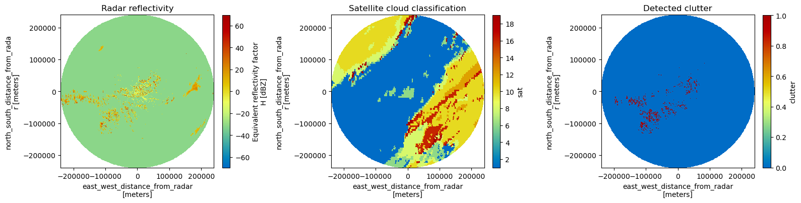
Identify clutter based on collocated cloudtype#
[11]:
rscale = vol.range.diff("range").median().values
clutter = wrl.classify.filter_cloudtype(
    vol.DBZH, val_sat, scale=rscale, smoothing=error
)
Assign to vol#
[12]:
vol = vol.assign(sat=(["tilt", "azimuth", "range"], val_sat))
vol = vol.assign(clutter=(["tilt", "azimuth", "range"], clutter.values))
display(vol)
<xarray.Dataset> Size: 75MB
Dimensions:            (tilt: 5, azimuth: 360, range: 960)
Coordinates: (12/15)
    sweep_mode         (tilt) <U20 400B 'azimuth_surveillance' ... 'azimuth_s...
    elevation          (tilt, azimuth) float64 14kB 0.3 0.3 0.3 ... 6.0 6.0 6.0
    time               (tilt, azimuth) datetime64[ns] 14kB 2013-04-29T04:30:0...
  * range              (range) float32 4kB 125.0 375.0 ... 2.396e+05 2.399e+05
    longitude          float64 8B 5.506
    latitude           float64 8B 49.91
    ...                 ...
    y                  (tilt, azimuth, range) float64 14MB 125.0 ... 2.378e+05
    z                  (tilt, azimuth, range) float64 14MB 592.7 ... 2.901e+04
    gr                 (tilt, azimuth, range) float64 14MB 125.0 ... 2.378e+05
    rays               (azimuth, range) float32 1MB 0.5 0.5 0.5 ... 359.5 359.5
    bins               (azimuth, range) float32 1MB 125.0 375.0 ... 2.399e+05
    crs_wkt            int64 8B 0
Dimensions without coordinates: tilt
Data variables:
    DBZH               (tilt, azimuth, range) float64 14MB -32.0 -32.0 ... -32.0
    sweep_number       (tilt) int64 40B 0 1 2 3 4
    prt_mode           (tilt) <U7 140B 'not_set' 'not_set' ... 'not_set'
    follow_mode        (tilt) <U7 140B 'not_set' 'not_set' ... 'not_set'
    sweep_fixed_angle  (tilt) float64 40B 0.3 0.9 1.8 3.3 6.0
    sat                (tilt, azimuth, range) uint8 2MB 6 6 6 6 ... 10 10 10 10
    clutter            (tilt, azimuth, range) bool 2MB False False ... False
xarray.Dataset
- tilt: 5
- azimuth: 360
- range: 960
- sweep_mode(tilt)<U20'azimuth_surveillance' ... 'azim...
array(['azimuth_surveillance', 'azimuth_surveillance', 'azimuth_surveillance', 'azimuth_surveillance', 'azimuth_surveillance'], dtype='<U20') - elevation(tilt, azimuth)float640.3 0.3 0.3 0.3 ... 6.0 6.0 6.0 6.0
- standard_name :
- ray_elevation_angle
- long_name :
- elevation_angle_from_horizontal_plane
- units :
- degrees
- axis :
- radial_elevation_coordinate
array([[0.3, 0.3, 0.3, ..., 0.3, 0.3, 0.3], [0.9, 0.9, 0.9, ..., 0.9, 0.9, 0.9], [1.8, 1.8, 1.8, ..., 1.8, 1.8, 1.8], [3.3, 3.3, 3.3, ..., 3.3, 3.3, 3.3], [6. , 6. , 6. , ..., 6. , 6. , 6. ]]) - time(tilt, azimuth)datetime64[ns]2013-04-29T04:30:00.027777792 .....
- standard_name :
- time
array([['2013-04-29T04:30:00.027777792', '2013-04-29T04:30:00.083333376', '2013-04-29T04:30:00.138888960', ..., '2013-04-29T04:30:19.861120512', '2013-04-29T04:30:19.916676096', '2013-04-29T04:30:19.972231680'], ['2013-04-29T04:30:20.027777792', '2013-04-29T04:30:20.083333376', '2013-04-29T04:30:20.138888960', ..., '2013-04-29T04:30:39.861120512', '2013-04-29T04:30:39.916676096', '2013-04-29T04:30:39.972231680'], ['2013-04-29T04:30:40.027777792', '2013-04-29T04:30:40.083333376', '2013-04-29T04:30:40.138888960', ..., '2013-04-29T04:30:59.861120512', '2013-04-29T04:30:59.916676096', '2013-04-29T04:30:59.972231680'], ['2013-04-29T04:31:00.027777792', '2013-04-29T04:31:00.083333376', '2013-04-29T04:31:00.138888960', ..., '2013-04-29T04:31:19.861120512', '2013-04-29T04:31:19.916676096', '2013-04-29T04:31:19.972231680'], ['2013-04-29T04:31:20.027777792', '2013-04-29T04:31:20.083333376', '2013-04-29T04:31:20.138888960', ..., '2013-04-29T04:31:39.861120512', '2013-04-29T04:31:39.916676096', '2013-04-29T04:31:39.972231680']], dtype='datetime64[ns]') - range(range)float32125.0 375.0 ... 2.396e+05 2.399e+05
- units :
- meters
- standard_name :
- projection_range_coordinate
- long_name :
- range_to_measurement_volume
- axis :
- radial_range_coordinate
- meters_between_gates :
- 250.0
- spacing_is_constant :
- true
- meters_to_center_of_first_gate :
- 125.0
array([1.25000e+02, 3.75000e+02, 6.25000e+02, ..., 2.39375e+05, 2.39625e+05, 2.39875e+05], dtype=float32) - longitude()float645.506
- long_name :
- longitude
- units :
- degrees_east
- standard_name :
- longitude
array(5.5056)
- latitude()float6449.91
- long_name :
- latitude
- units :
- degrees_north
- positive :
- up
- standard_name :
- latitude
array(49.914299)
- altitude()float64592.0
- long_name :
- altitude
- units :
- meters
- standard_name :
- altitude
array(592.)
- azimuth(azimuth)float320.5 1.5 2.5 ... 357.5 358.5 359.5
- standard_name :
- ray_azimuth_angle
- long_name :
- azimuth_angle_from_true_north
- units :
- degrees
- axis :
- radial_azimuth_coordinate
array([ 0.5, 1.5, 2.5, ..., 357.5, 358.5, 359.5], dtype=float32)
- x(tilt, azimuth, range)float641.091 3.272 ... -2.075e+03
- standard_name :
- east_west_distance_from_radar
- units :
- meters
array([[[ 1.09072907e+00, 3.27218669e+00, 5.45364364e+00, ..., 2.08788474e+03, 2.09006382e+03, 2.09224289e+03], [ 3.27185102e+00, 9.81555154e+00, 1.63592500e+01, ..., 6.26301070e+03, 6.26954727e+03, 6.27608382e+03], [ 5.45197631e+00, 1.63559264e+01, 2.72598731e+01, ..., 1.04362288e+04, 1.04471209e+04, 1.04580129e+04], ..., [-5.45199540e+00, -1.63559837e+01, -2.72599685e+01, ..., -1.04362654e+04, -1.04471575e+04, -1.04580496e+04], [-3.27182541e+00, -9.81547471e+00, -1.63591220e+01, ..., -6.26296168e+03, -6.26949820e+03, -6.27603470e+03], [-1.09071812e+00, -3.27215386e+00, -5.45358893e+00, ..., -2.08786379e+03, -2.09004285e+03, -2.09222191e+03]], [[ 1.09060929e+00, 3.27182635e+00, 5.45304138e+00, ..., 2.08704001e+03, 2.08921756e+03, 2.09139511e+03], [ 3.27149172e+00, 9.81447061e+00, 1.63574434e+01, ..., 6.26047676e+03, 6.26700876e+03, 6.27354074e+03], [ 5.45137759e+00, 1.63541252e+01, 2.72568627e+01, ..., 1.04320065e+04, 1.04428909e+04, 1.04537753e+04], ... [-5.44302541e+00, -1.63290485e+01, -2.72150347e+01, ..., -1.04037695e+04, -1.04146117e+04, -1.04254538e+04], [-3.26644238e+00, -9.79931052e+00, -1.63321565e+01, ..., -6.24346038e+03, -6.24996695e+03, -6.25647350e+03], [-1.08892360e+00, -3.26676526e+00, -5.44459953e+00, ..., -2.08136271e+03, -2.08353178e+03, -2.08570085e+03]], [[ 1.08476722e+00, 3.25429164e+00, 5.42380270e+00, ..., 2.07068718e+03, 2.07284229e+03, 2.07499739e+03], [ 3.25396732e+00, 9.76187191e+00, 1.62697364e+01, ..., 6.21142333e+03, 6.21788800e+03, 6.22435261e+03], [ 5.42217621e+00, 1.62664785e+01, 2.71107141e+01, ..., 1.03502674e+04, 1.03610396e+04, 1.03718118e+04], ..., [-5.42219519e+00, -1.62665355e+01, -2.71108090e+01, ..., -1.03503036e+04, -1.03610759e+04, -1.03718481e+04], [-3.25394185e+00, -9.76179550e+00, -1.62696091e+01, ..., -6.21137472e+03, -6.21783933e+03, -6.22430389e+03], [-1.08475634e+00, -3.25425900e+00, -5.42374829e+00, ..., -2.07066641e+03, -2.07282150e+03, -2.07497657e+03]]]) - y(tilt, azimuth, range)float64125.0 375.0 ... 2.375e+05 2.378e+05
- standard_name :
- north_south_distance_from_radar
- units :
- meters
array([[[1.24984798e+02, 3.74954337e+02, 6.24923798e+02, ..., 2.39247180e+05, 2.39496877e+05, 2.39746574e+05], [1.24946729e+02, 3.74840129e+02, 6.24733452e+02, ..., 2.39174308e+05, 2.39423929e+05, 2.39673549e+05], [1.24870598e+02, 3.74611736e+02, 6.24352796e+02, ..., 2.39028577e+05, 2.39278045e+05, 2.39527514e+05], ..., [1.24870598e+02, 3.74611736e+02, 6.24352796e+02, ..., 2.39028577e+05, 2.39278045e+05, 2.39527514e+05], [1.24946729e+02, 3.74840129e+02, 6.24733452e+02, ..., 2.39174308e+05, 2.39423929e+05, 2.39673549e+05], [1.24984798e+02, 3.74954337e+02, 6.24923798e+02, ..., 2.39247180e+05, 2.39496877e+05, 2.39746574e+05]], [[1.24971073e+02, 3.74913046e+02, 6.24854787e+02, ..., 2.39150384e+05, 2.39399906e+05, 2.39649428e+05], [1.24933008e+02, 3.74798851e+02, 6.24664461e+02, ..., 2.39077541e+05, 2.39326987e+05, 2.39576433e+05], [1.24856885e+02, 3.74570482e+02, 6.24283848e+02, ..., 2.38931869e+05, 2.39181163e+05, 2.39430457e+05], ... [1.24665152e+02, 3.73994823e+02, 6.23323648e+02, ..., 2.38284301e+05, 2.38532627e+05, 2.38780952e+05], [1.24741158e+02, 3.74222840e+02, 6.23703676e+02, ..., 2.38429578e+05, 2.38678056e+05, 2.38926532e+05], [1.24779165e+02, 3.74336860e+02, 6.23893708e+02, ..., 2.38502224e+05, 2.38750777e+05, 2.38999329e+05]], [[1.24301641e+02, 3.72903774e+02, 6.21504376e+02, ..., 2.37276541e+05, 2.37523492e+05, 2.37770440e+05], [1.24263780e+02, 3.72790191e+02, 6.21315071e+02, ..., 2.37204269e+05, 2.37451144e+05, 2.37698017e+05], [1.24188065e+02, 3.72563047e+02, 6.20936499e+02, ..., 2.37059738e+05, 2.37306463e+05, 2.37553186e+05], ..., [1.24188065e+02, 3.72563047e+02, 6.20936499e+02, ..., 2.37059738e+05, 2.37306463e+05, 2.37553186e+05], [1.24263780e+02, 3.72790191e+02, 6.21315071e+02, ..., 2.37204269e+05, 2.37451144e+05, 2.37698017e+05], [1.24301641e+02, 3.72903774e+02, 6.21504376e+02, ..., 2.37276541e+05, 2.37523492e+05, 2.37770440e+05]]]) - z(tilt, azimuth, range)float64592.7 594.0 ... 2.897e+04 2.901e+04
- standard_name :
- height_above_ground
- units :
- meters
array([[[ 592.65541586, 593.97176982, 595.29548679, ..., 5219.41713182, 5227.77555831, 5236.14121094], [ 592.65541586, 593.97176982, 595.29548679, ..., 5219.41713182, 5227.77555831, 5236.14121094], [ 592.65541586, 593.97176982, 595.29548679, ..., 5219.41713182, 5227.77555831, 5236.14121094], ..., [ 592.65541586, 593.97176982, 595.29548679, ..., 5219.41713182, 5227.77555831, 5236.14121094], [ 592.65541586, 593.97176982, 595.29548679, ..., 5219.41713182, 5227.77555831, 5236.14121094], [ 592.65541586, 593.97176982, 595.29548679, ..., 5219.41713182, 5227.77555831, 5236.14121094]], [[ 593.96433484, 597.89852556, 601.84007766, ..., 7724.26223454, 7735.23383411, 7746.21265174], [ 593.96433484, 597.89852556, 601.84007766, ..., 7724.26223454, 7735.23383411, 7746.21265174], [ 593.96433484, 597.89852556, 601.84007766, ..., 7724.26223454, 7735.23383411, 7746.21265174], ... [ 599.19642072, 613.59476625, 628.00045055, ..., 17729.40852951, 17750.81029583, 17772.219232 ], [ 599.19642072, 613.59476625, 628.00045055, ..., 17729.40852951, 17750.81029583, 17772.219232 ], [ 599.19642072, 613.59476625, 628.00045055, ..., 17729.40852951, 17750.81029583, 17772.219232 ]], [[ 605.06696825, 631.20636679, 657.35304799, ..., 28941.47843619, 28974.55401505, 29007.63667964], [ 605.06696825, 631.20636679, 657.35304799, ..., 28941.47843619, 28974.55401505, 29007.63667964], [ 605.06696825, 631.20636679, 657.35304799, ..., 28941.47843619, 28974.55401505, 29007.63667964], ..., [ 605.06696825, 631.20636679, 657.35304799, ..., 28941.47843619, 28974.55401505, 29007.63667964], [ 605.06696825, 631.20636679, 657.35304799, ..., 28941.47843619, 28974.55401505, 29007.63667964], [ 605.06696825, 631.20636679, 657.35304799, ..., 28941.47843619, 28974.55401505, 29007.63667964]]]) - gr(tilt, azimuth, range)float64125.0 375.0 ... 2.375e+05 2.378e+05
- standard_name :
- distance_from_radar
- units :
- meters
array([[[1.24989559e+02, 3.74968616e+02, 6.24947596e+02, ..., 2.39256290e+05, 2.39505997e+05, 2.39755703e+05], [1.24989561e+02, 3.74968623e+02, 6.24947608e+02, ..., 2.39256295e+05, 2.39506002e+05, 2.39755708e+05], [1.24989562e+02, 3.74968625e+02, 6.24947611e+02, ..., 2.39256296e+05, 2.39506003e+05, 2.39755709e+05], ..., [1.24989563e+02, 3.74968628e+02, 6.24947615e+02, ..., 2.39256298e+05, 2.39506004e+05, 2.39755710e+05], [1.24989561e+02, 3.74968621e+02, 6.24947605e+02, ..., 2.39256294e+05, 2.39506000e+05, 2.39755706e+05], [1.24989559e+02, 3.74968616e+02, 6.24947595e+02, ..., 2.39256290e+05, 2.39505997e+05, 2.39755703e+05]], [[1.24975833e+02, 3.74927323e+02, 6.24878581e+02, ..., 2.39159490e+05, 2.39409022e+05, 2.39658553e+05], [1.24975836e+02, 3.74927330e+02, 6.24878594e+02, ..., 2.39159495e+05, 2.39409027e+05, 2.39658558e+05], [1.24975836e+02, 3.74927332e+02, 6.24878597e+02, ..., 2.39159496e+05, 2.39409028e+05, 2.39658559e+05], ... [1.24783922e+02, 3.74351127e+02, 6.23917486e+02, ..., 2.38511313e+05, 2.38759876e+05, 2.39008438e+05], [1.24783919e+02, 3.74351121e+02, 6.23917475e+02, ..., 2.38511309e+05, 2.38759872e+05, 2.39008434e+05], [1.24783918e+02, 3.74351115e+02, 6.23917466e+02, ..., 2.38511306e+05, 2.38759869e+05, 2.39008430e+05]], [[1.24306375e+02, 3.72917975e+02, 6.21528043e+02, ..., 2.37285576e+05, 2.37532536e+05, 2.37779494e+05], [1.24306378e+02, 3.72917982e+02, 6.21528055e+02, ..., 2.37285581e+05, 2.37532541e+05, 2.37779499e+05], [1.24306378e+02, 3.72917984e+02, 6.21528058e+02, ..., 2.37285582e+05, 2.37532542e+05, 2.37779500e+05], ..., [1.24306379e+02, 3.72917987e+02, 6.21528063e+02, ..., 2.37285584e+05, 2.37532544e+05, 2.37779502e+05], [1.24306377e+02, 3.72917980e+02, 6.21528052e+02, ..., 2.37285580e+05, 2.37532540e+05, 2.37779497e+05], [1.24306375e+02, 3.72917975e+02, 6.21528043e+02, ..., 2.37285576e+05, 2.37532536e+05, 2.37779494e+05]]]) - rays(azimuth, range)float320.5 0.5 0.5 ... 359.5 359.5 359.5
- standard_name :
- ray_azimuth_angle
- long_name :
- azimuth_angle_from_true_north
- units :
- degrees
- axis :
- radial_azimuth_coordinate
array([[ 0.5, 0.5, 0.5, ..., 0.5, 0.5, 0.5], [ 1.5, 1.5, 1.5, ..., 1.5, 1.5, 1.5], [ 2.5, 2.5, 2.5, ..., 2.5, 2.5, 2.5], ..., [357.5, 357.5, 357.5, ..., 357.5, 357.5, 357.5], [358.5, 358.5, 358.5, ..., 358.5, 358.5, 358.5], [359.5, 359.5, 359.5, ..., 359.5, 359.5, 359.5]], dtype=float32) - bins(azimuth, range)float32125.0 375.0 ... 2.396e+05 2.399e+05
- units :
- meters
- standard_name :
- projection_range_coordinate
- long_name :
- range_to_measurement_volume
- axis :
- radial_range_coordinate
- meters_between_gates :
- 250.0
- spacing_is_constant :
- true
- meters_to_center_of_first_gate :
- 125.0
array([[1.25000e+02, 3.75000e+02, 6.25000e+02, ..., 2.39375e+05, 2.39625e+05, 2.39875e+05], [1.25000e+02, 3.75000e+02, 6.25000e+02, ..., 2.39375e+05, 2.39625e+05, 2.39875e+05], [1.25000e+02, 3.75000e+02, 6.25000e+02, ..., 2.39375e+05, 2.39625e+05, 2.39875e+05], ..., [1.25000e+02, 3.75000e+02, 6.25000e+02, ..., 2.39375e+05, 2.39625e+05, 2.39875e+05], [1.25000e+02, 3.75000e+02, 6.25000e+02, ..., 2.39375e+05, 2.39625e+05, 2.39875e+05], [1.25000e+02, 3.75000e+02, 6.25000e+02, ..., 2.39375e+05, 2.39625e+05, 2.39875e+05]], dtype=float32) - crs_wkt()int640
- crs_wkt :
- PROJCRS["unknown",BASEGEOGCRS["unknown",DATUM["World Geodetic System 1984",ELLIPSOID["WGS 84",6378137,298.257223563,LENGTHUNIT["metre",1]],ID["EPSG",6326]],PRIMEM["Greenwich",0,ANGLEUNIT["degree",0.0174532925199433],ID["EPSG",8901]]],CONVERSION["unknown",METHOD["Azimuthal Equidistant",ID["EPSG",1125]],PARAMETER["Latitude of natural origin",49.914299,ANGLEUNIT["degree",0.0174532925199433],ID["EPSG",8801]],PARAMETER["Longitude of natural origin",5.5056,ANGLEUNIT["degree",0.0174532925199433],ID["EPSG",8802]],PARAMETER["False easting",0,LENGTHUNIT["metre",1],ID["EPSG",8806]],PARAMETER["False northing",0,LENGTHUNIT["metre",1],ID["EPSG",8807]]],CS[Cartesian,2],AXIS["(E)",east,ORDER[1],LENGTHUNIT["metre",1,ID["EPSG",9001]]],AXIS["(N)",north,ORDER[2],LENGTHUNIT["metre",1,ID["EPSG",9001]]]]
- semi_major_axis :
- 6378137.0
- semi_minor_axis :
- 6356752.314245179
- inverse_flattening :
- 298.257223563
- reference_ellipsoid_name :
- WGS 84
- longitude_of_prime_meridian :
- 0.0
- prime_meridian_name :
- Greenwich
- geographic_crs_name :
- unknown
- horizontal_datum_name :
- World Geodetic System 1984
- projected_crs_name :
- unknown
- grid_mapping_name :
- azimuthal_equidistant
- latitude_of_projection_origin :
- 49.914299
- longitude_of_projection_origin :
- 5.5056
- false_easting :
- 0.0
- false_northing :
- 0.0
array(0)
- DBZH(tilt, azimuth, range)float64-32.0 -32.0 -32.0 ... -32.0 -32.0
- _Undetect :
- 0.0
- units :
- dBZ
- standard_name :
- radar_equivalent_reflectivity_factor_h
- long_name :
- Equivalent reflectivity factor H
array([[[-32. , -32. , -32. , ..., -32. , -32. , -32. ], [-32. , -32. , -32. , ..., -32. , -32. , -32. ], [-32. , -7.5, 4. , ..., -32. , -32. , -32. ], ..., [-32. , -3.5, -2. , ..., -32. , -32. , -32. ], [-32. , -32. , -32. , ..., -32. , -32. , -32. ], [-32. , -32. , -32. , ..., -32. , -32. , -32. ]], [[-32. , -32. , -32. , ..., -32. , -32. , -32. ], [-32. , -32. , -32. , ..., -32. , -32. , -32. ], [-32. , -32. , -32. , ..., -32. , -32. , -32. ], ..., [-32. , -6. , 2.5, ..., -32. , -32. , -32. ], [-32. , -32. , 0. , ..., -32. , -32. , -32. ], [-32. , -32. , -32. , ..., -32. , -32. , -32. ]], [[-32. , -32. , -32. , ..., -32. , -32. , -32. ], [-32. , -32. , -32. , ..., -32. , -32. , -32. ], [-32. , -32. , -32. , ..., -32. , -32. , -32. ], ..., [-32. , -32. , 2. , ..., -32. , -32. , -32. ], [-32. , -32. , -32. , ..., -32. , -32. , -32. ], [-32. , -32. , -32. , ..., -32. , -32. , -32. ]], [[-32. , -32. , 15.5, ..., -32. , -32. , -32. ], [-32. , -32. , -32. , ..., -32. , -32. , -32. ], [-32. , -32. , 5. , ..., -32. , -32. , -32. ], ..., [-32. , -6. , 1.5, ..., -32. , -32. , -32. ], [-32. , -8.5, 4. , ..., -32. , -32. , -32. ], [-32. , -32. , 12. , ..., -32. , -32. , -32. ]], [[-32. , -5. , 5.5, ..., -32. , -32. , -32. ], [-32. , -32. , -32. , ..., -32. , -32. , -32. ], [-32. , -4. , 2. , ..., -32. , -32. , -32. ], ..., [-32. , -32. , -32. , ..., -32. , -32. , -32. ], [-32. , -32. , -32. , ..., -32. , -32. , -32. ], [-32. , -32. , -32. , ..., -32. , -32. , -32. ]]]) - sweep_number(tilt)int640 1 2 3 4
array([0, 1, 2, 3, 4])
- prt_mode(tilt)<U7'not_set' 'not_set' ... 'not_set'
array(['not_set', 'not_set', 'not_set', 'not_set', 'not_set'], dtype='<U7')
- follow_mode(tilt)<U7'not_set' 'not_set' ... 'not_set'
array(['not_set', 'not_set', 'not_set', 'not_set', 'not_set'], dtype='<U7')
- sweep_fixed_angle(tilt)float640.3 0.9 1.8 3.3 6.0
array([0.3, 0.9, 1.8, 3.3, 6. ])
- sat(tilt, azimuth, range)uint86 6 6 6 6 6 6 ... 10 10 10 10 10 10
array([[[ 6, 6, 6, ..., 10, 10, 10], [ 6, 6, 6, ..., 10, 10, 10], [ 6, 6, 6, ..., 10, 10, 10], ..., [ 6, 6, 6, ..., 10, 10, 10], [ 6, 6, 6, ..., 10, 10, 10], [ 6, 6, 6, ..., 10, 10, 10]], [[ 6, 6, 6, ..., 10, 10, 10], [ 6, 6, 6, ..., 10, 10, 10], [ 6, 6, 6, ..., 10, 10, 10], ..., [ 6, 6, 6, ..., 10, 10, 10], [ 6, 6, 6, ..., 10, 10, 10], [ 6, 6, 6, ..., 10, 10, 10]], [[ 6, 6, 6, ..., 10, 10, 10], [ 6, 6, 6, ..., 10, 10, 10], [ 6, 6, 6, ..., 10, 10, 10], ..., [ 6, 6, 6, ..., 10, 10, 10], [ 6, 6, 6, ..., 10, 10, 10], [ 6, 6, 6, ..., 10, 10, 10]], [[ 6, 6, 6, ..., 10, 10, 10], [ 6, 6, 6, ..., 10, 10, 10], [ 6, 6, 6, ..., 10, 10, 10], ..., [ 6, 6, 6, ..., 10, 10, 10], [ 6, 6, 6, ..., 10, 10, 10], [ 6, 6, 6, ..., 10, 10, 10]], [[ 6, 6, 6, ..., 10, 10, 10], [ 6, 6, 6, ..., 16, 16, 10], [ 6, 6, 6, ..., 16, 16, 16], ..., [ 6, 6, 6, ..., 10, 10, 10], [ 6, 6, 6, ..., 10, 10, 10], [ 6, 6, 6, ..., 10, 10, 10]]], dtype=uint8) - clutter(tilt, azimuth, range)boolFalse False False ... False False
array([[[False, False, False, ..., False, False, False],
        [False, False, False, ..., False, False, False],
        [False, False, False, ..., False, False, False],
        ...,
        [False, False, False, ..., False, False, False],
        [False, False, False, ..., False, False, False],
        [False, False, False, ..., False, False, False]],

       [[False, False, False, ..., False, False, False],
        [False, False, False, ..., False, False, False],
        [False, False, False, ..., False, False, False],
        ...,
        [False, False, False, ..., False, False, False],
        [False, False, False, ..., False, False, False],
        [False, False, False, ..., False, False, False]]])
- rangePandasIndex
PandasIndex(Index([ 125.0, 375.0, 625.0, 875.0, 1125.0, 1375.0, 1625.0, 1875.0, 2125.0, 2375.0, ... 237625.0, 237875.0, 238125.0, 238375.0, 238625.0, 238875.0, 239125.0, 239375.0, 239625.0, 239875.0], dtype='float32', name='range', length=960)) - azimuthPandasIndex
PandasIndex(Index([  0.5,   1.5,   2.5,   3.5,   4.5,   5.5,   6.5,   7.5,   8.5,   9.5,
       ...
       350.5, 351.5, 352.5, 353.5, 354.5, 355.5, 356.5, 357.5, 358.5, 359.5],
      dtype='float32', name='azimuth', length=360))
Plot the results#
[13]:
fig = plt.figure(figsize=(16, 8))

tilt = 0

ax = fig.add_subplot(131)
pm = vol.DBZH[tilt].wrl.vis.plot(ax=ax)
# plt.colorbar(pm, shrink=0.5)
plt.title("Radar reflectivity")

ax = fig.add_subplot(132)
pm = vol.sat[tilt].wrl.vis.plot(ax=ax)
# plt.colorbar(pm, shrink=0.5)
plt.title("Satellite cloud classification")

ax = fig.add_subplot(133)
pm = vol.clutter[tilt].wrl.vis.plot(ax=ax)
# plt.colorbar(pm, shrink=0.5)
plt.title("Detected clutter")

fig.tight_layout()